

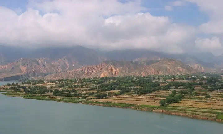
Photo adjustments
Full frame retained; resized proportionally to a maximum dimension of 960 pixels and converted to WebP quality 88. No crop, retouch, generated elements, or subject alteration. Final website rendition: full frame retained, proportionally resized to at most 720 pixels and converted to WebP. No additional retouching or subject alteration. Card displays may crop the view.
Explore the region
About Xunhua
Jiezi is particularly associated with stories of migration from Central Asia: Camel Spring commemorates the legendary white camel, while Jiezi Mosque is connected with a treasured handwritten Quran. These traditions add meaning to the architecture and landscape, but access to a religious manuscript should never be assumed. Separate a visit to the county town from an arranged cultural visit in Jiezi.
Ethnic Salars first arrived in the area during the thirteenth or fourteenth century as part of the Mongol army, settling along the Yellow River. The Ming dynasty established control by 1370, placing the area under the jurisdiction of Hezhou in Gansu; Hui settlers from Hezhou then moved into the region, trading with and marrying local Salars. Many Salars originally carried the surname Han, derived from 'khan,' and adopted the surname Ma, derived from 'Muhammad'; intermarriage between Salars and Hui became more common than marriages between Salars and Tibetans, Mongols or Han Chinese.
The county is the site of the Suzhi necropolis (苏志墓地), a Bronze Age burial ground of the Kayue culture. Xunhua is also home to a mosque holding the oldest hand-written copy of the Quran in China, believed to date from between the eighth and thirteenth centuries. Xunhua is the only autonomous county where the Salar form the sole titular minority, and the Salar language holds official status there, as well as in Jishishan Bonan, Dongxiang and Salar Autonomous County.
Xunhua lies at the edge of the Tibetan Plateau, higher in the south and lower in the north, with mountains on every side; the Yellow River runs through the county for 79 kilometres. The county averages about 2,200 metres in elevation, while its river-valley areas average about 1,850 metres.
What to look for
- Camel Spring gives physical form to a Salar migration legend.
- Jiezi Mosque connects the settlement with a continuing religious tradition.
- The Yellow River valley explains the area’s historical movement and settlement.
Location & getting there
Getting to Xunhua
Begin in Xunhua’s Jishi town, then arrange the onward road connection to Jiezi village and the specific visitor site. Ask locally about mosque access and any guided cultural programme.
Combine your visit
Choose from these complementary stops when planning your visit.
-
Jishi town积石镇
Orient yourself in the county town.
-
Camel Spring骆驼泉
Read the migration story as a local tradition.
-
Jiezi Mosque街子清真大寺
Visit the permitted areas respectfully.
This is a suggested combination, not a timed route; confirm the opening and transport arrangements for your date.
Find Xunhua
循化 · 海东
The pin marks the area, not the entrance.
More places nearby
Approximate straight-line distances between map pins, not travel distances.
Regong Art Museum 热贡艺术博物馆
56 km awayRegong Art Museum introduces the painting, sculpture and appliqué traditions associated with Tongren. Thangka paintings reward close attention to composition and detail, while carved and textile works show how related subjects…
View guide →Tongren, Qinghai 同仁
57 km awayTongren, known locally as Rebgong, is associated with the painting, applique and sculpture collectively recognised as Regong arts. Monks and village artists continue these traditions through apprenticeship. Rongwo Monastery…
View guide →Rongwo Monastery 隆务寺
58 km awayRongwo Monastery is a major Tibetan Buddhist institution in Tongren, also known as Rebgong. Its temples and monastic colleges connect worship with the study of philosophy, ritual and the Kalachakra tradition. The prayer hall and…
View guide →Sources & visit information
The sources below support the place-specific description and arrival information. Suggested combinations are editorial planning ideas; confirm current opening, entry arrangements and transport services for your date.
- China Intangible Cultural Heritage: Salar communities, Camel Spring and Jiezi Mosque ↗
- Xunhua Salar Autonomous County — Wikipedia geographic and historical reference ↗
- Chinese Wikipedia: 循化撒拉族自治县 (revision 84055164, 2024-09-02) ↗
- English Wikipedia: Xunhua Salar Autonomous County (revision 1351747619, 2026-04-29) ↗
Geographic and historical facts selectively adapted from Wikipedia contributors, Xunhua Salar Autonomous County · CC BY-SA 4.0. Source revision 1351747619.
Background paragraphs translated and condensed from Wikipedia contributors, "循化撒拉族自治县", Chinese Wikipedia · CC BY-SA 4.0. Source revision 84055164.
Background paragraphs condensed from Wikipedia contributors, "Xunhua Salar Autonomous County", English Wikipedia · CC BY-SA 4.0. Source revision 1351747619.