

Entry & permits for Tibet (Xizang)
Foreign tourists need Tibet entry approval, commonly called a Tibet Travel Permit, and an organised visit arranged through a specialist travel agency in China. Confirm your approved route before booking transport. Requirements differ for Taiwan residents and for travellers using mainland or Hong Kong/Macao Chinese resident documents; check the document guide before you book.
Check the travel-document requirements →Policy scope verified: 2026-09-06. UK FCDO: China regional travel advice ↗ State Council Taiwan Affairs Office: Tibet entry approval ↗ Xizang Department of Culture and Tourism: Medog border permit notice ↗
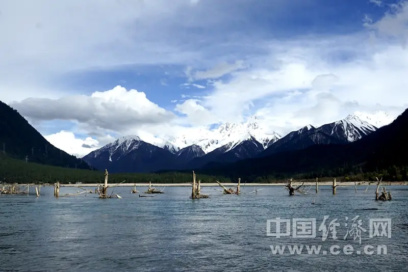
Photo adjustments
EXIF orientation normalized; resized without changing aspect ratio; converted to WebP. No subject edits.
Explore the region
About Guxiang Lake
The Economic Daily account gives the lake a surface elevation of 2,600 metres, a length of about five kilometres, a greatest width of two kilometres and a greatest depth of 20 metres, and says the water is fresh. It dates the lake's formation to 1953, when, on its account, glacial activity at 雄陆给尼 behind Guxiang set off a huge debris flow at 卡贡弄巴 that blocked the Parlung Tsangpo. It places the lake more than 30 kilometres west of the Bomê county seat, a short way up the Parlung Tsangpo from Tongmai along National Highway 318.
The county's own township directory lists 古乡湖景区, the Guxiang Lake scenic area, among the remarkable natural landscapes of 古乡, which it puts along National Highway 318 as the county's western gate, 32 kilometres from the county seat, with the township government seat at 2,516 metres. A 2022 county route description puts the lake about 33 kilometres from the county seat and describes water running below snow mountains with mist lifting off the surface; it places the lake on a spring route between the Bomi peach blossom gully and Zhaxigang village.
The Economic Daily account also prints an area for the lake, but the figure does not agree with its own dimensions and no area is carried here. No cited source gives the lake's catchment, its water temperature, or any depth other than the single greatest figure, and the elevation of 2,516 metres in this record is the 古乡 township government seat, not the lake, whose own surface elevation the same account puts at 2,600 metres.
What to look for
- The dead tree roots, which the Economic Daily account describes as standing askew here and there in the water
- The soft fine sand along the lake shore, which the same account names
- The water itself, which the account describes as blue and clear to the bottom, set against forest and distant snow mountains
- The 古乡湖景区, which the county's township directory lists among the remarkable natural landscapes of 古乡
Location & getting there
Getting to Guxiang Lake
Confirm the visitor entrance and which boat or walking routes operate on your date. Rainfall, water levels and weather can change access.
- Search for 古乡湖 with 林芝市 and 波密县.
Find Guxiang Lake
古乡湖 · 波密县
No reliable map pin yet: search by the Chinese name.
Sources & visit information
The linked sources support the identity and background described in this introduction. Opening hours, admission, activity availability and exact arrival arrangements have not been comprehensively checked. Confirm current visitor information with the venue; the original catalogue locality and editorial review flag are retained.