

Photo adjustments
EXIF orientation normalized; resized without changing aspect ratio; converted to WebP. No subject edits.
Explore the region
About Dabanshi Rock
Fengkai National Geopark covers 1,360 square kilometres over most of the area east of the Hejiang river; the county government describes it as the only county-named geopark in the Xijiang river basin. Besides the Dabanshi zone, the park is made up of Qiceng Fenglin, a stacked-peak forest; Longshan Rongyan, Longshan's karst caves; Liandu Hualang, the Liandu Gallery; and Hejiang Quliu, the Hejiang's meanders. The park's landforms are built from three different rock types, granite, limestone and sandstone or shale, producing boulders, unusual peaks, caves, forest and watercourses, and it also holds fossil sites of ancient humans and animals and old gold-mining sites; the county government records that its geology spans 500 million years of formation and its human-settlement record spans 150,000 years of Lingnan habitation.
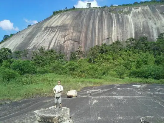
Dabanshi itself is a single mass of rock that forms a hill by itself. Folk tradition gives it two origins: one holds that it is an egg laid by a heavenly dragon, guarded on either side by Baima Shan (White Horse Hill) and Qilin Shan (Qilin Hill); the other holds that it is one of the five-coloured stones left over when the goddess Nüwa smelted stone to mend the sky. The county government records the summer and autumn rice harvest as the season when the scenery is at its finest, with blue sky and golden paddy fields, and records a red pear orchard in winter.
What to look for
- Dabanshi itself, a single rock mass forming its own hill within the geopark's Tianxia Diyi Shi zone.
- Baima Shan and Qilin Shan, the two hills flanking Dabanshi that folk tradition casts as its guardian spirits.
- The golden paddy fields at the summer and autumn rice harvest, which the county government records as the finest season.
- The red pear orchard the county government records for winter.
- The geopark's other four component zones: the stacked-peak forest of Qiceng Fenglin, the karst caves of Longshan Rongyan, the Liandu Gallery and the Hejiang's meanders.
Location & getting there
Getting to Dabanshi Rock
Use an authorised visitor route. Cave sections, geological sites and access roads can close independently, so confirm the area that your ticket covers.
- Search for 大斑石 with 肇庆市 and 封开县.
Find Dabanshi Rock
大斑石 · 封开县
No reliable map pin yet: search by the Chinese name.
Sources & visit information
The linked sources support the identity and background described in this introduction. Opening hours, admission, activity availability and exact arrival arrangements have not been comprehensively checked. Confirm current visitor information with the venue; the original catalogue locality and editorial review flag are retained.