

Photo adjustments
EXIF orientation normalized; resized without changing aspect ratio; converted to WebP. No subject edits.
Explore the region
About Gupo Mountain
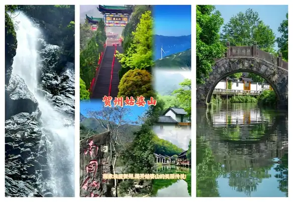
Xiangu Waterfall is a clear focal point, dropping down a rock face beside the wooded route, while the more open Xiangu lawn provides a change of scale. Fangjia Tea Garden adds a cultivated landscape associated with television filming. A lower-park circuit can therefore combine forest, water and a tea garden without assuming that the high summit is part of the same easy outing.
Gupo Mountain (姑婆山), also known as Dongshan, Linheling, Gupoling or Guiling, is part of the Mengzhu Ling (萌渚岭) range, extending from Jianghua Yao Autonomous County in Hunan into Fuchuan Yao Autonomous County (富川瑶族自治县), in Hezhou, where it dominates the county's southeast. It is formed of peaks including Wuyang Shan (乌羊山), Dagui Shan (大桂山) and Chachong (茶冲); the main peak within Fuchuan, Dagui Shan, reaches 830.3 meters, while the range's peak in Jianghua reaches 1415 meters. The terrain slopes from east to northwest, forming the watershed between the Xiang and Xi river systems. It is a granite fault-block formation rich in tin ore; from the Ming dynasty through the Republican era, annual extraction reached more than 100,000 catties (斤).
What to look for
- Xiangu Waterfall drops from a rock face beside the forest route.
- Fangjia Tea Garden contrasts cultivated rows and a filming location with the surrounding woods.
Location & getting there
Getting to Gupo Mountain
From Hezhou, the operator’s road approach follows Guposhan Avenue and Hegu Road to the forest-park entrance. Hezhou railway station is also a documented arrival hub for onward local transport; confirm the current park connection rather than relying on an old bus timetable.
Combine your visit
Suggested order for the visit:
-
Xiangu Waterfall
Begin with the forest and falling water.
-
Xiangu lawn
Pause in a more open part of the park.
-
Fangjia Tea Garden
Continue with the cultivated landscape where the visitor route operates.
This is an editorial sequence of named spaces or places. It does not imply a verified walking connection or promise opening, ticket availability or a journey time.

Find Gupo Mountain
姑婆山 · 贺州
The pin marks the area, not the entrance.
More places nearby
Approximate straight-line distances between map pins, not travel distances.
Huangyao 黄姚古镇
55 km awayHuangyao’s older streets follow streams and stone bridges through a compact settlement beneath limestone hills. Blue-brick walls, dark tiled roofs and worked timber give the lanes a consistent material character, while the worn…
View guide →Gongcheng Confucian Temple 恭城文庙
78 km awayGongcheng’s Confucian Temple is laid out on rising ground, so its sequence of gates and halls becomes more elevated as you move inward. The Lingxing Gate, pool and bridge establish the ceremonial approach before the main Dacheng…
View guide →Li River 漓江
93 km awayThe Li River is the setting for the limestone landscape between Guilin and Yangshuo. Some hills form connected clusters, while others rise as steep individual towers above relatively flat ground. Seeing these forms from the…
View guide →Sources & visit information
The sources below support the place-specific description and arrival information. Suggested combinations are editorial planning ideas; confirm current opening, entry arrangements and transport services for your date.
- Gupo Mountain official portal: park features ↗
- Gupo Mountain official portal: transport ↗
- Chinese Wikipedia: 姑婆山系 (revision 92403097, 2026-04-24) ↗
Background paragraphs translated and condensed from Wikipedia contributors, "姑婆山系", Chinese Wikipedia · CC BY-SA 4.0. Source revision 92403097.