

Photo adjustments
EXIF orientation normalized; resized without changing aspect ratio; converted to WebP. No subject edits.
Explore the region
About Wumeng Grassland
The broad skyline is the main attraction outside the flowering season; when the shrubs bloom, colour follows the contours of the uplands. Conditions can change quickly on exposed ground. Choose the maintained scenic paths and designated viewing or camping areas, keeping the visit within the managed landscape rather than driving or pitching tents on open vegetation.
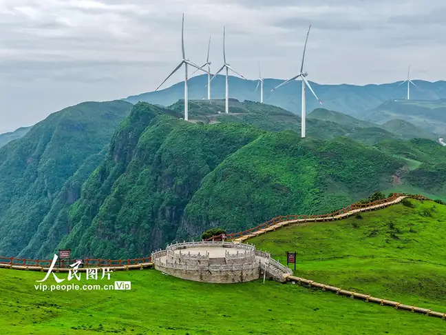
Wumeng Grassland lies in Wumeng town and Pingdi Yi ethnic township, in the northern part of Panzhou, at an elevation of between 2000 m and 2857 m. It forms part of the Wumeng Mountain National Geopark (乌蒙山国家地质公园) and is designated a provincial-level scenic area (省级风景名胜区) of Guizhou.
The grassland is underlain by basalt and karst terrain. Alongside its rhododendron forest, the area includes the alpine lake Changhaizi (长海子), settlements of the Yi ethnic group, the peaks of Niupengliangzi (牛棚梁子) and Badanzi (八担子山), and an unusual natural phenomenon known as 'Buddha's light' (佛光).
What to look for
- Rolling upland grassland creates long, open views across the hills.
- Dwarf rhododendron communities add a different texture and seasonal flowers.
Location & getting there
Getting to Wumeng Grassland
Use the Wumeng Grassland scenic entrance in the Pingdi Yi Township area of Panzhou. The wider protected landscape also reaches Wumeng town, so confirm the named visitor entrance with your driver rather than selecting a general grassland location.
Combine your visit
Suggested order for the visit:
-
Grassland viewing area
Begin with the open upland panorama.
-
Rhododendron area
Look at the low-growing shrubs along the permitted route.
-
Designated rest area
Finish within the managed visitor facilities.
This is an editorial sequence of named spaces or places. It does not imply a verified walking connection or promise opening, ticket availability or a journey time.

Find Wumeng Grassland
乌蒙大草原 · 六盘水
The pin marks the area, not the entrance.
More places nearby
Approximate straight-line distances between map pins, not travel distances.
Yushe National Forest Park 玉舍国家森林公园
38 km awayYushe National Forest Park offers a wooded mountain landscape where streams and small waterfalls interrupt the forest paths. Its character changes with the season: rhododendrons provide spring colour, leaves change in autumn…
View guide →Shuicheng Old Town 水城古镇
53 km awayShuicheng Old Town, also called Hecheng, follows the river through the older part of Liupanshui. Today it is a developed cultural and food district, with waterside streets, historic-house stops and the Guizhou Third Front…
View guide →Weining Caohai 威宁草海
85 km awayCaohai is a shallow highland wetland beside Weining, with open water, reed beds and a wintering population of black-necked cranes and other waterbirds. The public landscape around the reserve provides the appropriate way to…
View guide →Sources & visit information
The sources below support the place-specific description and arrival information. Suggested combinations are editorial planning ideas; confirm current opening, entry arrangements and transport services for your date.
- Liupanshui People’s Congress: Wumeng Grassland ↗
- Guizhou scenic-area directory ↗
- Chinese Wikipedia: 乌蒙大草原 (revision 92541262, 2026-05-05) ↗
Background paragraphs translated and condensed from Wikipedia contributors, "乌蒙大草原", Chinese Wikipedia · CC BY-SA 4.0. Source revision 92541262.