

Photo adjustments
Full source framing retained; proportionally resized and converted to WebP. No retouching or subject alteration. Card displays may crop the view.
Explore the region
About Xiaoqikong Scenic Area
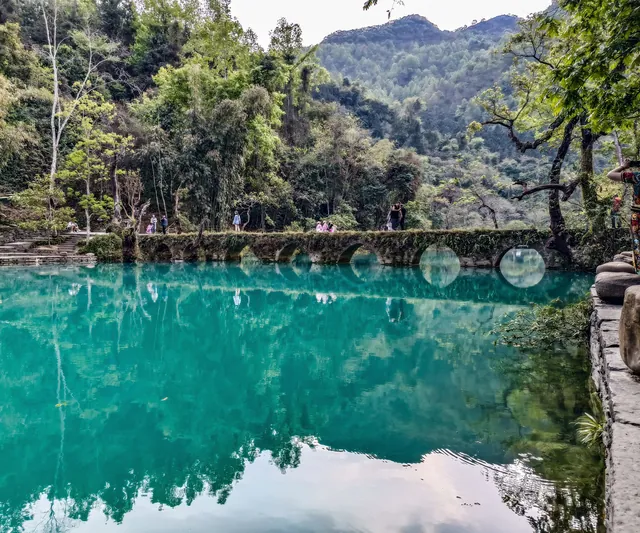
The district takes its name from the old Xiaoqikong bridge, an arched crossing of the Xiangshui river built in 1835, the fifteenth year of the Daoguang reign, on what was then the trade road from southern Guizhou into Guangxi; it is 40 metres long, 2.2 metres wide and 5.5 metres high. The Xiangshui river itself is the surface reach of the lower Huanghou underground river, emerging at the foot of Guibei Mountain and running 1.6 kilometres with a fall of 314 metres and an average flow of 8.03 cubic metres a second; its name comes from the noise of its many falls. Along that reach the 68-step cascade drops about 110 metres over some 1.6 kilometres at a width of about 40 metres, packing sixty-eight falls and cascades of different shapes into less than two kilometres of winding channel. The county's account attributes the cascade to strong late-stage uplift of the plateau, which let the river cut down by 350 to 500 metres.
Zhangjiang, of which this is one district, takes in the Daqikong and Xiaoqikong districts, the Shuichunhe district and the Zhangjiang riverside belt, 118.8 square kilometres in all, with 48 recorded scenic resources. The State Council listed it in the third batch of national scenic areas in 1994, and in 2007 UNESCO inscribed it on the World Heritage List as part of the South China Karst. The prefecture rates the Zhangjiang tourist area AAAAA.
What to look for
- The old Xiaoqikong bridge of 1835, an arched crossing of the Xiangshui river 40 metres long and 2.2 metres wide.
- The 68-step cascade in the Xiangshui valley, about 110 metres of total drop in some 1.6 kilometres of channel.
- The Laya waterfall, which issues from a cave spring in the hillside and falls 30 metres clear of the cliff over a width of more than 20 metres; the name means 'beautiful goddess' in Bouyei.
- Yuanyang Lake, a karst blind-valley lake of about 20 hectares and some 40 metres deep, made up of an upper and a lower lake on the surface reach of the Huanghou underground river.
- The Nuneijihai wetland, 50 hectares of plateau karst retention wetland about six kilometres from Yuanyang Lake, whose name means 'beautiful place' in Yao.
Location & getting there
Getting to Xiaoqikong Scenic Area
Confirm the visitor entrance and which boat or walking routes operate on your date. Rainfall, water levels and weather can change access.
- Search for 小七孔 with 黔南布依族苗族自治州 and 荔波县.

Find Xiaoqikong Scenic Area
小七孔 · 荔波县
No reliable map pin yet: search by the Chinese name.
Sources & visit information
The linked sources support the identity and background described in this introduction. Opening hours, admission, activity availability and exact arrival arrangements have not been comprehensively checked. Confirm current visitor information with the venue; the original catalogue locality and editorial review flag are retained.