

Photo adjustments
Proportionally resized and converted to WebP without cropping, retouching or changing the photographed subject.
About Menyuan
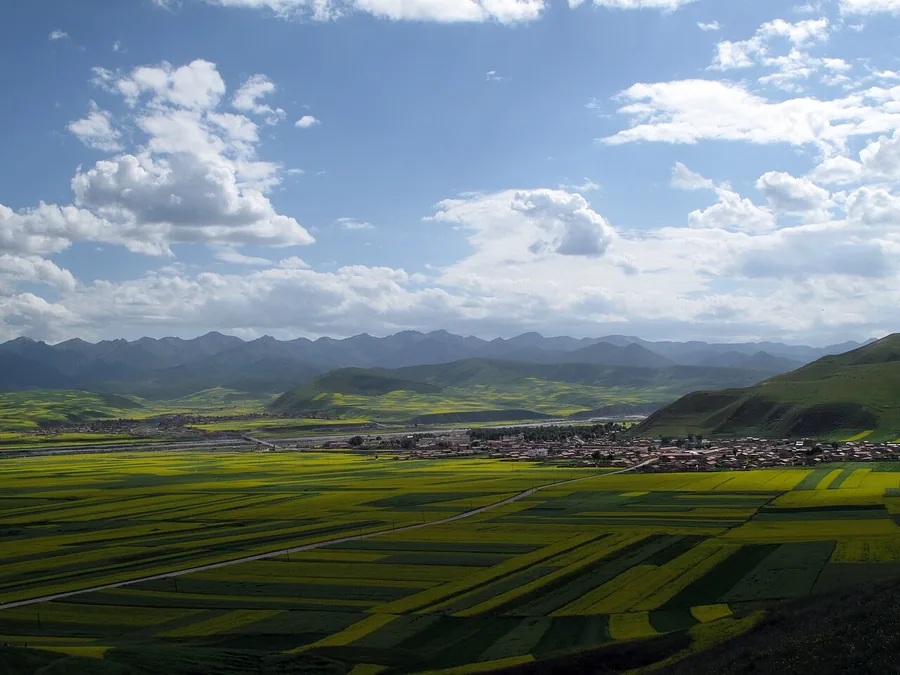
In the flowering season, the fields form a patchwork against the mountain skyline rather than a single enclosed garden. Yuanshan Viewing Platform provides an elevated way to understand their scale. Outside the flowering period, the same area is a working agricultural landscape; photographs of yellow summer fields should not be read as a year-round promise.
What to look for
- The broad farming valley contrasts with the surrounding mountains.
- Yuanshan Viewing Platform looks across the field pattern.
- Seasonal rapeseed flowers transform the landscape when the crop is in bloom.
Background & history
Menyuan Hui Autonomous County (simplified Chinese: 门源回族自治县; traditional Chinese: 門源回族自治縣; pinyin: Ményuán Huízú Zìzhìxiàn, Xiao'erjing: مٍیُوًا خُوِذُو ذِجِشِیًا; Tibetan: སེམས་ཉིད་ཧུའེ་རིགས་རང་སྐྱོང་ཞན།) is a county in the northeast of Qinghai Province, China, bordering Gansu Province to the north. It is under the administration of Haibei Tibetan Autonomous Prefecture. Menyuan is situated on the Datong River between the Qilian Mountains and Daban Mountains. Gangshiqia Peak rises dramatically in the north of the county. It used to be called Menyuan (亹源) in Chinese, with a different first character from the current name.
Excerpt from Wikipedia: Menyuan Hui Autonomous County · Wikipedia contributors · CC BY-SA 4.0. Selected introductory sentences; formatting simplified. Background information, not current visitor-service advice.
Location & getting there
Getting to Menyuan
Menyuan railway station provides a rail arrival point for the county. Arrange the onward connection to Haomen town or the named flower-viewing area; the fields and viewing platforms are not inside the station.
Combine your visit
Choose from these complementary stops when planning your visit.
-
Haomen visitor base浩门镇
Check current flowering conditions and local transport.
-
Yuanshan Viewing Platform圆山观花台
See the scale of the agricultural valley.
-
Designated field-viewing paths油菜花海观赏步道
Use established visitor routes without entering working crops.
Flowering varies with the season and weather. Check current local reports before travelling specifically for yellow fields, and remain on designated viewing paths.

Find Menyuan
门源 · 海北州
The pin marks the area, not the entrance.
More places nearby
Approximate straight-line distances between map pins, not travel distances.
Huzhu Tu Homeland互助土族故土园
74 km awayHuzhu Tu Homeland brings together several visitor areas around Weiyuan, with Tu dress, embroidery, courtyard architecture and performance traditions as its focus. Xiaozhuang village adds a community setting, while other…
View guide →Qinghai Tibetan Culture Museum青海藏文化博物院
83 km awayQinghai Tibetan Culture Museum covers both Tibetan medicine and a wider artistic and cultural tradition. The northern and southern buildings have different emphases, so choose your galleries before buying a ticket. The large…
View guide →Atomic City Memorial Museum原子城纪念馆
88 km awayAtomic City Memorial explains the history of the former nuclear-research base on the Jinyintan grassland. Its exhibition follows the base from planning and construction through research and retirement. Photographs and objects…
View guide →Sources & visit information
The sources below support the place-specific description and arrival information. Suggested combinations are editorial planning ideas; confirm current opening, entry arrangements and transport services for your date.
- Xinhua on-site report: Menyuan valley and Yuanshan viewing platform ↗
- Hainan Prefecture Government: Menyuan seasonal flower landscape ↗
- Menyuan Hui Autonomous County — Wikipedia geographic and historical reference ↗
Geographic and historical facts selectively adapted from Wikipedia contributors, Menyuan Hui Autonomous County · CC BY-SA 4.0. Source revision 1336938315.