

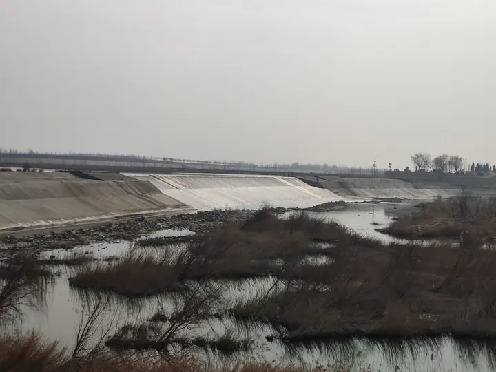
Photo adjustments
Full frame retained; proportionally resized and converted to WebP. No retouching or changes to the photographed subject. Card displays may crop the view.
About Daicun Dam
Daicun Dam (戴村坝) is a Ming-dynasty weir across the Dawen River (大汶河) near Nanchengzi village (南城子村) in Dongping County (东平县), Tai'an (泰安), Shandong. It diverted the river to feed the highest stretch of the Beijing–Hangzhou Grand Canal and is known as the "heart of the canal" (运河之心).
The dam stands where the Dawen River becomes the Daqing River (大清河), which flows on west to Dongping Lake (东平湖). In 1391 the Yellow River breached its banks at Yuanwu in Henan and silted up the canal, so boats could no longer pass between Jining (济宁) and Linqing (临清). In 1411 the Yongle Emperor sent the Minister of Works Song Li (宋礼) to reopen the Huitong Canal (会通河), but its summit at Nanwang (南旺) in Wenshang County lay more than 3 m above Jining and ran short of water. Song Li took the advice of Bai Ying (白英), an old man of Wenshang, to draw on the Wen River. A dam site 13 m above Nanwang was chosen, and in the second month of 1411 work began on an earth dam set on timber piles. It turned the river into the newly dug Xiaowen River (小汶河) and on to Nanwang, where the water was split, by the old saying, "seven parts north to the emperor, three parts south to Jiangnan". The Tai'an Water Resources Bureau credits the dam with keeping grain barges moving for some 500 years.
Today's dam, 1,599.5 m in all, is the product of repeated rebuilding. Stone facing was added to the southern part of the earth dam in 1573; the Linglong (玲珑坝) section was built in 1589 and the Luanshi (乱石坝) and Gunshui (滚水坝) sections in 1593. These three form the 437.5 m main stone dam, set at slightly different heights so that rising water spills over in stages. The Dougong Embankment (窦公堤) slows the current coming from the east, and a lime-and-earth dam added in 1822 takes overflow in big floods. The stones were locked together with iron clamps. A flood broke the Luanshi section in 2001, and it was repaired between 2002 and 2005.
The dam is a major national protected site and part of the Grand Canal World Heritage listing of 2014. People's Daily Online describes water pouring over the crest in three falls, as seen from Tiger Roar Pavilion (虎啸亭), with carp leaping in the white water below. Dongping County built the Daicun Dam Museum in 2011.
What to look for
- The 437.5 m main stone dam with its three stepped sections: Linglong, Luanshi and Gunshui
- The Dougong Embankment (窦公堤) and the 1822 lime-and-earth dam (三合土坝)
- Tiger Roar Pavilion (虎啸亭), facing the falls over the dam crest
- The Daicun Dam Museum (戴村坝博物馆), built in 2011, on the dam's history, design and structure
- The Xiaowen River (小汶河) on the dam's south side, the Ming channel that carried the water to Nanwang
Location & getting there
Getting to Daicun Dam
- Search for 戴村坝 with 泰安市 and 东平县.
Find Daicun Dam
戴村坝 · 东平县
No reliable map pin yet: search by the Chinese name.
Sources & visit information
Written from the linked sources and checked sentence by sentence against quoted extracts by a separate reviewer on 2026-09-23. Opening hours, admission and access arrangements are not covered; confirm current visitor information with the site.
Some facts checked against Wikipedia contributors, "戴村坝" · CC BY-SA 4.0.