

Photo adjustments
Full-frame source proportionally resized and converted to WebP for display. No subject alteration. Source-supplied marks and edits remain; cards may crop the view.
Explore the region
About Kinmen National Park
Zhongshanlin Visitor Center introduces these themes together, helping explain why a village, a tunnel and a wetland belong to the same park. This is a network of places rather than one enclosed scenic area.
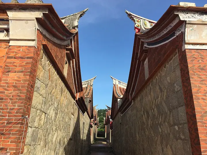
Shuitou offers a settlement-focused visit, while Zhaishan Tunnel shows a former military waterway cut into the rock. Choose one geographical cluster and check the individual site notices. Zhaishan is scheduled to close to ordinary visits on 16–18 October 2026 for the tunnel music festival.
Kinmen National Park was announced in May 1995 and its management office was established in October 1995, making it the Republic of China's sixth national park, its first on an outlying island, and its first built around protecting historical and cultural heritage and military-battle memorials alongside natural-resource conservation.
The park is divided into five zones: Taiwu Mountain (太武山) at the centre of Kinmen island, Guningtou (古宁头) in the northwest, Gugang (古岗) in the southwest, Mashan (马山) in the northeast, and Lieyu (烈屿), together covering about 3,720.7 hectares, a quarter of Kinmen County's area. Geologically the island splits along the Qionglin-Shangyi line (琼林—尚义连线) into an eastern half of exposed granite gneiss and a western half of laterite, with its northeastern, southeastern and Lieyu coasts eroded into sea cliffs and wave-cut platforms.
The subtropical maritime climate brings strong winds, an average temperature of about 21 degrees Celsius, dry winters and foggy springs; annual rainfall of about 1,000 millimetres, mostly falling between February and September, is outweighed by evaporation above 1,600 millimetres, leaving semi-arid conditions that limit agriculture. Large wildlife is scarce after early development and repeated wars, but the park shelters the endangered otter and the ancient horseshoe crab and Chinese lancelet, and is a stopover for large numbers of migratory birds each autumn and winter.
What to look for
- Zhongshanlin introduces the park’s cultural and natural themes.
- Shuitou preserves a traditional settlement connected with overseas travel.
- Zhaishan Tunnel reveals the island’s former military infrastructure.
Location & getting there
Getting to Kinmen National Park
Zhongshanlin Visitor Center is at 460, Section 2, Boyu Road in Jinning. Use it as an orientation stop, then arrange transport to the individual park sites. The map’s park pin is not an entrance that gives access to all of them.
Combine your visit
Build the visit around these complementary stops.
-
Zhongshanlin Visitor Center中山林遊客中心
Understand the park’s themes and choose an open site cluster.
-
Shuitou settlement水頭聚落
Explore the public village streets and open displays.
-
Zhaishan Tunnel翟山坑道
Add the tunnel only when its current access notice permits.
Use the current visitor programme and local conditions to choose which stops to include.
Find Kinmen National Park
金門國家公園 · 金門縣
The pin marks the area, not the entrance.
More places nearby
Approximate straight-line distances between map pins, not travel distances.
Penghu Tianhou Temple 澎湖天后宮
156 km awayPenghu Tianhou Temple stands in Magong’s historic centre and reflects the islands’ close relationship with seafaring and Mazu worship. Its layered halls contain detailed timber and stone craftsmanship. Begin at the front…
View guide →Penghu 澎湖
157 km awayPenghu is an archipelago, so a good itinerary distinguishes the road-connected main islands from destinations requiring another boat. Magong’s old streets and Tianhou Temple provide a cultural starting point. The cross-sea…
View guide →Lukang 鹿港
214 km awayLukang’s old streets preserve the scale of a trading town: decorative doorways, deep shop houses and narrow lanes reflect the merchants and shipping businesses that once gathered here. Yaolin Street is a useful place to begin…
View guide →Sources & visit information
The sources below support the place-specific description and arrival information. Suggested combinations are editorial planning ideas; confirm current opening, entry arrangements and transport services for your date.
- Tourism Administration: 翟山坑道 — attraction record Attraction_371020000A_001337 ↗
- Kinmen National Park: Zhongshanlin Visitor Center address ↗
- National Park Service: Zhongshanlin exhibitions ↗
- Kinmen County cultural authority: Zhaishan Tunnel ↗
- Chinese Wikipedia: 金門國家公園 (revision 94206446, 2026-09-05) ↗
Selected visitor facts translated and adapted from Tourism Administration and contributing local tourism authorities, 2026 Tourism Information Database v2.1 — 水頭聚落 (Attraction_371020000A_000520) · Open Government Data License 1.0.
Selected visitor facts translated and adapted from Tourism Administration and contributing local tourism authorities, 2026 Tourism Information Database v2.1 — 翟山坑道 (Attraction_371020000A_001337) · Open Government Data License 1.0.
Background paragraphs translated and condensed from Wikipedia contributors, "金門國家公園", Chinese Wikipedia · CC BY-SA 4.0. Source revision 94206446.