

Entry & permits for Tibet (Xizang)
Foreign tourists need Tibet entry approval, commonly called a Tibet Travel Permit, and an organised visit arranged through a specialist travel agency in China. Confirm your approved route before booking transport. Requirements differ for Taiwan residents and for travellers using mainland or Hong Kong/Macao Chinese resident documents; check the document guide before you book.
Check the travel-document requirements →Policy scope verified: 2026-09-06. UK FCDO: China regional travel advice ↗ State Council Taiwan Affairs Office: Tibet entry approval ↗ Xizang Department of Culture and Tourism: Medog border permit notice ↗
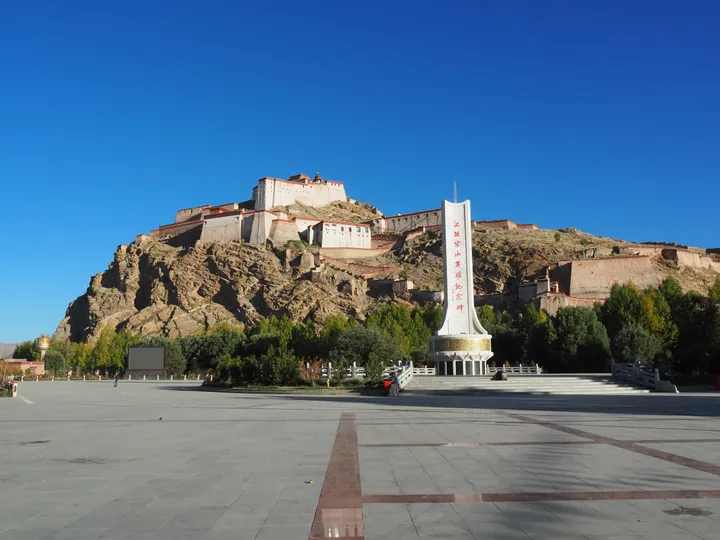
Photo adjustments
Full frame retained; proportionally resized and converted to WebP. No retouching or changes to the photographed subject. Card displays may crop the view.
Explore the region
About Gyantse Dzong Anti-British Resistance Site
Gyantse Dzong Anti-British Resistance Site (江孜宗山抗英遗址) is the ruined hilltop fortress of Gyantse (江孜), Shigatse, Tibet, where Tibetan troops and townspeople held out against a British expedition in 1904. The State Council placed it on the first national list of key cultural relic sites on 4 March 1961.
Dzong Hill (宗山) is a small rise at the heart of the old town of Gyantse, on the north bank of the Nyang Chu (年楚河); China Pictorial gives its height as 4,187 m above sea level. Gyantse sits on the route from Tsang, the western part of central Tibet, to Lhasa. In 967 Pelkhortsen (白阔赞), a descendant of the Tubo (吐蕃) kings, raised a palace-fortress on the hill to rule the Nyang Chu basin. Under the Phagmodrupa (帕竹) regime Gyantse became one of thirteen dzong (宗), fortified seats of district government. Later, under the Kashag (噶厦), two fifth-rank governors, one a monk and one a layman, ran a district of about 13,400 km² from this castle, covering present-day Gyangzê (江孜县) and Kangmar (康马县) counties and the part of Yadong County (亚东县) north of Pari Tangla Mountain (帕里塘拉山).
In 1904 a British force advanced on Gyantse, and the battle for the town lasted about 100 days, from April to July. Chinese Wikipedia records nearly 5,000 defenders fighting with matchlocks, swords, bows and slings, and seven British infantry assaults backed by artillery beaten off on 5 and 6 July. The British took the hill on 7 July, then Pelkor Chode (白居寺) and the rest of the town, before marching on Lhasa. The fortress was left in ruins. Mainland Chinese accounts say that the last defenders, out of ammunition and food, leapt from the northern cliff; foreign Tibetologists doubt this, and British records do not mention it.
A path of steps climbs from the front of the hill, and a road from the back reaches the council hall halfway up. From the top there are views over the Nyang Chu valley and Pelkor Chode. China Pictorial notes a 650 m² memorial hall on the fortress, and Heroes' Square (英雄广场) in front of the hill holds a monument to the defenders.
What to look for
- The gun emplacement, where defenders fired the "Yellow Brothers" cannon once used by the Qing general Fuk'anggan (福康安) in 1791
- The dzong government council hall (江孜宗政府议事厅), with figures recreating an office scene and old land registers on display
- The Chos-rgyal Hall (法王殿), built in the Ming dynasty and the forerunner of Pelkor Chode, with bullet holes from 1904 still visible in its murals
- The Amban border-inspection stele (驻藏大臣巡边石碑) of 1795, recording the frontier tour of the Qing residents Songyun (松筠) and Hening (和宁)
- The memorial at the cliff edge, inscribed in Chinese, Tibetan and English
- The view from the summit over the Nyang Chu valley and Pelkor Chode
Location & getting there
Getting to Gyantse Dzong Anti-British Resistance Site
- Search for 江孜宗山抗英遗址 with 日喀则市 and 江孜县.
Find Gyantse Dzong Anti-British Resistance Site
江孜宗山抗英遗址 · 江孜县
No reliable map pin yet: search by the Chinese name.
Sources & visit information
Written from the linked sources and checked sentence by sentence against quoted extracts by a separate reviewer on 2026-09-23. Opening hours, admission and access arrangements are not covered; confirm current visitor information with the site.
Some facts checked against Wikipedia contributors, "江孜宗山" · CC BY-SA 4.0.