

Photo adjustments
The exact downloaded source bytes are separately retained and hashed. Prepared JPEG is proportionally reduced to a maximum 720-pixel long edge; full frame retained, no subject alteration. Final website rendition: full frame retained, proportionally resized to at most 720 pixels and converted to WebP. No additional retouching or subject alteration. Card displays may crop the view.
Explore the region
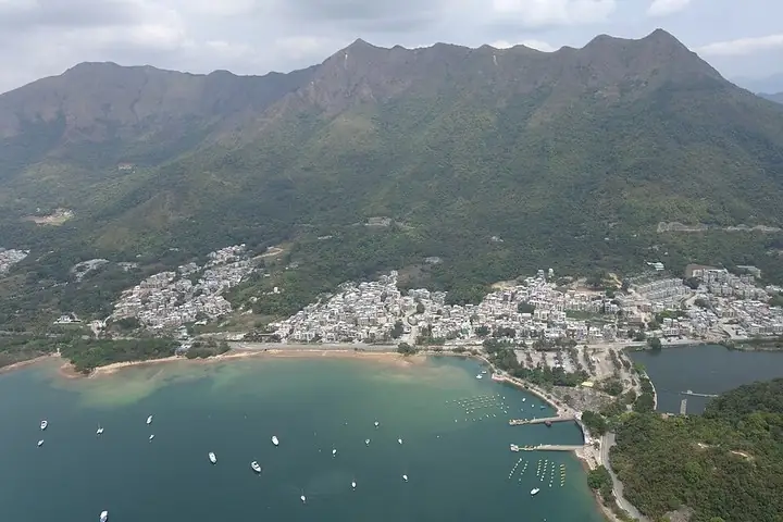
About Tai Mei Tuk
Its short Family Walk circles a small hill, with four viewpoints looking towards the reservoir, Ting Kok and the Pat Sin Leng ridge. Chinese-zodiac direction markers add a distinctive detail along the path. The dam and water are the organising features of this outing; keep the hill circuit separate from the much longer trails around the reservoir and into the mountains.
The area lies at the eastern edge of Tai Po District, at the tail end of the 'dragon vein' (龙脉) of Pat Sin Leng (八仙岭), a position whose original two-character name was read as inauspicious in Cantonese; villagers therefore came to favor euphemistic variants, and in 2007 the Lands Department formally adopted the present name by government-gazette notice, a change opposed by some residents and scholars, including a Heung Yee Kuk vice-chairman, as erasing a historically meaningful name.
Tai Mei Tuk lies beside the northern end of the Plover Cove main dam, facing south across Tolo Harbour (吐露港) towards Ma Shi Chau (马屎洲) in the distance. Several villages stand in the area, including Tai Mei Tuk Village, Ng Uk Tsuen (吴屋村), Lung Mei Tsuen (龙尾村) and Wong Chuk Tsuen (黄竹村).
What to look for
- Four viewpoints reveal the reservoir, Ting Kok and the Pat Sin Leng hills.
- Chinese-zodiac direction markers identify points along the Family Walk.
Location & getting there
Getting to Tai Mei Tuk
Arrive at Tai Mei Tuk Bus Terminus and head towards the main dam of Plover Cove Reservoir for the Family Walk entrance. The official guide identifies both bus and green-minibus services to the terminus; check the current service before travelling.
Combine your visit
Suggested order for the visit:
-
Tai Mei Tuk trail entrance
Find the signed Family Walk near the reservoir approach.
-
Reservoir-facing viewpoints
Compare the dam and water views.
-
Pat Sin Leng and Ting Kok viewpoints
Complete the short signed circuit.
This is an editorial sequence of named spaces or places. It does not imply a verified walking connection or promise opening, ticket availability or a journey time.
Find Tai Mei Tuk
大美督 · 大埔区
The pin marks the area, not the entrance.
More places nearby
Approximate straight-line distances between map pins, not travel distances.
Bride's Pool 新娘潭
4 km awayBride’s Pool Nature Trail follows a wooded valley where moving water has shaped the rock into cascades and rounded potholes. The short trail also reaches the old Bride’s Pool stone bridge, once part of the link between Wu Kau…
View guide →Tai Po Waterfront Park 大埔海滨公园
5 km awayTai Po Waterfront Park brings gardens and recreation spaces to the shore of Tolo Harbour. The Spiral Lookout Tower offers an elevated view over the water and surrounding district, while the Insect House turns attention to much…
View guide →Hong Kong Railway Museum 香港铁路博物馆
8 km awayThe Hong Kong Railway Museum occupies the old Tai Po Market station. Its pitched roof, decorated ridges and small ornamental figures give the station a distinctly southern Chinese architectural character. Preserved locomotives…
View guide →Sources & visit information
The sources below support the place-specific description and arrival information. Suggested combinations are editorial planning ideas; confirm current opening, entry arrangements and transport services for your date.
- AFCD Enjoy Hiking: Tai Mei Tuk Family Walk ↗
- Chinese Wikipedia: 大美督 (revision 94005619, 2026-08-23) ↗
Background paragraphs translated and condensed from Wikipedia contributors, "大美督", Chinese Wikipedia · CC BY-SA 4.0. Source revision 94005619.