


Get to know Tai Po District

Photo adjustments
Full frame retained; proportionally resized and converted to WebP. No retouching or changes to the photographed subject. Card displays may crop the view.
- Administrative area
- District · 地區
- Part of
- Hong Kong
- Chinese name
- 大埔
- Local areas
- District guide
Area & population
- Area in the source
- 148.05 km²
- Population · 2021
- 316,470
Source: cited geographic source, as of the dates shown.
Setting and landscape
Tolo Harbour runs southwest to northeast, east of Tai Po new town, and drains through Tolo Channel (大赤門) into Mirs Bay. Plover Cove Reservoir (船灣淡水湖), between Tai Mei Tuk (大尾篤) and the Sha Tau Kok peninsula, was the first large Hong Kong reservoir made by enclosing sea; building it in the 1960s moved six villages from the old bay shore. Pat Sin Leng forms the natural boundary with North District.
History
In 963 the Southern Han ruler Liu Chang (劉鋹) put 3,000 men to pearl-gathering in Tolo Harbour; once the beds were exhausted, an imperial order ended the harvest in the 35th year of the Kangxi reign. The Tang clan of Lung Yeuk Tau applied in 1672 to set up a market, Tai Po Hui (大步墟). In 1892 seven village alliances, the Tai Po Tsat Yeuk (大埔七約), set up a second market, Tai Wo Market (太和市), across the river. British warships landed at Tai Po in April 1899 for the flag-raising that marked the takeover of the New Territories, and the British made Tai Po the administrative centre of the new territory.
What to see
The Old Tai Po Market Railway Station (舊大埔墟火車站), completed in 1913 in Chinese style unlike the other stations on the Kowloon-Canton Railway, now houses the Hong Kong Railway Museum (香港鐵路博物館). Man Mo Temple (文武廟), opened in 1892 with donations from the Tsat Yeuk, served Tai Wo Market as a place for meetings, arbitration and worship of the gods of literature and war.
The red-brick District Office (North) (舊北區理民府) of about 1907 was the first seat of civil government in the New Territories and held a magistrate's court until 1961. At Wun Yiu (碗窰), the Man and Tse clans made blue-and-white porcelain from the Ming dynasty; the kilns closed in 1932, and digs in 1995 and 1999 found clay pits, water-mills and dragon kilns.
Food and local products
Organic vegetables are sold direct at the Tai Po Farmers' Market (大埔農墟), which began as the Tsat Yeuk produce market that was part of Tai Wo Market.
Highlights
- Hong Kong Railway Museum 香港鐵路博物館: In the Chinese-style Old Tai Po Market Railway Station of 1913.
- Man Mo Temple, Tai Po 文武廟: Opened in 1892 as the meeting place of Tai Wo Market.
- Pottery kilns at Wun Yiu 碗窰: Blue-and-white porcelain works from the Ming dynasty to 1932.
- Plover Cove Reservoir 船灣淡水湖: Hong Kong's first large reservoir created from the sea.
Sources for this guide
Old Tai Po Market Railway Station - Declared Monuments · Antiquities and Monuments Office, HKSAR Government
Man Mo Temple, Tai Po - Declared Monuments · Antiquities and Monuments Office, HKSAR Government
Pottery Kilns at Wun Yiu Village in Tai Po - Declared Monuments · Antiquities and Monuments Office, HKSAR Government
Old District Office North, Tai Po - Declared Monuments · Antiquities and Monuments Office, HKSAR Government
大埔區 - 維基百科 · Chinese Wikipedia · CC BY-SA 4.0
Original English written from the listed sources and checked sentence by sentence against quoted extracts by a separate reviewer. Updated 2026-09-25.
Explore Tai Po District
Core places to explore, with English and Chinese names.
Places to explore around Tai Po District
 Waterfall rock face at Bride’s Pool · 新娘潭瀑布岩壁 Photograph date recorded by the source: 24 January 2016, 13:16:24.
Bride's Pool新娘潭
Bride’s Pool Nature Trail follows a wooded valley where moving water has shaped the rock into cascades and rounded potholes. The short trail also reaches the old Bride’s Pool stone bridge, once part of the link between Wu Kau…
Read the place guide →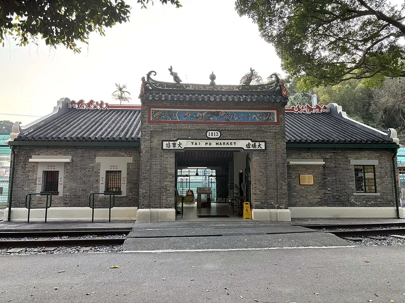 Historic station building of the Hong Kong Railway Museum · 香港铁路博物馆 Photograph date recorded by the source: 2026-02-02 17:16:10.
Hong Kong Railway Museum香港铁路博物馆
The Hong Kong Railway Museum occupies the old Tai Po Market station. Its pitched roof, decorated ridges and small ornamental figures give the station a distinctly southern Chinese architectural character. Preserved locomotives…
Read the place guide →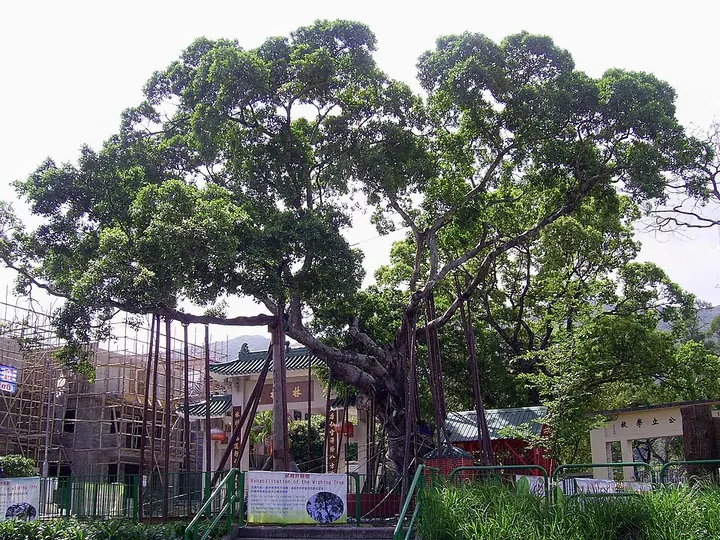 One of the Lam Tsuen Wishing Trees, photographed in 2008 · 林村许愿树(2008年) Photograph date recorded by the source: 17 April 2008.
Lam Tsuen wishing trees林村许愿树
The Lam Tsuen Wishing Trees are part of a village shrine setting beside the Tin Hau Temple in Fong Ma Po. The custom of attaching written wishes to oranges became associated with the banyan trees, especially around Lunar New…
Read the place guide →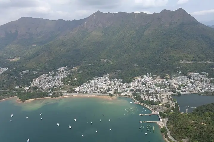 Tai Mei Tuk waterfront with Pat Sin Leng behind · 大美督海岸与八仙岭 Photograph date recorded by the source: 26 March 2014.
Tai Mei Tuk大美督
Tai Mei Tuk provides an accessible introduction to the landscape around Plover Cove Reservoir. Its short Family Walk circles a small hill, with four viewpoints looking towards the reservoir, Ting Kok and the Pat Sin Leng ridge…
Read the place guide → Tai Po Waterfront Park and lookout tower · 大埔海滨公园与回归纪念塔 Photograph date recorded by the source: 1 July 2017.
Tai Po Waterfront Park大埔海滨公园
Tai Po Waterfront Park brings gardens and recreation spaces to the shore of Tolo Harbour. The Spiral Lookout Tower offers an elevated view over the water and surrounding district, while the Insect House turns attention to much…
Read the place guide →Plan your visit
Getting there
Tai Po District is about 15 km in a straight line from central Hong Kong. Search for 大埔 in a map app to find stations and your accommodation.
Where to stay →Build your route
Bride's Pool and Hong Kong Railway Museum are about 10 km apart in a straight line. The linked place guides have entrance and visit details.
Continue with Hong Kong →More in Hong Kong
Sources & geographic information
Administrative names and parent areas: Official geographic directory · Reference date 2026-09-06.
Some facts checked against 大埔區 — Wikipedia contributors, CC BY-SA 4.0.
Photo: Bride's Pool · cattan2011 · cattan2011 — Bride's Pool, Tai Po, Hong Kong.jpg — CC BY 2.0 · CC BY 2.0. The exact downloaded source bytes are separately retained and hashed. Prepared JPEG is proportionally reduced to a maximum 720-pixel long edge; full frame retained, no subject alteration. Final website rendition: full frame retained, proportionally resized to at most 720 pixels and converted to WebP. No additional retouching or subject alteration. Card displays may crop the view.

Photo: Hong Kong Railway Museum · Tombus20032000 · CC BY-SA 4.0. Full frame retained; proportionally resized and converted to WebP. No retouching or changes to the photographed subject. Card displays may crop the view.

Photo: Lam Tsuen wishing trees · Chong Fat · Chong Fat — HK_LamTsuenWishingtree_2008.JPG — Public domain · Public domain. Full frame retained; proportionally resized and converted to WebP. No retouching or changes to the photographed subject. Card displays may crop the view.


Photo: Tai Mei Tuk · Geographer · User:Geographer · CC BY-SA 3.0. The exact downloaded source bytes are separately retained and hashed. Prepared JPEG is proportionally reduced to a maximum 720-pixel long edge; full frame retained, no subject alteration. Final website rendition: full frame retained, proportionally resized to at most 720 pixels and converted to WebP. No additional retouching or subject alteration. Card displays may crop the view.

Photo: Tai Po Waterfront Park · Wpcpey · Wpcpey — Tai_Po_Waterfront_Park_Aerial_view_201707.jpg — CC BY-SA 4.0 · CC BY-SA 4.0. The exact downloaded source bytes are separately retained and hashed. Prepared JPEG is proportionally reduced to a maximum 720-pixel long edge; full frame retained, no subject alteration. Final website rendition: full frame retained, proportionally resized to at most 720 pixels and converted to WebP. No additional retouching or subject alteration. Card displays may crop the view.

Map data © OpenStreetMap contributors. Pins mark approximate centres, not entrances or boundaries.