

Photo adjustments
Full frame retained; proportionally resized and converted to WebP. No retouching or changes to the photographed subject. Card displays may crop the view.
Explore the region
About Erlang Mountain
Seven peaks make up the massif, Jianshan, Pingshan, Aoshan, Xieshan, Liangshan, Gushan and Changlingshan, of which three, Jianshan, Pingshan and Changlingshan, have been opened up; the developed ground covers about 22 square kilometres. Forest cover is above 96 per cent and most of the trees are sawtooth oak. The area is rated AAAA, is designated a national water conservancy scenic area, and records 126 natural and cultural features. The name comes from a legend in which the god Erlang Shen carried the hills on a shoulder pole while chasing the sun.
Because the hills sit directly against the reservoir, the visiting ground divides between ridge and water. The hill line runs past the Erlang Shen square, a viewing terrace, the Yuhuang Jindian hall, the oak woods and the Longbi waterfall; the waterside line follows the shore past the Shenxiandu suspension bridge, an old plank walkway built out over the water, the Shimantan dam, Wangyou Valley and Aiqing Island. The Wugang government page gives the dam its local title as the first dam of the Huai River control programme.
What to look for
- The Yuhuang Jindian, a hall first founded in the Eastern Han, destroyed by Japanese bombing in 1941 and rebuilt on the site in 2000.
- The glass suspension bridge, 286 metres long, 2 metres wide and 148 metres high, strung between the two notches that the Erlang Shen legend calls the rests of his carrying pole.
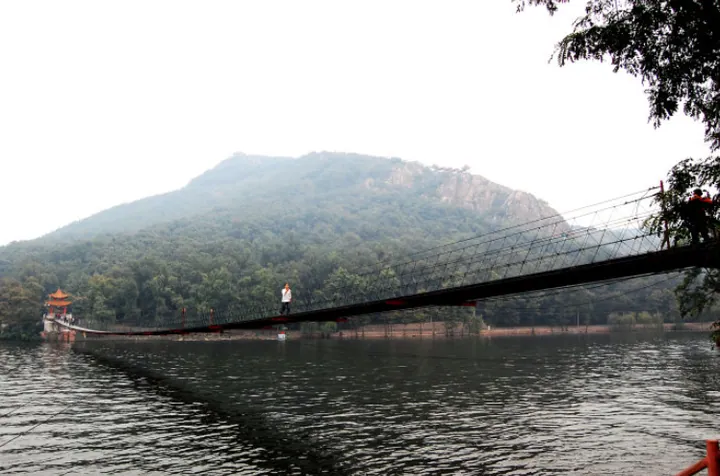
- The Shenxiandu suspension bridge, nearly 239 metres across the water, 2.5 metres wide and 6 metres above the surface, with foundations sunk 6 metres below it.
- The plank walkway carried out over the water along the reservoir shore.
- The oak woodland, largely sawtooth oak, with forest cover above 96 per cent.
- The Shimantan dam itself, at the head of the reservoir the scenic area looks out over.
Location & getting there
Getting to Erlang Mountain
Confirm the visitor entrance and which boat or walking routes operate on your date. Rainfall, water levels and weather can change access.
- Search for 二郎山 with 平顶山市 and 舞钢市.

Find Erlang Mountain
二郎山 · 舞钢市
No reliable map pin yet: search by the Chinese name.
Sources & visit information
The linked sources support the identity and background described in this introduction. Opening hours, admission, activity availability and exact arrival arrangements have not been comprehensively checked. Confirm current visitor information with the venue; the original catalogue locality and editorial review flag are retained.