

Photo adjustments
EXIF orientation normalized; resized without changing aspect ratio; converted to WebP. No subject edits.
Explore the region
About Dangling Scenic Area
A signed essay published by the Sichuan provincial local-chronicles office describes the massif as tilting from north-west to south-east and running north and south, with its main peak Xiaqiangla at 5,470 metres and twenty-eight peaks above 5,000 metres standing around it; the Tibetan name of the main peak is glossed there as 'beautiful goddess mountain'. The same essay reports a tradition that the Mongol cavalry overthrew the Western Xia more than a thousand years ago, that some Tangut people fled south through Danba and settled below a great snow mountain, and that the mountain took its name from them. The provincial government service portal's profile of Dangling village derives the name differently, from the southward migration and settlement of Dangxiang Qiang people in the Tang period; both accounts are given here as their sources state them.
More than thirty lakes lie scattered through the old forest. Huluhai, ringed by dozens of snow peaks at about 4,200 metres, is a plateau barrier lake formed after the Quaternary glaciers retreated and shaped like a gourd; fish swim in it and musk deer and other animals come down to drink at its edge. Jiayilacuo, also called Niunaihai, lies at 4,100 metres in Qimei township between Danba and Daofu, 7 km from Dangling village and about two hours from it on foot, and Zhuoyongcuo, also called Dahaizi, is Huluhai's neighbour. The essay names two hot springs about 4 km south of the village: Murichaqu, strongly sulphurous, whose Tibetan name it glosses as 'gunpowder bathing pool', and Bukachaqu, with a large lawn around it, glossed as 'lawn bathing pool'. Both run all year, reach a maximum flow of more than 3,000 tonnes a day, and leave the ground at up to 75 degrees Celsius; on analysis the water is a neutral sodium bicarbonate thermal mineral water.
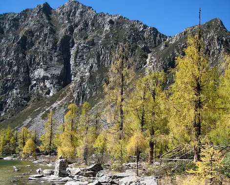
The village profile places Dangling village on valley flats among the mountains, ringed by old forest and alpine meadow in a cool, damp highland climate, and sets out a layered pattern of snow mountain, forest, meadow and lakes, with matsutake and caterpillar fungus among the local products. It records century-old Tibetan village houses, mani stone carving and old temple remains surviving in the village, and says Jiarong Tibetan custom is still practised there, the Tibetan dialect, guozhuang dancing and snow-mountain belief standing alongside one another.
What to look for
- Xiaqiangla, the 5,470-metre main peak, with the twenty-eight peaks above 5,000 metres that the essay counts around it.
- Huluhai at about 4,200 metres, a gourd-shaped barrier lake left after the Quaternary glaciers retreated, with fish in it and musk deer coming down to drink.
- Jiayilacuo, also called Niunaihai, at 4,100 metres in Qimei township, 7 km and about two hours on foot from Dangling village.
- Murichaqu and Bukachaqu, the two hot springs about 4 km south of the village, one strongly sulphurous and the other set in a large lawn, with water leaving the ground at up to 75 degrees Celsius.
- The century-old Tibetan village houses, mani stone carving and old temple remains that the village profile records in Dangling village itself.
Location & getting there
Getting to Dangling Scenic Area
Follow the currently permitted path and arrange the return before setting out. Do not infer trail continuity or difficulty from the route name alone.
- Search for 党岭 with 甘孜藏族自治州 and 丹巴县.
Find Dangling Scenic Area
党岭 · 丹巴县
No reliable map pin yet: search by the Chinese name.
Sources & visit information
The linked sources support the identity and background described in this introduction. Opening hours, admission, activity availability and exact arrival arrangements have not been comprehensively checked. Confirm current visitor information with the venue; the original catalogue locality and editorial review flag are retained.