

Explore the region
About Beishan National Forest Park
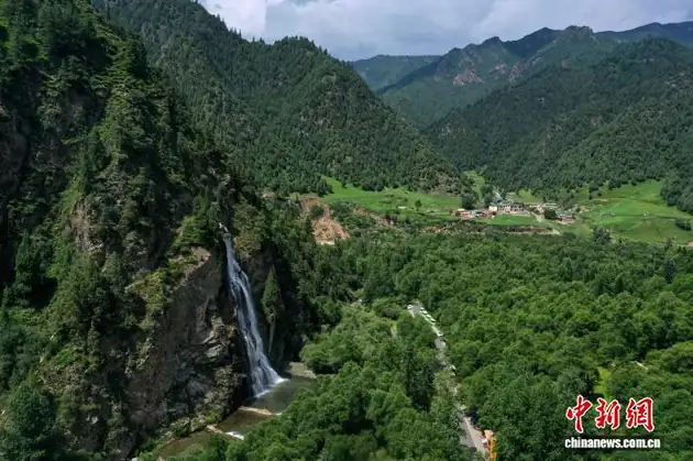
The Huzhu county government's page records that Beishan National Forest Park lies in the north-east of Huzhu Tu Autonomous County with an elevation of 2,100–4,308 m, an area of 1,127 square kilometres, forest coverage of 64.3% and a growing stock of 4.2886 million cubic metres, and that two Tibetan townships fall under it. It gives the park's distances as 220 km from Lanzhou, 110 km from Xining and 78 km from the county seat, and records that the park is used for tourism, convalescence and scientific study, that it is one of the first batch of national Mother River protection ecological education bases, that it is Qinghai's only ecological park whose main subject is forest natural scenery, and that the national tourism administration rated it an AAAA-grade tourist scenic area in 2000. The Qinghai provincial government's page records that the park was approved as a provincial forest park by the Qinghai agriculture and forestry department in July 1992 and established as a national forest park by the then Ministry of Forestry in November of that year, and describes it as a place of old trees reaching the sky, fragrant pines and cypresses, mountain flowers, deep gorges and standing cliffs. It gives the same distances from the county seat at Weiyuan township and from Xining, and describes the forest region as having magnificent mountains and rivers, deep gorges, steep banks, standing peaks and interlocking ridges with fast-flowing water at the valley floors — a mountain-and-deep-valley landform that the page attributes to the Mesozoic Yanshan movement and the Cenozoic Himalayan orogeny.
The county page records that the park's main sights include the fast Datong river with its three gorges of Kasu, Qinggang and Xiahe, the Huangyahu pass at 3,500 m and the Twelve Zodiac Bend, and that the park is made up of five sub-areas: Langshidang valley, Kasu gorge, Yuanfu Daban, Zhalong gorge and Xiahe. Langshidang valley lies in the middle of the park with an area of 5,700 hectares and, the page says, is the largest valley in the park — broad and level, with a long, strong, clear stream, dense quiet woodland and the park's prime touring belt; its mouth, formed by Longwei mountain, Qinggang gorge, Shiyang ridge and the Datong river, makes a small area of its own. Kasu gorge lies in the Datong river valley in the park's north with an area of 500 hectares and a length of 300 m, with stone peaks standing on both sides, extremely hazardous terrain and water thundering inside it. Yuanfu Daban lies in the park's south-west with an area of 700 hectares and a view over the whole forest region from the top of the pass; Zhalong gorge lies east of the park's middle with an area of 200 hectares; and Xiahe lies in the park's east with an area of 700 hectares, each with named sights. The page records that the park's plant species run to more than a thousand, the most in the province by its account, with the three famous plateau flowers of rhododendron, gentian and primrose widely distributed, and that its wild animals number 198 species, of which 139 are birds, 40 mammals, 14 fish, 3 amphibians and 2 reptiles. The provincial page adds that the park's natural forest has clear vertical vegetation bands — conifers, broadleaf forest, alpine scrub and alpine meadow — and that after the park opened to the public a guesthouse, a medicinal-spring site, car parks, walking trails and the Langshidang and Zhalong gorge waterfalls were built. The county page records that the park was rated a fourth-batch national geopark by the Ministry of Land and Resources and the Ministry of Finance in 2005 for its geological structure and landforms.
What to look for
- The five sub-areas the county page names — Langshidang valley, Kasu gorge, Yuanfu Daban, Zhalong gorge and Xiahe
- Langshidang valley, which the page calls the park's largest valley, with its long clear stream, dense woodland and the small area at its mouth formed by Longwei mountain, Qinggang gorge, Shiyang ridge and the Datong river
- Kasu gorge, 300 m long and 500 hectares in area, with stone peaks on both sides and water the page says thunders inside it
- The Datong river and the three gorges the page names on it — Kasu, Qinggang and Xiahe
- The Huangyahu pass at 3,500 m and the Twelve Zodiac Bend
- The three famous plateau flowers the page names — rhododendron, gentian and primrose — widely distributed in the park
- The vertical vegetation bands of the natural forest — conifers, broadleaf forest, alpine scrub and alpine meadow
- The Langshidang and Zhalong gorge waterfalls, built after the park opened to the public
Location & getting there
Getting to Beishan National Forest Park
Check weather, trail access and the last return service. A mountain or forest area is not one entrance, and a map’s central pin may be far from the trailhead.
- Search for 北山国家森林公园 with 海东市 and 互助土族自治县.

Find Beishan National Forest Park
北山国家森林公园 · 互助土族自治县
No reliable map pin yet: search by the Chinese name.
Sources & visit information
The linked sources support the identity and background described in this introduction. Opening hours, admission, activity availability and exact arrival arrangements have not been comprehensively checked. Confirm current visitor information with the venue; the original catalogue locality and editorial review flag are retained.
Image credits & notes (1)
- Beishan National Forest Park · 北山国家森林公园Photo: k.sina.cnResized for the web; the photo itself has not been edited.