


Get to know Mengcheng County
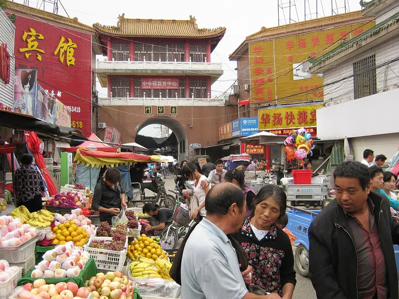
Photo adjustments
Full frame retained; EXIF orientation normalized, proportionally resized to at most 800 pixels and converted to WebP. No generated pixels or subject changes. Cards may crop the display.
- Administrative area
- County · 县
- Part of
- Bozhou
- Chinese name
- 蒙城县
- Local areas
- County guide
Area & population
- Area in the source
- 2,091.00 km²
- Population · 2015
- 1,394,994
- Administrative seat
- Chengguan
Source: cited geographic source, as of the dates shown.
History
At the end of the Warring States period the state of Chu set up Meng County (蒙县) at the old town of Meng, now Tancheng (檀城). The Western Han set up Shansang County (山桑县), which the Tang renamed Mengcheng in 742. Sima Qian's Records of the Grand Historian (史记) calls Zhuangzi a man of Meng who served as an official at Qiyuan (漆园), the "lacquer garden", and two of the county's subdistricts are named Qiyuan and Zhuangzhou (庄周). Tradition places Zhuangzi's home outside the east gate of the county town.
What to see
The Weichisi site (尉迟寺遗址) at Biji village in Xutuan town (许疃镇), the county's northernmost township, is a Neolithic settlement that specialists have called "China's first primitive village". It is assigned to a local type of the Dawenkou culture (大汶口文化). Thirteen seasons of excavation uncovered long rows of fired red-clay houses, an enclosing ditch, a ritual square and a bird-shaped sacred object. Large pottery zun jars carved with sun, moon and mountain signs were used as child coffins and ritual vessels; one pit held twelve laid end to end. Most of the finds are shown in a Weichisi gallery on the second floor of the Mengcheng Museum (蒙城博物馆). The name comes from a temple built in memory of the Tang general Yuchi Jingde (尉迟敬德).
The Wanfo Pagoda (万佛塔), built in 1102 for the now vanished Xinghua Temple (兴化寺), is an octagonal brick tower of thirteen storeys, 42.2 metres high, set with more than 8,000 Buddha images. The county says it combines northern and southern pagoda-building techniques; it has been a national key protected site since 2006. The Zhuangzi Shrine (庄子祠) goes back to 1078, when county magistrate Wang Jing (王兢) founded it and Su Shi (苏轼) wrote a record of it. Other old sites include the Confucian temple and Jiuding Lingshan Temple (九鼎灵山寺) in Langshan village, Xiaojian town (小涧镇).
Food and local products
Mengcheng yellow cattle and Mengcheng maize hold geographical-indication certification marks. Local foods include oil-crisp sesame cakes (油酥烧饼), said locally to have more than 150 years of history, and sa tang (糁汤), a soup that local legend links to the Qianlong Emperor.
Getting oriented
Bengbu, on the Beijing–Shanghai railway, and Fuyang, on the Beijing–Kowloon railway, are each about 90 km away. The Nanjing–Luoyang expressway crosses the county, and the Guo River (涡河) and the Cihuai New River (茨淮新河) carry boats to the Huai.
Highlights
- Weichisi site 尉迟寺遗址: Dawenkou culture village with rows of fired red-clay houses and carved pottery jars.
- Wanfo Pagoda 万佛塔: Thirteen-storey brick pagoda of 1102 set with more than 8,000 Buddha images.
- Zhuangzi Shrine 庄子祠: Founded in 1078; Su Shi wrote a record of it the same year.
- Mengcheng yellow cattle 蒙城黄牛: Geographical-indication certification mark.
Sources for this guide
蒙城概况-蒙城县人民政府 · Mengcheng County People's Government
蒙城县县情简介-亳州市投资促进中心 · Bozhou Investment Promotion Centre (text by the Mengcheng County Government Office)
沉睡五千年的刻画符号 揭开“中国原始第一村”面纱_中安在线 · Anhuinews (中安在线)
万佛塔 (蒙城) - 维基百科,自由的百科全书 · Wikipedia (Chinese) · CC BY-SA 4.0
蒙城县 - 维基百科,自由的百科全书 · Wikipedia (Chinese) · CC BY-SA 4.0
Original English written from the listed sources and checked sentence by sentence against quoted extracts by a separate reviewer. Updated 2026-09-23.
Explore Mengcheng County
Core places to explore, with English and Chinese names.
Mengcheng County 蒙城县
Plan your visit
Getting there
Mengcheng County is about 105 km in a straight line from central Bozhou. Search for 蒙城县 in a map app to find stations and your accommodation.
Where to stay →More in Bozhou
Sources & geographic information
Administrative names and parent areas: Official geographic directory · Reference date 2026-09-06.
Some facts checked against 万佛塔 (蒙城) — Wikipedia contributors, CC BY-SA 4.0.
Some facts checked against 蒙城县 — Wikipedia contributors, CC BY-SA 4.0.
Map data © OpenStreetMap contributors. Pins mark approximate centres, not entrances or boundaries.