

Explore the region
About Taoyuandong Scenic Area
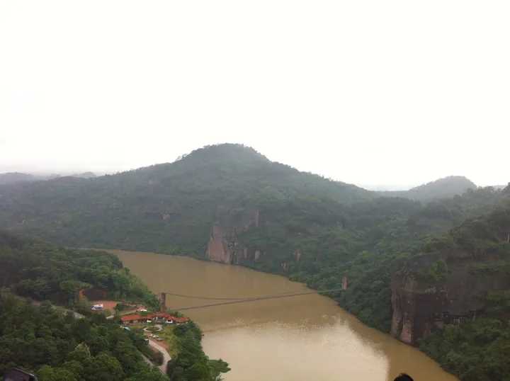
Red cliffs and wooded hills frame the river. Within the larger Taoyuan–Linyin scenic area, Taoyuan is the Danxia sector; the karst stone forest belongs to the separate Linyin sector. At Yixiantian, the rock mass opens into a deep, constricted cleft with only a thin strip of sky overhead.
The landscape also carries a history of literary naming and local patronage. In 1605, Chen Yuanzhan financed pavilions and other structures and gave the area the name Taoyuan, evoking an idyllic refuge. The large “Taoyuan Dongkou” characters on the entrance cliff remain a defining human mark on the rock scenery.
What to look for
- Yixiantian, the deep and exceptionally narrow cleft through the cliff.
- The “Taoyuan Dongkou” inscription on the red entrance cliff.
- The Shaxi River setting beneath wooded Danxia hills.
Location & getting there
Getting to Taoyuandong Scenic Area
Use an authorised visitor route. Cave sections, geological sites and access roads can close independently, so confirm the area that your ticket covers.
- Search for 桃源洞 with 三明市 and 永安市.
Find Taoyuandong Scenic Area
桃源洞 · 永安市
No reliable map pin yet: search by the Chinese name.
Sources & visit information
The linked sources support the identity and background described in this introduction. Opening hours, admission, activity availability and exact arrival arrangements have not been comprehensively checked. Confirm current visitor information with the venue; the original catalogue locality and editorial review flag are retained.
Image credits & notes (1)
- An elevated view of a river gorge: a broad muddy-brown river curving between forested hills and reddish sandstone cliffs, a slender suspension footbridge crossing the water, and a visitor area with red-roofed buildings, a road and parked cars on the near bank under a pale overcast sky.Photo: 张元柏 · CC BY-SA 3.0Resized for the web; the photo itself has not been edited. Thumbnails may show a cropped view.
