


Get to know Haicheng District
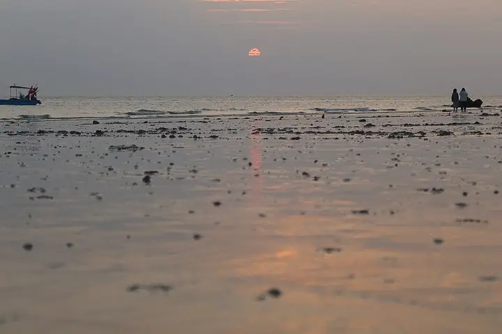
Photo adjustments
The exact downloaded source bytes are separately retained and hashed. Prepared JPEG is proportionally reduced to a maximum 720-pixel long edge; full frame retained, no subject alteration. Final website rendition: full frame retained, proportionally resized to at most 720 pixels and converted to WebP. No additional retouching or subject alteration. Card displays may crop the view.
- Administrative area
- District · 市辖区
- Part of
- Beihai
- Chinese name
- 海城区
- Local areas
- District guide
Area & population
- Area in the source
- 140.00 km²
- Population · 2020 census
- 527,895
- Administrative seat
- Zhongjie Subdistrict
Source: cited geographic source, as of the dates shown.
History
Under the Qing Daoguang emperor the area was the base of the Jinghai militia office (靖海团局) of Hepu County (合浦县). The 1876 Chefoo Convention (烟台条约) opened Beihai as a treaty port, and from 1877 eight countries, among them Britain, Germany and France, set up consulates or trading offices and built consulates, churches, hospitals, a customs house and schools in European style. Beihai left Hepu County in January 1951, and Haicheng District was created on 11 September 1984, when the communes and street offices were abolished.
What to see
Fifteen of the treaty-port buildings, collectively the Beihai modern buildings (北海近代建筑), were listed in 2001 as major national protected sites, and the former Qing post office and Hepu library were added in 2006. They include the former British, German and French consulates and the Beihai customs house (北海关大楼旧址); several now stand inside school, hotel or hospital compounds.
Haicheng's national 4A scenic areas are Underwater World (海底世界), the old town historic area (老城历史文化景区), Impression 1876 (印象·1876景区) and Gaode old town (高德古镇). The 3A list adds Nanzhu Palace (南珠宫), the Shell Carving Museum (贝雕博物馆) and the Waisha Maritime Silk Road area (外沙海丝文化景区). The district also has two designated historic and cultural blocks: Zhuhai Road–Shaji Street–Zhongshan Road (珠海路里—沙脊街—中山路历史文化街区) and Gaode Third Street (高德三街).
Weizhou and Xieyang islands
Weizhou Island lies 36 nautical miles from the Beihai urban area. It was formed by Quaternary volcanic eruptions, and its coast shows volcanic and sea-eroded landforms, with coral reefs offshore. It became the Weizhou Island Volcano National Geopark (涠洲岛火山国家地质公园) in March 2004. French Catholic missionaries completed the Shengtang village church (盛塘村天主教堂) in 1880 and the Chengzai village church (城仔村天主圣母教堂) in 1882. Weizhou town (涠洲镇), which includes Xieyang village (斜阳村), has been run by the Weizhou Island tourism area administration since 1 January 2011.
Getting oriented
The district borders Yinhai District (银海区) to the southeast and Hepu County to the north, with the sea to the northwest. The Qinzhou–Beihai Railway and the Nanning–Beihai high-speed line serve the city.
Highlights
- Beihai modern buildings 北海近代建筑: Treaty-port consulates, churches and customs house; major national protected sites since 2001.
- Old town historic area 老城历史文化景区: National 4A scenic area in Haicheng.
- Weizhou Island 涠洲岛: Volcanic island, national geopark since 2004, with 1880s Catholic churches.
- Gaode old town 高德古镇: National 4A scenic area; Gaode Third Street is a protected historic block.
Sources for this guide
海城区简介 - 海城区人民政府 · Haicheng District People's Government, Beihai
海城区旅游资源简介 - 海城区人民政府 · Haicheng District People's Government, Beihai
历史沿革 - 海城区人民政府 · Haicheng District People's Government, Beihai
行政区划 - 海城区人民政府 · Haicheng District People's Government, Beihai
涠洲岛 - 维基百科,自由的百科全书 · Wikipedia (Chinese) · CC BY-SA 4.0
北海近代建筑 - 维基百科,自由的百科全书 · Wikipedia (Chinese) · CC BY-SA 4.0
Original English written from the listed sources and checked sentence by sentence against quoted extracts by a separate reviewer. Updated 2026-09-23.
Explore Haicheng District
Core places to explore, with English and Chinese names.
Places to explore around Haicheng District
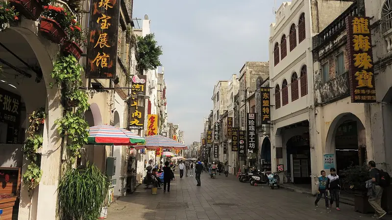 Beihai Old Street (北海老街), Haicheng District. Photograph: "北海市 百年老街 - panoramio".
Beihai Old Street北海老街
Beihai Old Street is the historic commercial area associated with Zhuhai Road, Shaji Street and Zhongshan Road.
Read the place guide →Sunset on Dishui Danping Beach, Weizhou Island · 涠洲岛滴水丹屏海滩日落 Photograph date recorded by the source: 12 February 2024, 18:28:59.Weizhou Island涠洲岛
Weizhou’s coastline exposes the meeting of volcanic rock and prolonged wave erosion. Around the island, cliffs, caves and rock platforms show how the sea has reshaped the volcanic landform; Crocodile Hill is one named area for…
Read the place guide →Plan your visit
Getting there
Haicheng District covers the centre of Beihai. Search for 海城区 in a map app to find stations and your accommodation.
Where to stay →Build your route
Beihai Old Street and Weizhou Island are both listed here. The linked place guides have entrance and visit details.
Continue with Beihai →More in Beihai
Sources & geographic information
Administrative names and parent areas: Official geographic directory · Reference date 2026-09-06.
Some facts checked against 涠洲岛 — Wikipedia contributors, CC BY-SA 4.0.
Some facts checked against 北海近代建筑 — Wikipedia contributors, CC BY-SA 4.0.
Photo: Beihai Old Street · Nyx Ning · CC BY-SA 3.0. Full frame retained; EXIF orientation normalized, proportionally resized to at most 800 pixels and converted to WebP. No generated pixels or subject changes. Cards may crop the display.

Photo: Weizhou Island · Liuxingy · Liuxingy — 日落时分的涠洲岛滴水丹屏海滩 04.jpg — CC BY-SA 4.0 · CC BY-SA 4.0. The exact downloaded source bytes are separately retained and hashed. Prepared JPEG is proportionally reduced to a maximum 720-pixel long edge; full frame retained, no subject alteration. Final website rendition: full frame retained, proportionally resized to at most 720 pixels and converted to WebP. No additional retouching or subject alteration. Card displays may crop the view.

Map data © OpenStreetMap contributors. Pins mark approximate centres, not entrances or boundaries.