


Get to know Yima
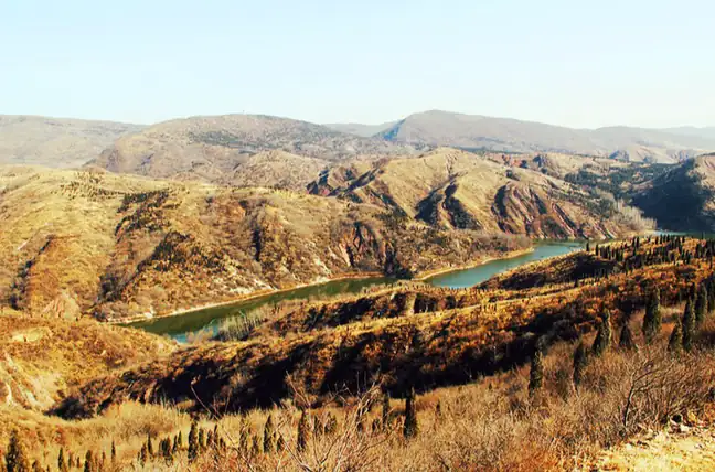
Photo adjustments
EXIF orientation normalized; resized without changing aspect ratio; converted to WebP. No subject edits.
- Administrative area
- County-level city · 县级市
- Part of
- Sanmenxia
- Chinese name
- 义马市
- Local areas
- County-level city guide
Area & population
- Area in the source
- 100.50 km²
Source: cited geographic source, as of the dates shown.
Setting and landscape
The city lies in the gullied low hills of western Henan, part of the Xiao Mountains (崤山) at the tail of the Qinling range. Ground rises to 739 metres in the north, and hills climb steeply south of the Jian River (涧河) valley. Long mining has left subsided ground, and the coal seams belong to the Yima Formation, about 180 million years old. Average temperature is 12.4°C, with 666.9 millimetres of rain a year.
History
Yima traces its administration to the Qin county of Xin'an (新安县), whose walled town stood at Xiashihe (下石河) near Ershilipu (二十里铺); its rammed-earth wall footings were located in 1998. West of Ershilipu is the Chu Pit (楚坑), where in 206 BC Xiang Yu (项羽) had 200,000 surrendered Qin soldiers buried alive; the Longhai Railway was laid through it in 1913. Yima became Henan's first county-level city in 1981 and has been administered by Sanmenxia since 1986.
What to see
The Hongqing Temple Grottoes (鸿庆寺石窟), in Shifo village (石佛村) 10 kilometres east of the city government, were cut in the Northern Wei; the temple took its name after Wu Zetian (武则天) visited in 698. Six caves survive, with 46 niches and 124 statues. The city government calls the "Subjugation of Mara" relief (降魔变) the largest of its kind found in China. The grottoes became a national key cultural relic in 2001, and Shifo is listed as a Chinese traditional village.
The Mesozoic rocks of the Yima basin hold abundant plant and animal fossils, including the "Yima ginkgo" (义马银杏), which Academician Zhou Zhiyan (周志炎) of the Nanjing Institute of Geology and Palaeontology and other Chinese and foreign specialists regard as the oldest ginkgo fossil found anywhere. The Qingfeng Mountain (清风山) scenic area in Hekou (河口) combines a forest park, Qingfeng Temple (清风寺), a lake and cherry orchards that ripen in May.
Food and local products
Farm restaurants around Qingfeng Mountain serve wild greens, free-range chicken and coarse home-made tofu. In town, the city government points to long-running shops for mipi rice-sheet noodles in red chilli oil, beef huimian (烩面) in amber beef-bone broth, sour-soup dumplings and mahua dough twists.
Getting oriented
National Highway 310 and the Lianyungang–Khorgas Expressway run through the city, the Longhai Railway stops at Yima Station, and the Zhengzhou–Xi'an high-speed line crosses it. Shifo village, in the east of the city where Yima meets Mianchi, Xin'an and Yiyang counties, is 50 kilometres from Luoyang.
Highlights
- Hongqing Temple Grottoes 鸿庆寺石窟: Northern Wei caves with 124 statues and the large Subjugation of Mara relief; national key cultural relic since 2001.
- Chu Pit site 楚坑遗址: Where Xiang Yu had 200,000 surrendered Qin soldiers buried in 206 BC.
- Yima ginkgo fossils 义马银杏化石: Mesozoic plant fossils that Zhou Zhiyan and other specialists regard as the oldest ginkgo fossils found.
- Qingfeng Mountain scenic area 清风山景区: Forest park, temple and cherry orchards that ripen in May.
Sources for this guide
义马风景名胜 · Yima Municipal People's Government
义马地理环境及自然资源 · Yima Municipal People's Government
食游义马:回味旧食光 · Yima Municipal People's Government
义马市 · Wikipedia (Chinese) · CC BY-SA 4.0
Original English written from the listed sources and checked sentence by sentence against quoted extracts by a separate reviewer. Updated 2026-09-24.
Explore Yima
Core places to explore, with English and Chinese names.
Plan your visit
Getting there
Yima is about 60 km in a straight line from central Sanmenxia. Search for 义马市 in a map app to find stations and your accommodation.
Where to stay →More in Sanmenxia
Sources & geographic information
Administrative names and parent areas: Official geographic directory · Reference date 2026-09-06.
Some facts checked against 义马市 — Wikipedia contributors, CC BY-SA 4.0.
Map data © OpenStreetMap contributors. Pins mark approximate centres, not entrances or boundaries.