

Photo adjustments
Full frame retained; proportionally resized and converted to WebP. No retouching or changes to the photographed subject. Card displays may crop the view.
Explore the region
About Chaya Mountain
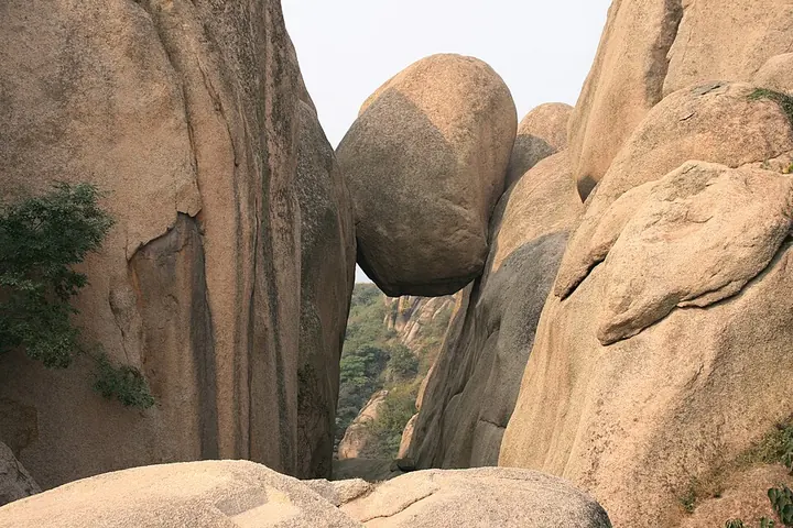
Jagged granite formations give it a markedly different appearance from a simple forested hill.
The rock peaks and irregular boulder shapes are the main subjects of a visit. The scenic name covers a broad area, so choose a managed rock-landscape route from the visitor entrance. Suiping is the relevant local approach, rather than a generic arrival anywhere in Zhumadian.
The mountain, also known as Shihou Xianshan (石猴仙山), Cuo'e Shan (嵯峨山) and Linglong Shan (玲珑山), was designated Henan's first batch of provincial-level scenic areas (省级风景名胜区) in 1987. In 876, during the Tang dynasty, it was held by the rebel leader Shang Rang (尚让), who later that year joined forces with fellow rebel leader Huang Chao (黄巢). It was designated a geopark in 2004 and later rated a national 5A tourist scenic area (国家5A级旅游景区).
Chaya Mountain is a granitic formation composed of Yanshanian granite formed 140 to 120 million years ago, with distinctive geomorphological features. The scenic area covers a total of about 148 square kilometers, with a main scenic zone of about 50 square kilometers; the peaks are locally described as resembling interlocking dog's teeth, a comparison behind the nickname 'Central Plains bonsai' (中原盆景).
What to look for
- Jagged granite peaks and interlocking rock shapes define the scenery.
- The mountain forms part of the eastern Funiu uplands.
Location & getting there
Getting to Chaya Mountain
Approach the Chaya Mountain scenic area through Suiping County, then follow the managed route from its visitor entrance.
- Confirm the selected entrance and current internal access before departure.
Combine your visit
A suggested sequence through the source-confirmed features.
-
Lower rock-landscape route
Examine Lower rock-landscape route as a separate part of Chaya Mountain.
-
Granite peak viewpoints
Jagged granite peaks and interlocking rock shapes define the scenery.
The sequence is editorial. Check local access and connections between sectors; no walking time or same-ticket access is promised.

Find Chaya Mountain
嵖岈山 · 驻马店市
The pin marks the area, not the entrance.
More places nearby
Approximate straight-line distances between map pins, not travel distances.
Xu Shen Cultural Park 许慎文化园
63 km awayXu Shen’s tomb lies near Xuzhuang village in Luohe’s Shaoling district. It commemorates the Eastern Han scholar associated with the study of Chinese characters.
View guide →Yexian County Yamen 叶县县衙
65 km awayYe County’s yamen preserves the spatial organisation of a traditional local government office. The main hall retains Ming-period fabric, while other surviving buildings largely belong to later rebuilding. Formal rooms along the…
View guide →Chunqiu Tower 春秋楼
100 km awayChunqiu Tower commemorates Guan Yu through the tradition that he read the Spring and Autumn Annals here while staying in Xuchang. The tower and monumental Guan Sheng Hall give the complex its martial focus, while an eastern…
View guide →Sources & visit information
The sources below support the place-specific description and arrival information. Suggested combinations are editorial planning ideas; confirm current opening, entry arrangements and transport services for your date.
- www.wikidata.org ↗
- 嵖岈山 ↗
- Chinese Wikipedia: 嵖岈山 (revision 93023845, 2026-06-11) ↗
- English Wikipedia: Mount Chaya (revision 1369553821, 2026-08-15) ↗
Visitor information adapted and edited from Wikipedia contributors, “嵖岈山” · CC BY-SA 4.0. Source revision 93023845.
Background paragraphs translated and condensed from Wikipedia contributors, "嵖岈山", Chinese Wikipedia · CC BY-SA 4.0. Source revision 93023845.
Background paragraphs condensed from Wikipedia contributors, "Mount Chaya", English Wikipedia · CC BY-SA 4.0. Source revision 1369553821.