

Photo adjustments
Full frame retained; proportionally resized and converted to WebP. No retouching or changes to the photographed subject. Card displays may crop the view.
Explore the region
About Tsim Sha Tsui
Begin around Salisbury Road, where the Clock Tower and Cultural Centre mark the waterfront, then follow the promenade towards the Avenue of Stars. Turning inland to Nathan Road changes the scene to hotels, shops and dense pedestrian activity. A first visit works well as one waterfront section plus a selected museum, leaving the wider shopping district for another circuit.
The name Tsim Sha Tsui first appears in the Ming-dynasty gazetteer Yue Da Ji (粤大记), in its 'Guangdong Coastal Map'. By 1819, the Xin'an County Gazetteer (新安县志) recorded a Tsim Sha Tsui Village between today's Cameron Road and Granville Road. In the early nineteenth century, foreign trading ships anchored offshore; a fatal brawl there on 7 July 1839 became one of the sparks of the First Opium War.
Before the 1960s Tsim Sha Tsui had few tourist facilities apart from the Peninsula Hotel, and shops mainly served military personnel. During the Japanese occupation the Governor surrendered at the Peninsula Hotel on 25 December 1941, after which the hotel served as the Japanese military government's headquarters. From the 1960s, Star House, Ocean Terminal and modern hotels were built and the area became a tourist district. Reclamation to the east in the 1970s created the land for Tsim Sha Tsui East, and the old Kowloon railway terminus was demolished in 1978, replaced by the Hong Kong Space Museum and Cultural Centre, with the Clock Tower kept standing.
Kimberley Street (金巴利街), known locally as 'Korea Street', has numerous Korean restaurants and food shops, while Knutsford Terrace (诺士佛台) and nearby streets, sometimes called Kowloon's Lan Kwai Fong, offer Turkish, Russian, Italian and Japanese restaurants alongside a cluster of bars on Mian Deng Jing (棉登径).
What to look for
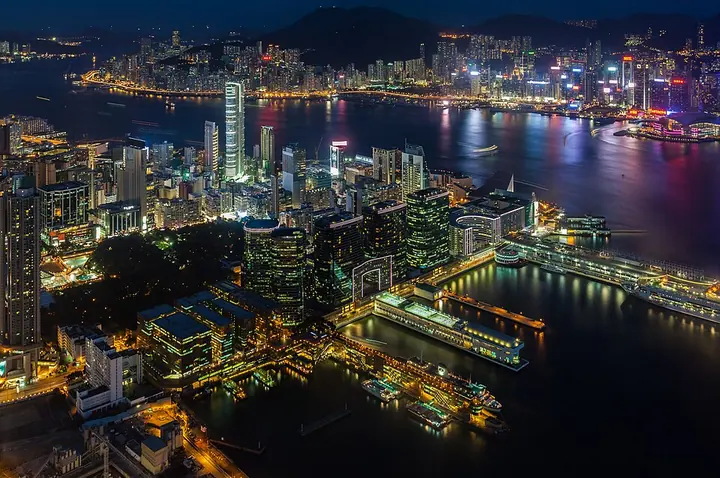
- The waterfront frames the towers and hills of Hong Kong Island across Victoria Harbour.
- The Clock Tower and nearby cultural buildings create a distinct landmark group beside Salisbury Road.
Background & history
Tsim Sha Tsui (Chinese: 尖沙咀), often abbreviated as TST, is an area in southern Kowloon, Hong Kong. The area is administratively part of the Yau Tsim Mong District. Tsim Sha Tsui East is a piece of land reclaimed from the Hung Hom Bay now east of Tsim Sha Tsui. The area is bounded north by Austin Road and in the east by Hong Chong Road and Cheong Wan Road. Geographically, Tsim Sha Tsui is a cape on the tip of the Kowloon Peninsula pointing towards Victoria Harbour, opposite Central. Several villages had been established in this location before Kowloon was ceded to the British Empire in 1860. The name Tsim Sha Tsui in Cantonese means sharp sandspit. It was also known as Heung Po Tau (香埗頭), i.e. a port for exporting incense tree. Tsim Sha Tsui is a major tourist hub in Hong Kong, with many high-end shops, bars, pubs and restaurants that cater to tourists. Many of Hong Kong's museums are located in the area.
Excerpt from Wikipedia: Tsim Sha Tsui · Wikipedia contributors · CC BY-SA 4.0. Selected introductory sentences; formatting simplified. Background information, not current visitor-service advice.
Location & getting there
Getting to Tsim Sha Tsui
Use Tsim Sha Tsui MTR station for Nathan Road or the connected East Tsim Sha Tsui station for the waterfront side. Salisbury Road and the Clock Tower provide a clear starting point; the Star Ferry also arrives at the western end of this waterfront.
Combine your visit
Suggested order for the visit:
-
Clock Tower
Start beside the former railway landmark.
-
Cultural Centre waterfront
Take in the harbour-facing public space.
-
Avenue of Stars星光大道
Continue along the eastern waterfront section.
This is an editorial sequence of named spaces or places. It does not imply a verified walking connection or promise opening, ticket availability or a journey time.
Find Tsim Sha Tsui
尖沙咀 · 油尖旺区
The pin marks the area, not the entrance.
More places nearby
Approximate straight-line distances between map pins, not travel distances.
Hong Kong Space Museum 香港太空馆
Less than 1 km awayHong Kong Space Museum is recognised by its hemispherical dome on the Tsim Sha Tsui waterfront. The dome contains the planetarium, while exhibition spaces explain astronomy and space exploration through objects, models and…
View guide →Hong Kong Museum of Art 香港艺术馆
Less than 1 km awayThe Hong Kong Museum of Art brings together Chinese antiquities, painting and calligraphy, China trade art, and modern and Hong Kong art on the Tsim Sha Tsui waterfront. Its collections make it possible to compare ceramic…
View guide →Star Ferry Pier, Tsim Sha Tsui 尖沙咀天星码头
Less than 1 km awayTsim Sha Tsui Star Ferry Pier is both a working passenger terminal and a starting point for seeing Victoria Harbour from the water. Green-and-white ferries connect this Kowloon frontage with Central and Wan Chai, giving changing…
View guide →Sources & visit information
The sources below support the place-specific description and arrival information. Suggested combinations are editorial planning ideas; confirm current opening, entry arrangements and transport services for your date.
- Hong Kong Tourism Board: City in Time Tsim Sha Tsui map ↗
- Hong Kong Tourism Board: skyline viewpoints ↗
- Tsim Sha Tsui: transport section ↗
- Chinese Wikipedia: 尖沙咀 (revision 93741278, 2026-08-02) ↗
Visitor information adapted and edited from Wikipedia contributors, “Tsim Sha Tsui” · CC BY-SA 4.0. Source revision 1367508501.
Background paragraphs translated and condensed from Wikipedia contributors, "尖沙咀", Chinese Wikipedia · CC BY-SA 4.0. Source revision 93741278.