

Explore the region
About Shiniuzhai Scenic Area
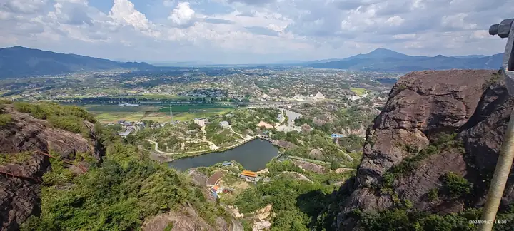
The hill itself rises to 523 metres and covers about ten square kilometres, while the Yueyang municipal government gives more than thirty square kilometres for the geopark as a whole. The rock is Danxia sandstone, and the provincial and municipal descriptions single out the way the summits weather into rounded, bun-like and ox-back shapes with marked spheroidal weathering, calling the result unusual among Chinese Danxia landscapes and rating it a national-level geological heritage feature. Named formations across the site include the Xianren Bridge, Yixiantian, Mihou Rock and Shifo Hill, and wildlife recorded here includes the pangolin and the big-headed turtle among more than fifty species.
The name refers to a fort. A stronghold existed on the hill as early as the Song dynasty, and between the late Yuan and the early Ming the local leader Tang Kuang held the mountain and added five more forts. What survives is more than six centuries of military fabric: a stone wall running for about 2,000 metres, a water fort, stone mortars, a stone gate and a drill ground, which is why the hill is known by the epithet 'first stronghold under heaven'. A group of temples stands on and below the hill, among them Baiyi Temple, Shifo Temple, Yunya Temple, Jingyan Temple and Songfeng Temple; Baiyi Temple occupies more than ten mu in two buildings and holds images of three great Buddhas, the four heavenly kings, the eighteen arhats and the twenty-four devas.
What to look for
- The well-preserved stone wall, more than 2,000 metres long
- The rounded and ox-back Danxia summits, shaped by spheroidal weathering
- Baiyi Temple, occupying more than ten mu in two buildings, with its images of the eighteen arhats and twenty-four devas
- The named rock features Xianren Bridge, Yixiantian and Mihou Rock
- The remains of the water fort, stone mortars, stone gate and drill ground
Location & getting there
Getting to Shiniuzhai Scenic Area
Use an authorised visitor route. Cave sections, geological sites and access roads can close independently, so confirm the area that your ticket covers.
- Search for 石牛寨 with 岳阳市 and 平江县.
Find Shiniuzhai Scenic Area
石牛寨 · 平江县
No reliable map pin yet: search by the Chinese name.
Sources & visit information
The linked sources support the identity and background described in this introduction. Opening hours, admission, activity availability and exact arrival arrangements have not been comprehensively checked. Confirm current visitor information with the venue; the original catalogue locality and editorial review flag are retained.
Image credits & notes (1)
- Shiniuzhai Scenic Area · 石牛寨Photo: cn.tripadvisor.comResized for the web; the photo itself has not been edited.