

Explore the region
About Huitengxile Grassland
Huitengxile Grassland (辉腾锡勒草原) is a high-mountain meadow steppe in the south-central part of Qahar Right Middle Banner (察哈尔右翼中旗), Ulanqab (乌兰察布), Inner Mongolia. It lies 75 km from Jining (集宁区), seat of the Ulanqab government, and 135 km from Hohhot (呼和浩特).
The grassland covers about 600 km² on the northern branch of the Yin Mountains (阴山) at the eastern end of the Daqing Mountains (大青山), at an average elevation of 2,100 m. Chinese Wikipedia glosses the Mongolian name as "cold plateau"; the China Meteorological Administration renders it "cool hill ridge". The Ulanqab city government gives a mean summer temperature of 18°C and describes the meadow as a relic of Quaternary glaciation, with volcanic rock spread through the hills. Lakes scattered over the grassland, called the Ninety-Nine Springs (九十九泉) since ancient times, are left over from prehistoric volcanic activity.
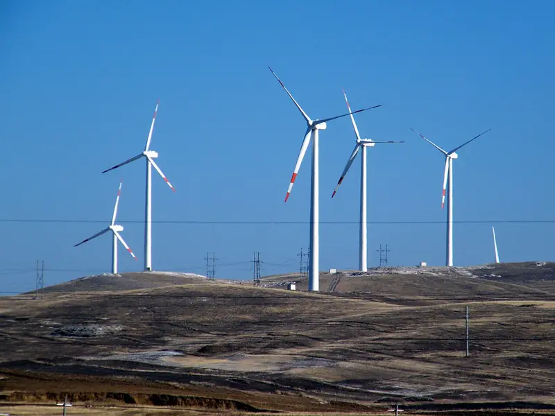
Reporting from the grassland, China Meteorological News describes weather that can change across a single hill or gully, with heavy rain in the west while the east stays clear. The climate is cold and dry with long hours of sunshine, and the plants have adapted to it: they grow low, with small leaves and a waxy coating that limits water loss; birch grows at the foot of the hills, shrubs above it and grassland higher still. The grassland also lies on the main path of the Siberian high and Mongolian cyclones into the interior, and the wind turbines spread across it form a windmill landscape over the pasture.
The Ulanqab government describes the area as a gathering and training ground for armies since ancient times and lists remains of a Zhao state wall (赵长城), Woyang City (沃阳城), Guanshan Garrison (官山卫) and beacon towers. The Huanghuagou (黄花沟) scenic area within the grassland is a national 4A-level tourist attraction. The scenic area names six core sites, and a small train, a cable car, sightseeing buses and animal-drawn carts make up a 16 km touring route; and its staged show "Meeting at the Aobao" (相会敖包) is built around aobao offerings and the Naadam (那达慕) festival.
What to look for
- Huanghuagou Flower Grassland (黄花沟鲜花草原), alpine meadow toured by a small train
- Volcanic Rock Canyon (火山奇石峡谷), an 800 m gorge of weathered granite with formations such as Jianmen Mountain (剑门山) and Shenniao Peak (神鸟峰)
- Tonghua Gully (童桦沟), with century-old tamarisks and a birch wood crossed by boardwalks
- Xiaer Qiqige Aobao (夏尔其其格敖包), a cairn whose Mongolian name means "yellow flower"
- Narisitai Forest Park (那日斯太森林公园)
- The wind turbines spread across the grassland
- Remains of the Zhao state wall (赵长城) and beacon towers (烽火台)
Location & getting there
Getting to Huitengxile Grassland
- Search for 辉腾锡勒草原 with 乌兰察布市 and 察哈尔右翼中旗.
Find Huitengxile Grassland
辉腾锡勒草原 · 察哈尔右翼中旗
No reliable map pin yet: search by the Chinese name.
Sources & visit information
Written from the linked sources and fact-checked against them on 2026-09-23. Opening hours, admission and access arrangements are not covered; confirm current visitor information with the site.
- 辉腾锡勒草原 - 维基百科,自由的百科全书 ↗
- 辉腾锡勒草原 - 景区景点 - 乌兰察布市人民政府 ↗
- 辉腾锡勒黄花沟草原旅游区游玩攻略_ 内蒙古自治区人民政府 ↗
- 探寻高山草甸辉腾锡勒的天气气候秘密-中国气象局政府门户网站 ↗
Some facts checked against Wikipedia contributors, "辉腾锡勒草原" · CC BY-SA 4.0.
Image credits & notes (1)
- Huitengxile Grassland (辉腾锡勒草原), Qahar Right Middle Banner. Photograph: "风力风电场 - panoramio".Photo: 天王星 · CC BY-SA 3.0Resized for the web; the photo itself has not been edited. Thumbnails may show a cropped view.
