

Photo adjustments
Full-frame source proportionally resized and converted to WebP for display. No subject alteration. Source-supplied marks and edits remain; cards may crop the view.
Explore the region
About Xilinhot
The monastery's courtyards contrast with the open ceremonial mound and the shopping streets around its square. Together they make an accessible introduction to the city before a longer drive onto the Xilingol grassland. Follow the temple with the hill and nearby Aobao or Ethnic Style Street, where clothing, dairy products and local craft shops connect heritage with everyday commerce.
During the Ming dynasty the area was home to descendants of Genghis Khan's elder brother, whose Mongols became known as the Abganar. After submitting to the Manchu in the seventeenth century, Abganar territory was divided into two banners, each led by a beile-rank prince. The settlement joined the newly founded Chahar Special Administrative Region in 1914, becoming part of Chahar Province in 1928, and later the Inner Mongolia Autonomous Region. It was renamed Xilinhot in 1953, then Abahanaer Banner in 1956, before being approved as a county-level city and renamed Xilinhot again in 1983.
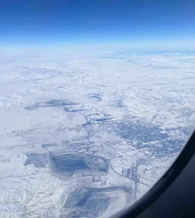
Xilinhot lies within the Xilin Gol grassland on the Inner Mongolian plateau, bordering West Ujimqin Banner to the east, Zhenglan Banner to the south, Abag Banner to the west and East Ujimqin Banner to the north. It covers 14,902 square kilometers with a population of about 110,000, mainly Han and Mongol. Terrain rises from a gently undulating northern plain to shallow southern hills, between 1,000 and 1,300 meters in elevation; Hanwula (汗乌拉), at 1,699.9 meters, is the highest point.
Every year the city holds the Naadam festival, a Mongolian summer gathering featuring wrestling, horse trading, costume contests and horse racing, with colorful yurts set up to serve food. Tapestries and monumental statues of Genghis Khan appear throughout the city, on homes, shops and street corners.
What to look for
- Beizi Temple's enclosed courts and mixed architectural traditions.
- E'erdun Aobao hill and the commercial streets surrounding Beizi Temple Square.
Location & getting there
Getting to Xilinhot
Start at Beizi Temple Square below E'erdun Aobao in northern central Xilinhot.
- The temple, hill and surrounding shopping streets form the focused urban circuit; distant grassland resorts require a separate road outing.
Combine your visit
Suggested order within this visit:
-
Beizi Temple贝子庙
Begin with the monastery around which the earlier town developed.
-
E'erdun Aobao
Continue to the hill's ceremonial setting on the open public approach.
-
Aobao or Ethnic Style Street
Finish among the nearby local-product shops.
This sequence is an editorial suggestion based on the features described in the sources. Access to individual buildings or areas should be checked locally; no travel time or shared admission is implied.
Find Xilinhot overview
锡林浩特 · 锡林郭勒盟
The pin marks the area, not the entrance.
More places nearby
Approximate straight-line distances between map pins, not travel distances.
Beizi Temple 贝子庙
2 km awayBeizi Temple stands below E'erdun Aobao hill in northern Xilinhot. Founded in 1743, the Tibetan Buddhist complex developed through successive enlargements and gave the city its former name. Its surviving halls combine Chinese…
View guide →Dali Lake 达里诺尔
83 km awayDali Lake, also called Dalinor, lies where the Gongger grassland approaches the Hunshandake sands. It is a closed saline lake with a wide horizon and important bird habitat around its margins. The southern visitor area adds the…
View guide →Hexigten Global Geopark 克什克腾世界地质公园
139 km awayHexigten Geopark is a dispersed geological landscape rather than a single enclosed park. Its best-known formations include the horizontally layered granite towers of Arshihaty and the rounded rock basins at Qingshan, with…
View guide →Sources & visit information
The sources below support the place-specific description and arrival information. Suggested combinations are editorial planning ideas; confirm current opening, entry arrangements and transport services for your date.
- Wikipedia: 锡林浩特市 ↗
- Xilinhot government: Beizi Temple and E'erdun Aobao ↗
- Xilinhot official street-area inventory: Beizi square and adjoining shopping streets ↗
- English Wikipedia: Xilinhot (revision 1373936935, 2026-09-08) ↗
Visitor information adapted and edited from Wikipedia contributors · CC BY-SA 4.0. Source revision 93132937.
Background paragraphs translated and condensed from Wikipedia contributors, "锡林浩特市", Chinese Wikipedia · CC BY-SA 4.0. Source revision 93132937.
Background paragraphs condensed from Wikipedia contributors, "Xilinhot", English Wikipedia · CC BY-SA 4.0. Source revision 1373936935.