

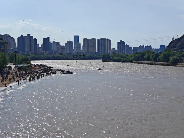
Photo adjustments
Full frame retained; proportionally resized and converted to WebP. No retouching or changes to the photographed subject. Card displays may crop the view.
Explore the region
About Yellow River Scenic Belt and Zhongshan Bridge
The two sources on the bridge agree on its broad history and differ on its details. The China Tourism News says Zhongshan Bridge was built in 1907, is 234 metres long and 7.5 metres wide, was first named the Lanzhou Yellow River Iron Bridge, was renamed Zhongshan Bridge in 1928 and is also called the Yellow River's First Bridge. The article published on the Gansu Provincial Cultural Relics Bureau's website places the decision to build it in the Guangxu reign of the Qing, when the Gansu foreign-affairs bureau decided to bring in foreign technology to improve transport around Lanzhou and links between the north-west and the interior; it says work began in the 34th year of Guangxu, 1908, and that the bridge opened to traffic in August of the first year of Xuantong, 1909. It also gives the bridge as 233.5 metres long overall and 8.36 metres wide, on four piers and five spans of 45.9 metres each, and records the 1928 naming as a commemoration of Sun Yat-sen. The two therefore differ on the construction year and on the dimensions, and both are reported here as the two publications give them.
The same article names the people and firms involved: the Lanzhou circuit official Peng Yingjia and other local officials in charge, the American engineer Man Baoben as designer, the German firm Tailai and its manager Kexiusi as contractors, and the Chinese worker Liu Yongqi leading the team of craftsmen. It records that in 2004 the bridge ended its history of carrying traffic and became a pedestrian bridge, and that in 2006 it was listed as a national key cultural relic protection unit. The China Tourism News notes that more than ten bridges have since been built in the Lanzhou urban area, so Zhongshan Bridge is no longer the only crossing of the Yellow River between north and south, and that the municipal government has improved and beautified the bridge and the banks around it, building green space, parks, walking paths and commercial streets on either side. It describes the bridge as having become a Lanzhou landmark and a popular photo spot.
The corridor's name is traced in a historical feature republished on the Gansu Belt and Road portal, which describes Lanzhou as the only provincial capital the Yellow River runs through. The feature records that in June 1951, under the head of the municipal construction section, Ren Zhenying, the draft Lanzhou urban construction plan for 1951 to 1958 was completed, and that in its designated scenic areas it proposed a riverside scenic road 50 to 100 metres back from the south bank, with small riverside parks at suitable points and a ban on public and private buildings there. It says the name 风致, meaning flavour and delight, is where the Yellow River Scenic Line's name comes from. A preliminary master plan produced in September 1954 with the participation of Soviet experts and the central urban design institute was formally approved by the national construction commission at the end of that year.
The same feature sets out how the corridor was planted and furnished. After Lanzhou's north city wall was demolished in 1958 and the south riverside road widened, the road was first planted with black locust, elm-leaved pear, honeysuckle and forsythia along with flowering shrubs brought from Xinglong Mountain and Qidaoliang; by the 1970s 60,000 square metres of flower beds and more than 3,300 square metres of walking paths had been laid out, with further ornamental trees. In the 1980s garden-within-garden areas were made with sculpture groups and garden pieces including the Yellow River Mother, Green Hope, Wild Geese Alighting on Sand and Fighting the Waves. In the 1990s the south riverside road was extended and the north one built, and after 2000 the whole Yellow River Scenic Line big scenic area was planned and built. The feature also says the corridor was named one of China's Yellow River 50 Scenes at the China Yellow River Tourism Conference in 2018, which is a listing rather than a ranking.
None of the three sources gives opening hours, access points or any statement of which buildings in the corridor can be entered, and the entry is a district-scale corridor rather than a single gated site, so the catalogue's own caution that not every building in the area can be entered stands. The historical feature is a newspaper article republished by a provincial government portal rather than an official designation record, and the Cultural Relics Bureau page is a state-media article credited to a broadcaster and republished by the bureau rather than the bureau's own listing. No source reached in this round gives the bridge's or the corridor's current management arrangements.
What to look for
- Zhongshan Bridge itself, the iron bridge the sources describe as standing on four piers with five spans of 45.9 metres
- The green space, parks and walking paths built on both banks around the bridge
- The riverside sculpture group on the south bank, including the Yellow River Mother, Green Hope, Wild Geese Alighting on Sand and Fighting the Waves
- The riverside road that Lanzhou's 1951 city plan first set out, which the corridor along the south bank now follows
Location & getting there
Getting to Yellow River Scenic Belt and Zhongshan Bridge
Choose a precise starting address and return transport stop. Access to individual buildings, performances or viewing platforms is separate from access to public streets.
- Search for 黄河风情线与中山桥 with 兰州市 and 城关区.
Find Yellow River Scenic Belt and Zhongshan Bridge
黄河风情线与中山桥 · 城关区
No reliable map pin yet: search by the Chinese name.
Sources & visit information
The linked sources support the identity and background described in this introduction. Opening hours, admission, activity availability and exact arrival arrangements have not been comprehensively checked. Confirm current visitor information with the venue; the original catalogue locality and editorial review flag are retained.