

Photo adjustments
Full frame retained; proportionally resized and converted to WebP. No retouching or changes to the photographed subject. Card displays may crop the view.
Explore the region
About Zhagana
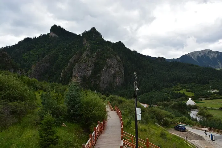
The setting becomes clearer as you move between the inhabited lanes and the designated viewpoints: the houses and cultivated terraces are as much part of the scene as the rock walls. Dari viewpoint and Xiannü Tan offer different angles on this landscape. Keep the village visit distinct from any longer mountain trek requiring additional planning.
Zhagana (扎尕那) is a village in Yiwa town, Diebu County, in the Gannan Tibetan Autonomous Prefecture. The name is a transliteration of a Tibetan term meaning 'stone box'. In the summer of 1925 the explorer Joseph Rock (约瑟夫·洛克) collected plant specimens in Diebu; he was the first Westerner to explore the Gannan area and to collect botanical and zoological specimens and map Diebu, and he recorded impressions of a monastery, Lasang Si (拉桑寺), below the mountainside, a village of closely set houses with terraced wheat and barley fields, and, behind them, limestone mountains covered with spruce and fir.
What to look for
- The limestone walls rising above the houses and cultivated terraces.
- The basin views from Dari viewpoint and the Xiannü Tan area.
Location & getting there
Getting to Zhagana
Travel from Diebu county town to Zhagana in Yiwa Town by an arranged road transfer. Confirm the visitor-centre and village access arrangements, then use the authorised links between viewpoints rather than assuming the mountain paths form a short loop.
Combine your visit
A suggested order for the documented features and stops.
-
Village lanes
Begin with the houses and fields beneath the surrounding cliffs.
-
Dari viewpoint
Read the basin and village pattern from a higher vantage point.
-
Xiannü Tan
Add a different view of the mountain enclosure using the current authorised route.
This is an editorial sequence. Check access and any road or boat transfers; it does not establish a walking route, common ticket or guaranteed same-day connection.

Find Zhagana
扎尕那 · 甘南州
The pin marks the area, not the entrance.
More places nearby
Approximate straight-line distances between map pins, not travel distances.
Langmusi 郎木寺
53 km awayLangmusi occupies a high valley at the headwaters of the Bailong River, with monastery buildings rising on both sides of the provincial boundary. The Gansu side is associated with Sertri, or Saichi, Monastery; Kirti, or Ge’erdi…
View guide →Dangzhou Grassland Scenic Area 当周草原景区
84 km awayDangzhou Grassland combines an open meadow setting with developed visitor facilities on the southern edge of Hezuo. A Tibetan-style entrance decorated with auspicious motifs introduces paths, viewpoints and white-stupa features…
View guide →Milarepa Pavilion 米拉日巴佛阁
89 km awayMilarepa Pavilion is a tall, red-walled religious building within the Hezuo monastery precinct. Its vertically arranged shrines bring together figures associated with different Tibetan Buddhist traditions, while paintings and…
View guide →Sources & visit information
The sources below support the place-specific description and arrival information. Suggested combinations are editorial planning ideas; confirm current opening, entry arrangements and transport services for your date.
Visitor information adapted and edited from Wikipedia contributors, “扎尕那” · CC BY-SA 4.0. Source revision 93757679.
Background paragraphs translated and condensed from Wikipedia contributors, "扎尕那", Chinese Wikipedia · CC BY-SA 4.0. Source revision 93757679.