

Photo adjustments
Wikimedia thumbnail; fitted to the ranking-card frame.
Explore the region
About Mount Tai
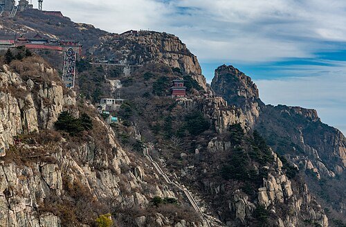
Near the upper mountain, Nantianmen marks a dramatic transition into the summit precinct. Bixia Shrine honours the mountain goddess, and Jade Emperor Peak rises farther along the crest. The landscape rewards attention to the carved words and religious buildings as much as the distant view; cloud and weather make sunrise only one possible part of a visit.
Mount Tai's rock strata are ancient, composed of mixed rock, mixed granite and gneiss dating back roughly 2.4 to 2.5 billion years. The area was once part of a large subsiding sea trough; repeated uplift and erosion were followed by renewed folding and rapid uplift in the late Mesozoic, as the Pacific plate pressed against the Eurasian plate, producing the mountain's present outline by about 30 million years ago.
Mount Tai was among the first group of national-level scenic areas designated in China and was inscribed as a UNESCO World Heritage Site in 1987 for both its cultural and natural values, meeting seven of the ten evaluation criteria and tying with the Tasmanian Wilderness in Australia for the most criteria met by any World Heritage Site. More than 1,800 stone inscriptions survive on the mountain, including over 800 stelae and more than 1,000 cliff carvings.
According to legend, Mount Tai formed from the head of Pangu (盘古) after his death. An earthquake near Mount Tai in 1831 BC or 1652 BC, first recorded in the Bamboo Annals (今本竹书纪年), is recognized by most scholars as the earliest recorded earthquake in Chinese history. In 1935 the meteorologist Zhu Kezhen (竺可桢) established China's first permanent high-altitude weather station on Riguan Peak (日观峰), with its dedication inscription written by Cai Yuanpei (蔡元培).
What to look for
- Nantianmen, the gateway into the upper pilgrimage landscape.
- Bixia Shrine and the summit setting around Jade Emperor Peak.
The surrounding area
A separate provincial base for Mount Tai, with mountain logistics distinct from a Jinan city day.
Location & getting there
Getting to Mount Tai
Choose Hongmen for the traditional walking ascent or Tianwaicun, at the north end of Longtan Road, for the scenic-bus approach to Zhongtianmen. From Zhongtianmen, continue by the available cableway or the steep walking route. Match the entrance to your booking and return plan.
Combine your visit
A suggested sequence linking the specific features of this visit.
-
Nantianmen
Enter the upper mountain through its landmark gateway.
-
Bixia Shrine
See the principal shrine associated with the mountain goddess.
-
Jade Emperor Peak
Continue to the summit precinct and its mountain outlook.
This order is editorial. Confirm access and any transfers between stops; it does not establish a walking route, same-day connection or common admission ticket.
Find Mount Tai
泰山 · 泰安市
The pin marks the area, not the entrance.
More places nearby
Approximate straight-line distances between map pins, not travel distances.
Dai Temple 岱庙
7 km awayDai Temple stands in Tai’an’s urban foothills as the main architectural counterpart to Mount Tai. The central Tiankuang Hall is roofed in yellow glazed tiles and contains a large mural of the mountain deity’s procession and…
View guide →Lingyan Temple 济南灵岩寺
17 km awayLingyan Temple lies in the hills of Changqing, where a major Buddhist complex survives around halls, a pagoda and a burial stupa forest. The Thousand Buddha Hall is especially known for its painted arhat figures, whose varied…
View guide →Thousand Buddha Mountain 千佛山
43 km awayThousand Buddha Mountain rises above southern Jinan with Buddhist carvings cut into its northern slopes. Xingguochan Temple stands partway up the hill, and the cliff behind it retains Sui-period images and small caves. Nearby…
View guide →Sources & visit information
The sources below support the place-specific description and arrival information. Suggested combinations are editorial planning ideas; confirm current opening, entry arrangements and transport services for your date.
- Mount Tai ↗
- tsgw.taian.gov.cn ↗
- whlyj.taian.gov.cn ↗
- Chinese Wikipedia: 泰山 (revision 93434320, 2026-07-12) ↗
- English Wikipedia: Mount Tai (revision 1371973342, 2026-08-29) ↗
Visitor information adapted and edited from Wikipedia contributors, “Mount Tai” · CC BY-SA 4.0. Source revision 1371973342.
Background paragraphs translated and condensed from Wikipedia contributors, "泰山", Chinese Wikipedia · CC BY-SA 4.0. Source revision 93434320.
Background paragraphs condensed from Wikipedia contributors, "Mount Tai", English Wikipedia · CC BY-SA 4.0. Source revision 1371973342.