

Photo adjustments
Wikimedia thumbnail; fitted to the ranking-card frame.
Explore the region
About Xitang
The narrow Shipi Lane contrasts with those open waterside walks, compressing the view between high residential walls. Zui Garden offers another small-scale setting of courts, rockwork and a tiny brick bridge. Choose these different spatial experiences rather than following only the busiest shopping streets. The town remains a community as well as a managed attraction, with individual houses and gardens having separate access arrangements.
The settlement lay near the boundary between the states of Wu and Yue during the Spring and Autumn period. Its older names include Xietang (斜塘), Pingtang (平塘) and Xutang (胥塘). According to local tradition, the last name recalls Wu Zixu, who ordered canals and a pond excavated to carry water and improve transport.
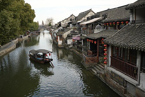
The town received national Historic Town designation on 8 October 2003 and national 5A tourist-site status in February 2017. Its network contains 122 lanes, including five longer than one hundred metres. The covered corridors extend for nearly one thousand metres and are mostly constructed from brick and wood under black-tiled roofs; long benches occupy some of the riverside sections.
What to look for
- Covered riverside corridors connect the canal banks with shops and resting places.
- Shipi Lane squeezes between high residential walls, while Zui Garden contains compact courts and rockwork.
Location & getting there
Getting to Xitang
Approach the Xitang scenic-area visitor address at 258 Nanyuan Road in Jiashan, then continue into the historic lanes on the public visitor route.
Combine your visit
A suggested sequence linking the specific features of this visit.
-
Covered riverside corridors
Begin with the town’s characteristic roofed canal walks.
-
Shipi Lane
Compare the open water edge with a narrow passage between residences.
-
Zui Garden
Finish with the small courtyard-and-rockery composition if open.
This order is editorial. Confirm access and any transfers between stops; it does not establish a walking route, same-day connection or common admission ticket.
Find Xitang
西塘 · 嘉兴市
The pin marks the area, not the entrance.
More places nearby
Approximate straight-line distances between map pins, not travel distances.
Yuehe Street 月河历史街区
24 km awayYuehe is a restored commercial neighbourhood around canals connected with Jiaxing’s old moat. Its shop and workshop buildings give the district a different character from the city’s grand private houses: narrow trading fronts…
View guide →Citadel of Jiaxing 嘉兴子城遗址
25 km awayJiaxing’s Zicheng marks the fortified administrative core of the old city. Its surviving gate, drum tower and flanking wall preserve a fragment of a much larger compound; the present gate structure dates from rebuilding in 1908…
View guide →South Lake (Jiaxing) 南湖
25 km awayJiaxing’s South Lake combines a central-island garden with the commemoration of the Communist Party’s first congress. Misty Rain Tower occupies the island formed through historical dredging, while the Red Boat nearby is a later…
View guide →Sources & visit information
The sources below support the place-specific description and arrival information. Suggested combinations are editorial planning ideas; confirm current opening, entry arrangements and transport services for your date.
Visitor information adapted and edited from Wikipedia contributors, “Xitang” · CC BY-SA 4.0. Source revision 1331220527.
Background paragraphs condensed from Wikipedia contributors, "Xitang", English Wikipedia · CC BY-SA 4.0. Source revision 1331220527.