

Entry & permits for Tibet (Xizang)
Foreign tourists need Tibet entry approval, commonly called a Tibet Travel Permit, and an organised visit arranged through a specialist travel agency in China. Confirm your approved route before booking transport. Requirements differ for Taiwan residents and for travellers using mainland or Hong Kong/Macao Chinese resident documents; check the document guide before you book.
Check the travel-document requirements →Policy scope verified: 2026-09-06. UK FCDO: China regional travel advice ↗ State Council Taiwan Affairs Office: Tibet entry approval ↗ Xizang Department of Culture and Tourism: Medog border permit notice ↗
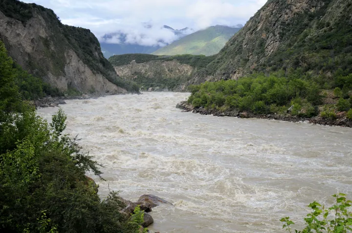
Photo adjustments
Full frame retained; proportionally resized and converted to WebP. No retouching or changes to the photographed subject. Card displays may crop the view.
Explore the region
About Yarlung Tsangpo Grand Canyon
The visitor area near Pai introduces this enormous canyon through selected viewpoints; it does not provide access through its entire length. On the south bank, the approved sightseeing route runs from the visitor centre towards Zhibai. Follow that coherent route to compare the river valley with the rising mountain walls.
The canyon carries the Yarlung Tsangpo (雅鲁藏布江) for 504.6 kilometres, with a maximum depth of 6,009 metres and an average depth of about 2,268 metres. After flowing east for about 1,700 kilometres, the river turns northeast at Pai (派镇) in Mainling County (米林县), then bends southwest around Namcha Barwa (南迦巴瓦峰). It cuts through the Himalayas and leaves the mountains at Baxika (巴昔卡村) in Medog County (墨脱县). The canyon entrance at Pai lies at 2,910 metres, while the exit at Baxika is at 155 metres.
Indian Ocean monsoons bring annual rainfall of 4,500 to 11,060 millimetres. The canyon's climate ranges from subtropical to Arctic across several vegetation zones, including lowland tropical forest, subalpine coniferous forest, alpine shrubland and tundra. Along more than twenty kilometres of uninhabited river between Xixingla (西兴拉) and the confluence with the Palong Zangbu (帕隆藏布), the riverbed drops through four groups of large waterfalls, some with falls of thirty to thirty-five metres. An American expedition found the Zangbu Badong Waterfall Group (藏布巴东瀑布群) in 1998. The canyon contains the Yarlung Tsangpo Grand Canyon Nature Reserve (雅鲁藏布大峡谷自然保护区).
What to look for
- The river’s deeply incised valley and the sharp transition from forested slopes to high mountains.
- The Zhibai side’s open viewpoints towards the Namcha Barwa mountain setting.
The surrounding area
Eastern valleys, lakes and canyon scenery around Basum Tso and the Yarlung Zangbo.
Location & getting there
Getting to Yarlung Tsangpo Grand Canyon
Begin at the Grand Canyon visitor centre in the Pai area of Milin and confirm the south-bank route towards Zhibai.
- The operator limits sightseeing services to approved routes and formally open areas; the remote canyon interior is outside this visit.
Combine your visit
Suggested order for this visit:
-
Visitor-centre orientation
Choose the open south-bank route and confirm its transport arrangement.
-
South-bank river viewpoints
Follow the valley’s shape along the designated stops.
-
Zhibai viewing area
Finish with the mountain and river setting at the end of this approved route.
This is an editorial sequence based on the features described in the sources. Confirm access locally; no walking time, shared admission or guaranteed interior access is implied.

Find Yarlung Tsangpo Grand Canyon
雅鲁藏布大峡谷 · 林芝
The pin marks the area, not the entrance.
More places nearby
Approximate straight-line distances between map pins, not travel distances.
Namcha Barwa 南迦巴瓦峰
12 km awayNamcha Barwa rises inside the great bend of the Yarlung Tsangpo, opposite Gyala Peri across the gorge. The contrast between its snow-covered summit and the much lower forested valley gives the mountain its exceptional visual…
View guide →Lulang Forest Viewpoint 鲁朗林海观景台
23 km awayLulang Forest Viewpoint looks down from the Sejila mountainside into a deep forested valley. Conifers form the main texture of the view, with snow-covered peaks, clouds and seasonal rhododendrons changing its appearance. This is…
View guide →Lulang International Tourism Town 鲁朗国际旅游小镇
24 km awayLulang’s tourism town is arranged around Zhatang Lhamo Lake, with hotels, guesthouses and a commercial street beneath the forested mountains. Its modern visitor facilities sit within a valley already known for village…
View guide →Sources & visit information
The sources below support the place-specific description and arrival information. Suggested combinations are editorial planning ideas; confirm current opening, entry arrangements and transport services for your date.
- Wikipedia: Yarlung Tsangpo Grand Canyon ↗
- Grand Canyon operator: approved south-bank visitor centre–Zhibai route ↗
- Chinese Wikipedia: 雅鲁藏布大峡谷 (revision 94134701, 2026-09-01) ↗
- English Wikipedia: Yarlung Tsangpo Grand Canyon (revision 1372332678, 2026-08-31) ↗
Visitor information adapted and edited from Wikipedia contributors · CC BY-SA 4.0. Source revision 1372332678.
Background paragraphs translated and condensed from Wikipedia contributors, "雅鲁藏布大峡谷", Chinese Wikipedia · CC BY-SA 4.0. Source revision 94134701.
Background paragraphs condensed from Wikipedia contributors, "Yarlung Tsangpo Grand Canyon", English Wikipedia · CC BY-SA 4.0. Source revision 1372332678.