

Entry & permits for Tibet (Xizang)
Foreign tourists need Tibet entry approval, commonly called a Tibet Travel Permit, and an organised visit arranged through a specialist travel agency in China. Confirm your approved route before booking transport. Requirements differ for Taiwan residents and for travellers using mainland or Hong Kong/Macao Chinese resident documents; check the document guide before you book.
Check the travel-document requirements →Policy scope verified: 2026-09-06. UK FCDO: China regional travel advice ↗ State Council Taiwan Affairs Office: Tibet entry approval ↗ Xizang Department of Culture and Tourism: Medog border permit notice ↗
Explore the region
About Nanyi Valley
The municipal government's scenic-spot entry works through the gully's named features. It places 扎贡沟原始森林 in 扎贡沟 in the township, seven kilometres from the county seat, with a forest area of 820 hectares, annual precipitation of about 675 millimetres, a mean annual temperature of 8.2 degrees Celsius and more than 720 seed-plant species. The plants it names by way of example include 米林杨, 红柄柳, 米林繁缕, 米林乌头, 米林翠雀花, 米林小檗, 米林黄芪, 米林凤仙花, 米林五加, 米林虎耳草, 米林杜鹃, 藏布杜鹃 and 西藏箭竹宽柱鸢, and it notes other plants of economic value from which scent can be extracted.
The same entry gives measurements for a single tree. The spruce king (千年云杉王) standing in 扎贡沟 has a breast-height diameter of 298.4 centimetres, a height of 56.8 metres and a crown area of 304 square metres; the entry identifies it as a variety of Lijiang spruce and calls it the thickest spruce yet measured in the gully. The entry also describes 甘露洞, a natural cave on the northern mid-slope of 扎贡沟 where water drips from crevices in the rock and freezes into ice columns in winter, names a 酥油石 and a 听经洞 inside it, and records a tradition that the cave is where Yutog Yontan Gonpo, the founder of Tibetan medicine, practised and taught.
The Lhoba presence is documented separately. The municipal entry says the Lhoba are China's second-smallest ethnic minority, officially confirmed in 1965, that they have lived for generations in the Luoyu area of Tibet, that 珞巴 means 'southerners', and that 南伊珞巴民族乡 was formally established in June 1988. A 2018 People's Daily report carried by Xinhua Net, written from Qionglin village at the deepest point of the gully, records that the 南伊沟 scenic area opened in 2010, and that the place had earlier been known as a felling gully, with the trees on the hillside behind the village largely cut away some thirty years before the 2018 account and the 南伊 river running muddy with timber lorries in the village.
Two cautions about this record's scope. It carries no ranking of the Lhoba by population, because the Mainling city entry calls them China's second-smallest ethnic minority while the People's Daily report calls them China's smallest, and the record does not adjudicate between them. And no cited source gives the gully's total area, its elevation or any viewpoint inside it; the 820 hectares and the 720 species are the municipal entry's figures for 扎贡沟, not for the whole of 南伊沟.
What to look for
- The spruce king in 扎贡沟, which the municipal government measures at 298.4 centimetres breast-height diameter, 56.8 metres tall and 304 square metres of crown
- 甘露洞, the natural cave the municipal government places on the northern mid-slope of 扎贡沟, with its 酥油石 and 听经洞
- The seed plants the municipal government lists for 扎贡沟, among them 米林杨, 米林繁缕, 米林杜鹃 and 藏布杜鹃
- Qionglin village, at the deepest point of the gully, where the People's Daily report was written
- The hillside behind Qionglin village, which the People's Daily report says was largely cut bare some thirty years before its 2018 account, when the gully was known as a felling gully
Location & getting there
Getting to Nanyi Valley
Check the open visitor route and follow the site’s rules on distance, food and photography. Conservation areas may limit access beyond designated paths.
- Search for 南伊沟 with 林芝市 and 米林市.

Find Nanyi Valley
南伊沟 · 米林市
No reliable map pin yet: search by the Chinese name.
Sources & visit information
The linked sources support the identity and background described in this introduction. Opening hours, admission, activity availability and exact arrival arrangements have not been comprehensively checked. Confirm current visitor information with the venue; the original catalogue locality and editorial review flag are retained.
Image credits & notes (1)
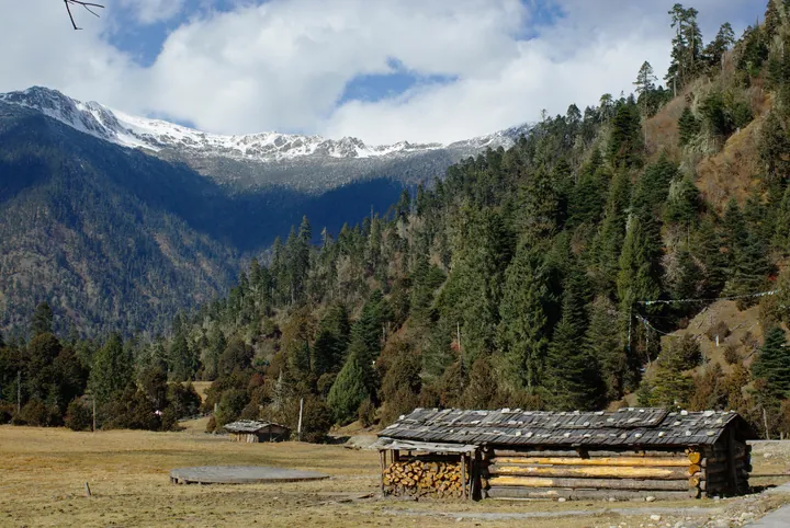
- Snow-capped peaks and forested slopes above wooden cabins in Nanyi Valley, Mainling (Nyingchi) · 林芝米林南伊沟雪山森林与木屋Photo: JL Cogburn · CC BY-SA 2.0 · taken 2012-12-01Resized for the web; the photo itself has not been edited. Thumbnails may show a cropped view.
.jpg)