

Photo adjustments
Proportionally resized and converted to WebP without cropping, retouching or changing the photographed subject.
Explore the region
About Luoping
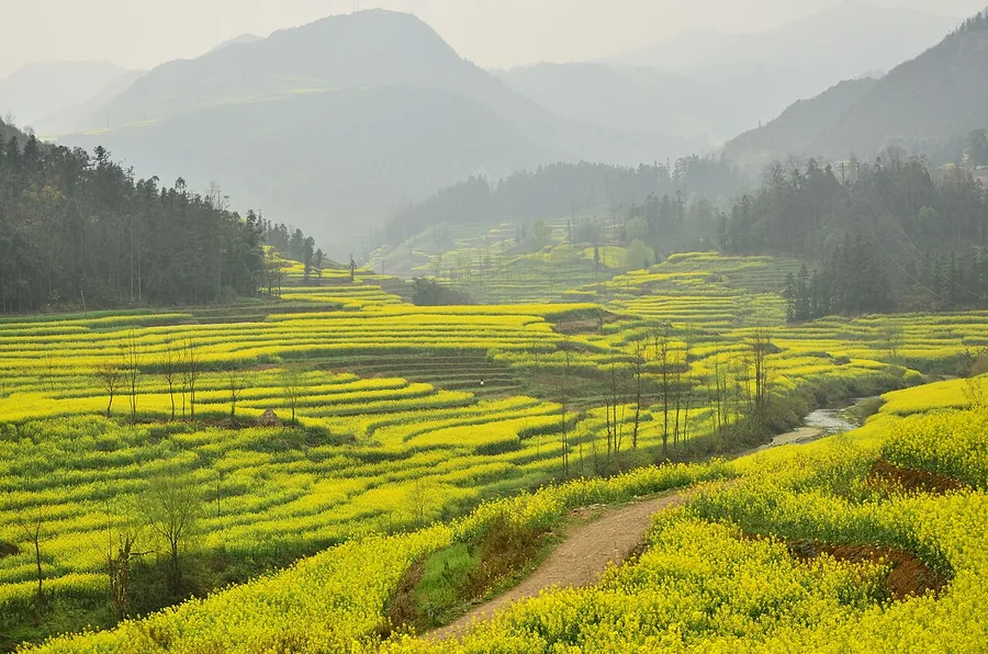
At Jinji Peak Cluster, isolated and grouped hills rise above the farmland; at Niujie’s Luositian, curved fields create a different, bowl-like pattern. Rapeseed flowers turn these settings yellow during the flowering season, but blooming dates vary with weather and farming. Treat the two areas as separate countryside stops from Luoping, and use recognised paths and viewpoints without stepping into the crop.
What to look for
- Jinji Peak Cluster combines limestone hills with surrounding fields.
- Niujie Luositian shows curved field patterns, especially distinct during rapeseed flowering.
Background & history
Luoping County (Chinese: 罗平县; pinyin: Luópíng Xiàn) is located in Qujing City, in eastern Yunnan province, China. It borders Xingyi, Guizhou to the east, Xilin County, Guangxi Zhuang Autonomous Region to the southeast, Shizong County to the southwest, and Luliang County, Qilin District and Fuyuan County, Yunnan to the northwest. The county of Luoping in eastern Yunnan is noted for its springtime scenery, when its fields of canola (also known as rapeseed) plants are in full bloom, surrounding the area's mountains with a blanket of golden flowers. Located near where Yunnan meets Guizhou and Guangxi, Luoping is about 240 kilometers east of Kunming. Not unlike the terraced fields of Yuanyang in southern Yunnan, Luoping's canola fields attract many photographers. The canola flowering lasts until late June. During this high travel season for the county regular buses leave from Kunming's bus stations on an almost hourly basis.
Excerpt from Wikipedia: Luoping County · Wikipedia contributors · CC BY-SA 4.0. Selected introductory sentences; formatting simplified. Background information, not current visitor-service advice.
Location & getting there
Getting to Luoping
For the flower-and-karst landscape, travel from Luoping to the Jinji Peak Cluster visitor area. Niujie Luositian is another named road destination; arrange a separate connection rather than expecting both areas to share one entrance.
Combine your visit
Suggested order for the visit:
-
Jinji Peak Cluster
See the hills rising from the fields.
-
Niujie Luositian
Compare the curved field pattern on a separate road stop.
This is an editorial sequence of named spaces or places. It does not imply a verified walking connection or promise opening, ticket availability or a journey time.

Find Luoping
罗平 · 曲靖
The pin marks the area, not the entrance.
More places nearby
Approximate straight-line distances between map pins, not travel distances.
Jiulong Waterfalls 九龙瀑布群
17 km awayLuoping’s Jiulong Waterfalls descend in a series along the Jiulong River, with separate drops and pools creating a layered valley view. Shenlong Waterfall is the principal named fall, while higher viewpoints help show how the…
View guide →Puzhehei 普者黑
88 km awayPuzhehei is a landscape of connected lakes, limestone hills and villages in Qiubei. Qinglong Hill provides an elevated perspective over the water and surrounding peaks, while the lakeside settlements of Puzhehei and Xianrendong…
View guide →Stone Forest 石林
100 km awayThe Stone Forest turns limestone into a close-packed landscape of pillars, fins and narrow passages. In the Major Stone Forest, the rocks rise around you like walls; the Minor Stone Forest gives more space to see individual…
View guide →Sources & visit information
The sources below support the place-specific description and arrival information. Suggested combinations are editorial planning ideas; confirm current opening, entry arrangements and transport services for your date.
- Luoping County ↗
- Xinhua field report: Luoping rapeseed landscapes ↗
- Yunnan report: Luoping fields and peak clusters ↗
Visitor information adapted and edited from Wikipedia contributors, “Luoping County” · CC BY-SA 4.0. Source revision 1331073518.