

Explore the region
About Wanding Bridge
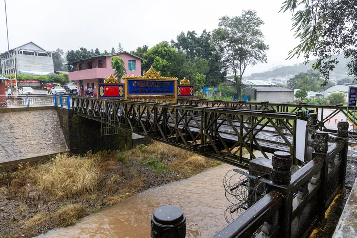
Wanding Bridge (畹町桥) is the old border bridge over the Wanding River (畹町河) at Wanding (畹町镇) in Ruili (瑞丽), Yunnan, linking China with Pangsai (棒赛), also called Jiugu (九谷), in Myanmar. It stands where the Chinese section of the wartime Burma Road (滇缅公路) ended.
Wanding's name means "the sun overhead" in the Dai language. A wooden bridge crossed the river here after a road from Mangshi (芒市) was opened in the 1920s. When the Burma Road was rushed through in 1938, running 1,146 km from Kunming to Lashio (腊戍) in Myanmar, the wooden bridge was replaced by an 8-metre single-arch stone bridge able to carry 10-tonne trucks. Chinese Wikipedia puts the supplies that came into China across it, before Japanese forces took Wanding in May 1942, at more than 500,000 tonnes. From 1939 more than 3,200 volunteer drivers and mechanics from the overseas Chinese communities of Southeast Asia hauled aid over it, and in March 1942 the Chinese Expeditionary Force (中国远征军) crossed it to fight in Burma.
Retreating Japanese troops blew up the stone bridge on 20 January 1945. Chinese and American engineers then put up the Bailey-type steel truss bridge that still stands, working for seven days; Chinese Wikipedia gives it as 21 metres long, 5 metres wide and 9 metres above the water. On 21 January a flag-raising ceremony at Wanding marked the recovery of western Yunnan, and on 28 January the opening of the China–India road (中印公路) was celebrated at the bridgehead.
On 15 December 1956 Premier Zhou Enlai (周恩来) walked across the bridge into China with the Burmese prime minister Ba Swe (吴巴瑞) on the way to a border people's friendship gathering in Mangshi. The bridge was strengthened in 1979. A new 40-metre bridge built by both countries between March 1992 and February 1993 took over the traffic, and the old bridge was kept for visitors. It became a Yunnan provincial protected site in 2012 and was raised to a national key cultural relic protection unit in 2019, in the eighth batch. Forty-seven Expeditionary Force veterans from 14 provinces settled at Tuanjie Village (团结村), not far from the bridge.
What to look for
- The 1945 Bailey-type steel truss bridge, built by Chinese and American engineers in seven days, with steel railings on both sides
- The 1993 border bridge beside it, a 40-metre bridge built by China and Myanmar in 1992-93 to take over from the old one
- Site of the China-Myanmar Border People's Friendship Gathering building (中缅边民联欢大会楼旧址), included in the 2019 national listing
- Site of the building of the first China-Myanmar boundary survey meeting (中缅首次勘界会议楼旧址), listed by Yunnan province in 2012
- Wanding Port (畹町口岸), made a national-level port in 1952, with the bridge an important part of it
- Tuanjie Village (团结村), where 47 veterans of the Chinese Expeditionary Force settled after 1945
Location & getting there
Getting to Wanding Bridge
- Search for 畹町桥 with 德宏傣族景颇族自治州 and 瑞丽市.
Find Wanding Bridge
畹町桥 · 瑞丽市
No reliable map pin yet: search by the Chinese name.
Sources & visit information
Written from the linked sources and fact-checked against them on 2026-09-23. Opening hours, admission and access arrangements are not covered; confirm current visitor information with the site.
Some facts checked against Wikipedia contributors, "畹町桥" · CC BY-SA 4.0.
Image credits & notes (1)
- Wanding Bridge on the China-Myanmar border, Ruili · 中缅国界畹町桥,瑞丽市Photo: 瑞丽江的河水 · CC BY-SA 4.0 · taken 2025-11-03Resized for the web; the photo itself has not been edited. Thumbnails may show a cropped view.
