

Photo adjustments
Full frame retained; proportionally resized and converted to WebP. No retouching or changes to the photographed subject. Card displays may crop the view.
Explore the region
About Baizhangxia
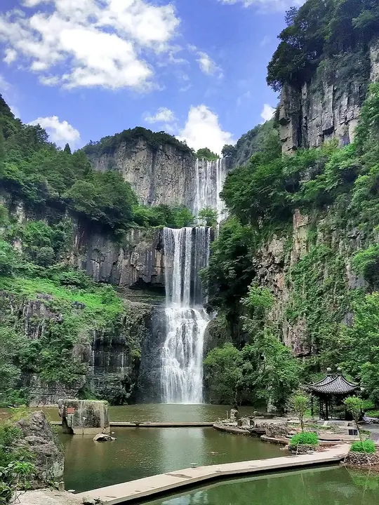
The first is a tall drop, the second combines falling water with an overhanging rock corridor, and the third spreads into a broader, lower cascade. Their different shapes reward following the managed sequence rather than viewing only the highest fall. The route descends substantially, and the return connection matters: confirm the current entrance, exit and scenic shuttle arrangements before entering the valley.
The falls occupy a V-shaped valley in the Donggong Mountains (洞宫山脉), surrounded by high ground rising to about 800 metres. The stream extends for 1,200 metres, with a total descent of 365 metres. The first fall is more than 30 metres wide. Below the second fall lies a pool called Longjing (龙井). Farther upstream, a reservoir was built and is now known as Tianding Lake (天顶湖), linking the waterfall landscape with an artificial body of water above it. The falls and nearby scenic areas were designated a National Key Scenic Area (国家重点风景名胜区) in 2004.
What to look for
- The tall first waterfall contrasts with the broader lower cascade.
- The second stage includes an overhanging rock corridor beside the falling water.
The surrounding area
Southern Zhejiang's distinct urban and commercial life, well beyond a short Hangzhou detour.
Location & getting there
Getting to Baizhangxia
Approach the north visitor centre at Huangzhuang Village in Baizhangji town, Wencheng. Confirm the north-to-south route and return transfer before descending toward the waterfalls.
Combine your visit
A suggested sequence linking the specific features of this visit.
-
First waterfall
Begin with the tall upper drop.
-
Second waterfall
Compare the falling water with the rock corridor from the authorized path.
-
Third waterfall
Finish with the wider lower cascade before the planned exit connection.
This order is editorial. Confirm access and any transfers between stops; it does not establish a walking route, same-day connection or common admission ticket.

Find Baizhangxia
百丈漈 · 温州市
The pin marks the area, not the entrance.
More places nearby
Approximate straight-line distances between map pins, not travel distances.
Yunhe Rice Terraces 云和梯田
56 km awayThe Yunhe terraces step across the mountains around Chongtou, combining rice cultivation with a carefully managed water landscape. Their narrow plots and retaining edges make the work of adapting steep ground visible. Xiayang…
View guide →Guyan Huaxiang 古堰画乡
58 km awayGuyan Huaxiang brings together the Tongji irrigation works and an artists’ riverside settlement. The curved weir diverts water into a canal system, while old camphor trees and Wenchang Pavilion make the channel a cultural…
View guide →Jiangxin Island 江心屿
65 km awayJiangxin Island divides the Ou River in Wenzhou and is marked by its East and West Pagodas. Their long association with navigation gives the river views a historical purpose beyond scenery. Jiangxin Temple occupies the central…
View guide →Sources & visit information
The sources below support the place-specific description and arrival information. Suggested combinations are editorial planning ideas; confirm current opening, entry arrangements and transport services for your date.
Visitor information adapted and edited from Wikipedia contributors, “百丈漈” · CC BY-SA 4.0. Source revision 92583750.
Visitor information adapted and edited from Wikivoyage contributors, listing “Baizhangxia” · CC BY-SA 4.0.
Background paragraphs translated and condensed from Wikipedia contributors, "百丈漈", Chinese Wikipedia · CC BY-SA 4.0. Source revision 92583750.