

Explore the region
About Kanas Scenic Area
Kanas Scenic Area (喀纳斯) covers 10,030 km² of the middle Altai Mountains (阿尔泰山) in northern Burqin County (布尔津县), Altay Prefecture, where Xinjiang borders Kazakhstan and Russia to the north and Mongolia to the east. It includes Kanas Lake (喀纳斯湖), whose Mongolian name means "beautiful and mysterious lake".
The area combines glaciers, snowfields, high mountains, rivers, lakes, forest and grassland, and contains a national nature reserve, a national geopark and two national forest parks. The Kanas Scenic Area Administrative Committee describes it as the only extension of Siberian taiga into China and as the source of the Burqin River (布尔津河), the largest tributary of the Irtysh (额尔齐斯河), China's only river draining to the Arctic Ocean. Below Friendship Peak (友谊峰, 4,374 m) the vegetation runs in belts from alpine cushion plants and meadows down to mountain forest-steppe. A retired staff member of the Chinese Academy of Sciences' Xinjiang Institute of Ecology and Geography, writing on the institute's website, counts more than 500 higher plant species and over 200 bird species in the forest zone.
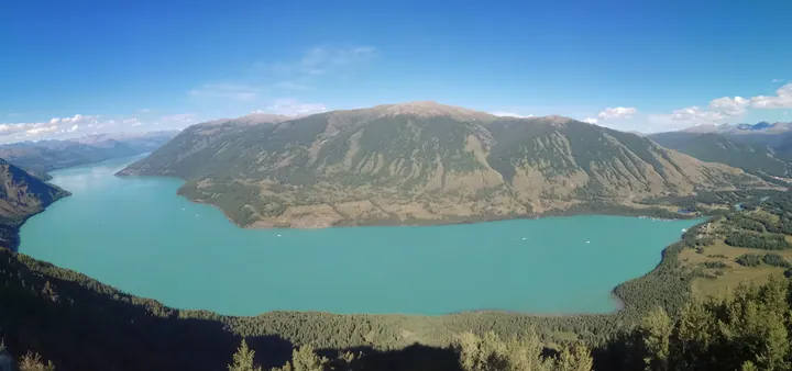
Kanas Lake is a moraine-dammed lake carved by Quaternary glaciers, formed around 200,000 years ago according to the committee, and fed by meltwater from glaciers on Kuitun Peak (奎屯峰) and Friendship Peak plus local rain and snow. It lies at 1,374 m, about 24.5 km long and 1.87 km wide on average, with a mean depth of 120 m; the committee gives a maximum depth of 197 m, Chinese Wikipedia 188.5 m. Local stories tell of a lake monster, a "big red fish" (大红鱼) said to reach 10 m. The ichthyologist Li Sizhong (李思忠), who watched large fish surfacing from the fish-viewing pavilion on the west shore in July 1988, maintained that people were seeing shoals of taimen (哲罗鲑) rather than a single giant fish.
The Kanas River (喀纳斯河) flows out of the lake and runs through a glacial U-shaped valley, where it widens into several named bays. Mudflows and rockfalls have narrowed the channel in places, slowing the water and building islets and shoals. About 2,000 Tuvan people (图瓦人), classed in China as Mongolian, live around the lake; Hemu (禾木), Baihaba (白哈巴) and Kanas village (喀纳斯村) are the committee's three cultural landscape areas.
What to look for
- Wolong Bay (卧龙湾, 1,325 m), named after a dragon-shaped islet; locals call it Kazan Lake, the "pot-bottom lake"
- Moon Bay (月亮湾, 1,326 m), a crescent bend of the Kanas River with foot-shaped grassy islets called the "god's footprints"
- Shenxian Bay (神仙湾, 1,327 m), the widest reach of the Kanas River, often in mist and also known as Pearl Shoal (珍珠滩)
- The Fish-Viewing Platform (观鱼台), 19 m high and more than 660 m above the lake, rebuilt after 2009 on the site of a 1987 pavilion
- Kanas Lake, fed by glaciers of Friendship Peak and Kuitun Peak
- Hemu, Baihaba and Kanas villages, the committee's three cultural landscape areas
Location & getting there
Getting to Kanas Scenic Area
- Search for 喀纳斯 with 阿勒泰地区 and 布尔津县.

Find Kanas Scenic Area
喀纳斯 · 布尔津县
No reliable map pin yet: search by the Chinese name.
Sources & visit information
Written from the linked sources and fact-checked against them on 2026-09-23. Opening hours, admission and access arrangements are not covered; confirm current visitor information with the site.
Some facts checked against Wikipedia contributors, "喀纳斯湖" · CC BY-SA 4.0.
Image credits & notes (1)
- Kanas Lake seen from a viewing platform above, with forested mountains around its turquoise water · 从观景台俯瞰喀纳斯湖,湖水碧绿,四周群山环绕Photo: Newbamboo · CC BY-SA 4.0 · taken 2018-08-06Resized for the web; the photo itself has not been edited. Thumbnails may show a cropped view.
