


Get to know Shitai County
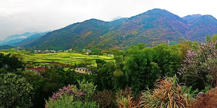
Photo adjustments
Full frame retained; resized proportionally to a maximum dimension of 960 pixels and converted to WebP quality 88. No crop, retouch, generated elements, or subject alteration. Final website rendition: full frame retained, proportionally resized to at most 720 pixels and converted to WebP. No additional retouching or subject alteration. Card displays may crop the view.
- Administrative area
- County · 县
- Part of
- Chizhou
- Chinese name
- 石台县
- Local areas
- County guide
Area & population
- Area in the source
- 1,403.00 km²
- Population · 2019
- 107,553
Source: cited geographic source, as of the dates shown.
Setting and landscape
The county government describes a landscape of low mountains and high hills covering about 82 per cent of the county. Offshoots of the Huangshan range (黄山) fill the south and the southern end of the Jiuhua range (九华山) the north, so the land is high to the north and south and lower to the east and west. Heights fall from the Guniujiang summit to 34 metres in the bed of the Huangpen River (黄湓河) at Dongzhuang village (东庄村). The soils are rich in selenium, with more than 0.2 mg/kg in the soil.
History
Around 245, under the Wu kingdom, a Shidai post (石埭场) was set up here, named after three large rocks in the stream at Diaoyutai (钓鱼台) on the upper Qiupu that blocked it like a weir (埭, dai). Shidai County was created in 536 and re-established in 766. It was abolished in 1959; on 19 July 1965 a new county was carved from Taiping and Guichi, and the name was changed to Shitai because the character "埭" (dai) was rare and sounds like "台" (tai) in the local speech. It has belonged to Chizhou city since June 2000.
What to see
Guniujiang, shared with Qimen County (祁门县), is a national nature reserve established in 1982 and forms the main westward extension of the Huangshan range. The Guniujiang scenic area, with the Longmen Pool (龙门潭), is working toward a national 5A rating; a 1.6-kilometre stepped trail climbs its gorge, and in Yanjia village (严家古村) 11 century-old houses have been restored.
Li Bai (李白) visited Qiupu five times and wrote his "Seventeen Songs of Qiupu" (秋浦歌十七首) there. In 2026 the Anhui Department of Culture and Tourism included the river in its "Poetry through a Thousand Years" (诗行千载) heritage trail. Penglai Xiandong (蓬莱仙洞), below Shanshan hill (杉山) in Gongxi township (贡溪乡), is a karst cave more than 3,000 metres long, with an underground river, stalagmites and flowstone curtains, as CCTV reported.
Food and local products
The county grows much tea and is an important tea base for Anhui; Shitai selenium-rich tea (石台富硒茶) is a Chinese geographical-indication product.
Highlights
- Guniujiang 牯牛降: National nature reserve on the Qimen border; main peak 1,728 m.
- Qiupu River 秋浦河: River of Li Bai's Seventeen Songs of Qiupu, on Anhui's 2026 poetry heritage trail.
- Penglai Xiandong 蓬莱仙洞: Karst cave over 3,000 m long with an underground river, in Gongxi township.
- Shitai selenium-rich tea 石台富硒茶: Chinese geographical-indication product.
Sources for this guide
自然地理-石台县人民政府 · Shitai County People's Government
历史沿革-石台县人民政府 · Shitai County People's Government
十三年“磨”一剑!牯牛降,向着国家“5A”全力冲刺!-石台县人民政府 · Shitai County People's Government (Shitai County Media Centre)
省级文旅新名片!秋浦河成功入选-石台县人民政府 · Shitai County People's Government
石台县 - 维基百科,自由的百科全书 · Chinese Wikipedia · CC BY-SA 4.0
牯牛降 - 维基百科,自由的百科全书 · Chinese Wikipedia · CC BY-SA 4.0
蓬莱仙洞:曲径通幽 宛若一座富丽堂皇的地下宫殿 · CCTV (cctv.com)
Original English written from the listed sources and checked sentence by sentence against quoted extracts by a separate reviewer. Updated 2026-09-25.
Explore Shitai County
Core places to explore, with English and Chinese names.
Places to explore around Shitai County
 AI illustration · AI 示意图(仅供参考,非该地点实拍)
Guniujiang Longmen Scenic Area牯牛降龙门景区
Longmen is the northern-foot section of Guniujiang in Shitai County, combining clear-water gorge scenery with Yanjia Village.
Read the place guide → The Qiupu River near its confluence with the Yangtze in Guichi District, Chizhou, the same river that flows through Shitai County · 秋浦河入江口,池州市贵池区 Source-recorded photograph date: 2021-10-02.
Qiupu River秋浦河
Yangtze tributary flowing from Qimen through Shitai to Chizhou, the river of Li Bai's Seventeen Songs of Qiupu and of its mandarin fish.
Read the place guide →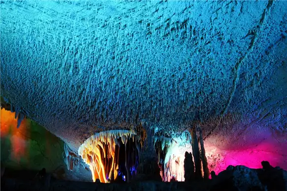 Penglai Fairy Cave · 蓬莱仙洞
Penglai Fairy Cave蓬莱仙洞
Penglai Xiandong in Du Village, Shitai County, is a cave system of upper, middle and lower chambers above an underground river.
Read the place guide →Plan your visit
Getting there
Shitai County is about 50 km in a straight line from central Chizhou. Search for 石台县 in a map app to find stations and your accommodation.
Where to stay →Build your route
Guniujiang Longmen Scenic Area and Qiupu River are both listed here. The linked place guides have entrance and visit details.
Continue with Chizhou →More in Chizhou
Sources & geographic information
Administrative names and parent areas: Official geographic directory · Reference date 2026-09-06.
Some facts checked against 石台县 — Wikipedia contributors, CC BY-SA 4.0.
Some facts checked against 牯牛降 — Wikipedia contributors, CC BY-SA 4.0.
Photo: Qiupu River · William Ng · CC BY-SA 4.0. Full frame retained; proportionally resized and converted to WebP. No retouching or changes to the photographed subject. Card displays may crop the view.

Photo: Penglai Fairy Cave · Source photographer · License not provided. EXIF orientation normalized; resized without changing aspect ratio; converted to WebP. No subject edits.
Map data © OpenStreetMap contributors. Pins mark approximate centres, not entrances or boundaries.