

Photo adjustments
EXIF orientation normalized; resized without changing aspect ratio; converted to WebP. No subject edits.
Explore the region
About Tangkou
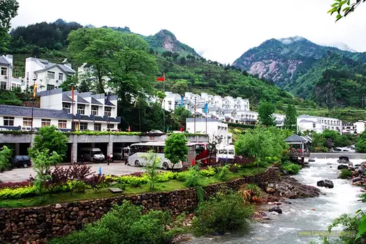
The town serves the Yuping and Yungu approaches, which lead to different walking routes among the granite peaks and pines. Nearby Emerald Valley at Shancha offers a lower-level landscape of rock pools. Keep the mountain and valley outings separate when planning transport: Tangkou is the foothill service town, while Tunxi is Huangshan City’s more distant urban centre.
Tangkou lies 2.5 kilometers from the southern gate of Huangshan Scenic Area and is a town-level unit under Huangshan District. It originally belonged to She County and was transferred to Huangshan District at the end of 1983. In earlier times the area lay deep in the mountains and saw few visitors. During the 1930s a road connecting to Yanshi town opened, along with a mountain road from Tangkou to Huangshan Maopeng, and a market for mountain produce began to develop; in the 1980s, as tourism on Huangshan grew, Tangkou developed rapidly.
What to look for
- The southern mountain approaches to Huangshan’s granite-and-pine scenery.
- Emerald Valley’s coloured rock pools near Shancha village.
Location & getting there
Getting to Tangkou
Travel to the Huangshan south-gate transfer centre in Tangkou. Select the official scenic shuttle serving your booked Yuping or Yungu approach. Huangshan North station has a linked tourist passenger centre for onward mountain connections.
Combine your visit
A suggested sequence linking the specific features of this visit.
-
Yuping mountain area
Plan a mountain visit around the granite scenery and Welcoming-Guest Pine.
-
Emerald Valley
Use a separate outing for the lower valley’s rock pools near Shancha.
This order is editorial. Confirm access and any transfers between stops; it does not establish a walking route, same-day connection or common admission ticket.
Find Tangkou
汤口 · 黄山市
The pin marks the area, not the entrance.
More places nearby
Approximate straight-line distances between map pins, not travel distances.
Tiandu Peak · Yuping visitor-area reference 天都峰·玉屏片区示意点
5 km awayTiandu Peak rises sharply above Huangshan’s southern mountain routes, with narrow rock passages and the exposed Carp’s Backbone ridge distinguishing it from the broader summit viewpoints. The approach is a demanding stair climb…
View guide →Mount Huangshan 黄山
5 km awayHuangshan’s granite ridges and pines form a landscape made familiar by Chinese painting. Around Yuping, Welcoming-Guest Pine gives the rock-and-tree relationship a particular focus; Bright Summit opens a broader view across the…
View guide →Chengkan 呈坎
19 km awayChengkan’s village lanes lead between houses and communal buildings of the Luo clan. The Luo Dongshu ancestral hall is the main architectural focus: its courtyards lead to Baolun Pavilion, where painted timber framing gives the…
View guide →Sources & visit information
The sources below support the place-specific description and arrival information. Suggested combinations are editorial planning ideas; confirm current opening, entry arrangements and transport services for your date.
- 汤口镇 ↗
- www.hslyjt.com ↗
- Huangshan ↗
- www.csair.com ↗
- Chinese Wikipedia: 汤口镇 (revision 78041446, 2023-07-11) ↗
Visitor information adapted and edited from Wikivoyage contributors, “Huangshan” · CC BY-SA 4.0.
Visitor information adapted and edited from Wikipedia contributors, “汤口镇” · CC BY-SA 4.0. Source revision 78041446.
Background paragraphs translated and condensed from Wikipedia contributors, "汤口镇", Chinese Wikipedia · CC BY-SA 4.0. Source revision 78041446.