

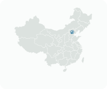
Get to know Fengtai District

Photo adjustments
Full frame retained; proportionally resized and converted to WebP. No retouching or changes to the photographed subject. Card displays may crop the view.
- Administrative area
- District · 市辖区
- Part of
- Beijing
- Chinese name
- 丰台区
- Local areas
- District guide
Area & population
- Area in the source
- 306.00 km²
- Population · 2020
- 2,019,764
Source: cited geographic source, as of the dates shown.
Setting and landscape
The land steps down from north-west to south-east. The Yongding, known in the past by names including the Lugou River (卢沟河) and the Hun River (浑河), runs north to south through the district for about 11.3 kilometres, entering from Shijingshan (石景山区) and leaving for Daxing (大兴区). The district government lists large green spaces such as the Beijing Garden Expo Park (北京园博园), Qianling Mountain (千灵山) and the Nanyuan Forest Wetland Park (南苑森林湿地公园).
History
Under the Western Han, Yinxiang County (阴乡县) had its seat in the area of today's Baotai (葆台). The district government says that the Jin capital Zhongdu (金中都) opened the history of Beijing as a capital, and Chinese Wikipedia says the name Fengtai is thought to come from a sacrificial platform outside Zhongdu's Fengyi Gate (丰宜门). The modern district was set up in 1952, when Wanping County (宛平县) was abolished.
Changxindian (长辛店) saw the Beijing–Hankou railway workers' strike, which the district government calls the largest and most influential of the first high tide of the Chinese labour movement. The Marco Polo Bridge (卢沟桥) and Wanping Fortress (宛平城) are where the nationwide War of Resistance against Japan broke out in 1937.
What to see
The Marco Polo Bridge crosses the Yongding about 15 kilometres south-west of central Beijing. It was begun in 1189 and completed in 1192 under the Jin, and rebuilt by the Kangxi Emperor in 1698. The granite bridge is 266.5 metres long on 11 arches, and its parapets carry hundreds of stone lions, most from the Ming and Qing. A stele with the Qianlong Emperor's calligraphy reads "Morning moon over Lugou" (卢沟晓月). At its eastern end, the 17th-century Wanping Fortress contains the national museum of the war against Japan (中国人民抗日战争纪念馆). Chinese Wikipedia also lists the Dabaotai Han Tomb (大葆台汉墓) and Beijing World Park (北京世界公园) among the district's sights.
Getting oriented
Chinese Wikipedia places three of Beijing's principal rail stations in Fengtai: Beijing West, Beijing South and Beijing Fengtai. The district government says its three high-speed rail stations carry more than three quarters of the city's rail passengers, and that seven expressways start from the district.
Highlights
- Marco Polo Bridge 卢沟桥: Jin-dynasty stone bridge of 1189–1192 over the Yongding, lined with carved lions.
- Wanping Fortress 宛平城: 17th-century fortress at the bridge's eastern end, housing the war-of-resistance museum.
- Beijing Garden Expo Park 北京园博园: One of the large green spaces named by the district government.
- Changxindian 长辛店: Scene of the Beijing–Hankou railway workers' strike.
Sources for this guide
丰台概况-北京市丰台区人民政府网站 · Fengtai District People's Government, Beijing
丰台概况-北京市丰台区人民政府网站 (地理环境) · Fengtai District People's Government, Beijing
丰台概况-北京市丰台区人民政府网站 (历史沿革) · Fengtai District People's Government, Beijing
丰台区 - 维基百科,自由的百科全书 · Wikipedia · CC BY-SA 4.0
Marco Polo Bridge - Wikipedia · Wikipedia · CC BY-SA 4.0
Original English written from the listed sources and checked sentence by sentence against quoted extracts by a separate reviewer. Updated 2026-09-25.
Explore Fengtai District
Core places to explore, with English and Chinese names.
Places to explore around Fengtai District
 Marco Polo Bridge · 卢沟桥. Photo: 2014-07-12.
Marco Polo Bridge卢沟桥
Marco Polo Bridge, known locally as Lugou Bridge, crosses the Yongding River beside Wanping Fortress in southwestern Beijing. Its sequence of stone arches and balustrades belongs to a long history of bridge building, while the…
Read the place guide → The entrance facade of the Museum of the War of Chinese People's Resistance Against Japanese Aggression in Beijing.
Museum of the War of Chinese People's Resistance Against Japanese Aggression中国人民抗日战争纪念馆
This war-history museum stands inside Wanping Fortress beside the Marco Polo Bridge, placing its exhibitions close to the July 1937 incident that marked the start of full-scale war between China and Japan. The gate-like museum…
Read the place guide → The Kunming Garden section of Beijing Garden Expo Park; 1 January 2015.
Beijing Garden Expo Park北京园博园
Beijing Garden Expo Park preserves the garden exhibition landscape created beside the Yongding River in Fengtai. Its themed gardens allow comparisons among imperial, Jiangnan, and Lingnan design traditions, while the broader…
Read the place guide → Miniature British landmark buildings inside Beijing World Park.
Beijing World Park北京世界公园
Beijing World Park is a miniature-landmark theme park in Fengtai, presenting replicas of well-known buildings and monuments from several continents. Its entrance combines European-inspired architectural forms, followed by…
Read the place guide → The Dabaotai Western Han tomb display photographed in March 2011, before the museum's 2025 rebuilding.
Dabaotai Western Han Tombs Museum大葆台西汉墓博物馆
The Dabaotai site museum is built over Western Han tombs associated with Liu Jian, Prince of Guangyang, and his consort. The tomb structures and inner and outer coffins provide an unusually direct way to study elite Han burial…
Read the place guide → A wide view along the stone deck of Lugou Bridge, its balustrades lined with carved stone lion posts and iron railings, with visitors walking and cycling; the gate tower of Wanping town stands at the far end beyond green trees under a blue sky with white cumulus clouds.
Lugou Bridge and Wanping Town卢沟桥与宛平城
Lugou Bridge, also known internationally as the Marco Polo Bridge, is a historic stone crossing in southwestern Beijing.
Read the place guide →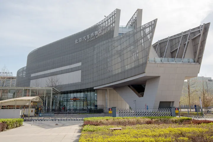 Exterior of the Beijing Auto Museum in Fengtai District, Beijing · 北京丰台区北京汽车博物馆外观 Source-recorded photograph date: 3 April 2016, Beijing, China.
Beijing Auto Museum北京汽车博物馆
Beijing Auto Museum (北京汽车博物馆) is an automobile museum in Fengtai District, on the west section of the South Fourth Ring Road.
Read the place guide →Plan your visit
Getting there
Fengtai District is about 10 km in a straight line from central Beijing. Search for 丰台区 in a map app to find stations and your accommodation.
Where to stay →Build your route
Marco Polo Bridge and Museum of the War of Chinese People's Resistance Against Japanese Aggression are about 1 km apart in a straight line. The linked place guides have entrance and visit details.
Continue with Beijing →More in Beijing
Sources & geographic information
Administrative names and parent areas: Official geographic directory · Reference date 2026-09-06.
Some facts checked against 丰台区 — Wikipedia contributors, CC BY-SA 4.0.
Some facts checked against Marco Polo Bridge — Wikipedia contributors, CC BY-SA 4.0.
Photo: Marco Polo Bridge · Alanba42 · CC BY-SA 4.0. Converted to WebP and resized without changing the subject or cropping the source frame.

Photo: Museum of the War of Chinese People's Resistance Against Japanese Aggression · H2v5o68z · CC0. Proportionally resized and converted to WebP without cropping, retouching or changing the photographed subject.

Photo: Beijing Garden Expo Park · HappyNikita · CC BY-SA 4.0. Proportionally resized and converted to WebP without cropping, retouching or changing the photographed subject.

Photo: Beijing World Park · Techyan · CC BY-SA 4.0. Proportionally resized and converted to WebP without cropping, retouching or changing the photographed subject.

Photo: Dabaotai Western Han Tombs Museum · Mlogic · CC BY-SA 3.0. Proportionally resized and converted to WebP without cropping, retouching or changing the photographed subject.

Photo: Lugou Bridge and Wanping Town · 三猎 · CC BY-SA 4.0. Full frame retained; proportionally resized and converted to WebP. No retouching or changes to the photographed subject. Card displays may crop the view.

Photo: Beijing Auto Museum · Morio · CC BY-SA 4.0. Full frame retained; proportionally resized and converted to WebP. No retouching or changes to the photographed subject. Card displays may crop the view.
_2016_April.jpg)
Map data © OpenStreetMap contributors. Pins mark approximate centres, not entrances or boundaries.