


Get to know Qiuxian
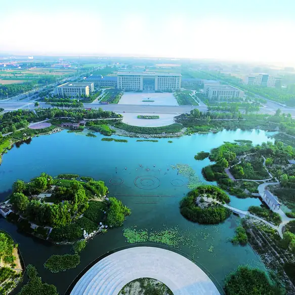
Photo adjustments
EXIF orientation normalized; resized without changing aspect ratio; converted to WebP. No subject edits.
- Administrative area
- County · 县
- Part of
- Handan
- Chinese name
- 邱县
- Local areas
- County guide
Setting and landscape
Heights stay between 32.8 and 40.8 metres across the whole county, and the ground tilts from southeast to northwest. Fourteen rivers and canals drain into the Heilonggang (黑龙港) basin: the Laosha River (老沙河) in the east, the Heyi Canal (合义渠) in the middle and the Old Zhang River (老漳河) in the west. The county seat is Xinmatou (新马头镇). After the Han, the Hui are the largest group, mostly in Chencun Hui Ethnic Township (陈村回族乡) and Qiucheng (邱城镇).
History
In 67 BC the Western Han created the Pingen (平恩) marquisate west of present-day Qiucheng, and in 586 Pingen County moved its seat to Qiucheng itself. Qiu County was set up in 1289 under the Yuan and belonged to Shandong through the Ming and Qing. In 1726 its name was rewritten with a different character for qiu (邱 instead of 丘) to avoid the personal name of Confucius. Matou, called Baijiatan (白家滩) under the Song, was a river port; the county describes it as the last Northern Song stronghold against the Jin, held by the imperial clansman Zhao Shiwu (赵士珸) until the fourth month of 1128. The county joined Hebei in 1949, was merged into Quzhou (曲周) in 1958 and restored in 1962.
What to see
The county highlights the Juqiao site (巨桥遗址), an ancient town that appeared north of Guchengying (古城营) under the last Shang king, and the site of the Battle of Xiangchenggu (香城固战役旧址), which Liu Bocheng (刘伯承) praised as a model ambush on the plain. Qiuxian is named by the Ministry of Culture and Tourism as a home of folk art for its cartoons: the Frog Cartoon Group (青蛙漫画组), founded by the farmer cartoonists Chen Yuli (陈玉理) and Li Qing'ai (李青艾), has produced more than 60,000 cartoons. A local puppet act, the Two Ghosts Wrestling (二鬼扳), has one performer inside a cloth bag working two half-figures and voicing both.
Food and local products
Fish is expected at every banquet here. Liu Si crispy fish (刘四酥鱼) from Qiucheng is simmered for three to six hours in rice-rinsing water with onion, ginger, garlic, vinegar and sugar. Chencun beef and mutton relish (陈村牛羊肉卤), a Hui creation said to be over 500 years old, is fried from mutton fat, homemade bean paste and fresh mutton and keeps for two or three months in summer. Sesame-oil pancake rolls wrap chopped beef, pork knuckle or donkey meat, and Qiucheng's West and South streets make handmade hanging noodles from local wheat.
Highlights
- Juqiao site 巨桥遗址: Settlement site north of Guchengying dated by the county to the last Shang king; digitally recorded in the county's 2025 heritage survey.
- Battle of Xiangchenggu site 香城固战役旧址: Battlefield of an ambush Liu Bocheng praised as a model for fighting on the plain.
- Frog Cartoon Group 青蛙漫画组: Farmer cartoonists' group founded by Chen Yuli and Li Qing'ai, with more than 60,000 cartoons.
- Chencun beef and mutton relish 陈村牛羊肉卤: Hui relish of mutton fat, bean paste and mutton, said to be over 500 years old.
- Liu Si crispy fish 刘四酥鱼: Qiucheng fish simmered three to six hours in rice-rinsing water.
Sources for this guide
走进邱县-邱县人民政府 · Qiu County People's Government, Handan
Original English written from the listed sources and checked sentence by sentence against quoted extracts by a separate reviewer. Updated 2026-09-24.
Explore Qiuxian
Core places to explore, with English and Chinese names.
Plan your visit
Getting there
Qiuxian is about 65 km in a straight line from central Handan. Search for 邱县 in a map app to find stations and your accommodation.
Where to stay →More in Handan
Sources & geographic information
Administrative names and parent areas: Official geographic directory · Reference date 2026-09-06.
Map data © OpenStreetMap contributors. Pins mark approximate centres, not entrances or boundaries.