

Get to know Guia

Photo adjustments
EXIF orientation normalized; resized without changing aspect ratio; converted to WebP. No subject edits.
- Administrative area
- Statistical area · 統計分區
- Part of
- Macau
- Chinese name
- 東望洋區(松山區)
- Local areas
- Statistical area guide
Setting and landscape
The hill was once known as Qinshan (琴山), 'zither hill', for its shape, and was bare ground with the sea on its east side. The Portuguese administration planted it with pines in the 19th century, which gave it the popular name Songshan (松山), 'pine hill'. Its Chinese name, Dongwangyang, pairs it with Penha Hill (西望洋山), while the Portuguese name comes from the image of Our Lady of Guia in the hilltop chapel. In the 1920s the land at its eastern foot was reclaimed to create the Outer Harbour new district (新口岸).
The Macau Grand Prix track, known as the Guia Circuit (東望洋賽道), passes along the hill, and the Guia Tunnel (松山隧道) runs beneath it.
History
Guia Fortress was built between 1622 and 1638 and, with Mount Fortress, helped repel the attempted Dutch invasion of 1622. Guia Chapel inside it dates from around 1622 and was founded by Clarist nuns; frescoes combining Western and Chinese themes came to light during conservation work in 1998. Guia Lighthouse, from 1865, was the first modern lighthouse on the Chinese coast, and Macau takes its coordinates from its position. The three structures are part of the Historic Centre of Macao.
What to see
The fortress has a trapezoidal plan of about 800 square metres. The lighthouse is an 18.3-metre tower, 7 metres across at the base, with a spiral stair inside leading up to the light. The chapel's nave measures 16 by 4.7 metres, and its white front has a yellow pediment on pilasters.
The hilltop became Guia Hill Municipal Park (松山市政公園) in 1997, covering about 143,000 square metres. Within the hill run four groups of military tunnels built in 1931 under Second Lieutenant Cunha, 47 to 456 metres long, which once stored generators, coastal guns and ammunition; Group A (47 metres, under the fortress) opened to the public as a display gallery in 2003, and Group B (207 metres) opened in 2013. A cable car opened on 1 October 1997 links the park with Flora Garden (二龍喉公園) below.
Highlights
- Guia Fortress 東望洋炮台: Built 1622 to 1638, with a trapezoidal plan of about 800 square metres.
- Guia Chapel 聖母雪地殿教堂: Founded around 1622 by Clarist nuns; frescoes with Western and Chinese themes were uncovered in 1998.
- Guia Lighthouse 東望洋燈塔: An 18.3-metre tower of 1865, the first modern lighthouse on the Chinese coast; Macau's coordinates are taken from it.
- Guia Hill military tunnels 松山軍用隧道: Four tunnel groups built in 1931; Groups A and B opened to the public in 2003 and 2013.
- Guia Hill Municipal Park 松山市政公園: About 143,000 square metres on the hilltop, created in 1997, with a cable car down to Flora Garden.
Sources for this guide
DSEC statistical zones (CensusGIS layer Zona_Unidade_Zona_2019Q4) · Statistics and Census Service (DSEC), Macao SAR Government
Guia Fortress, Chapel of Our Lady of the Snows and Lighthouse · Cultural Affairs Bureau, Macao SAR Government (Macao World Heritage)
东望洋山 · Chinese Wikipedia · CC BY-SA 4.0
松山市政公园 · Chinese Wikipedia · CC BY-SA 4.0
Original English written from the listed sources and checked sentence by sentence against quoted extracts by a separate reviewer. Updated 2026-09-23.
Find Guia
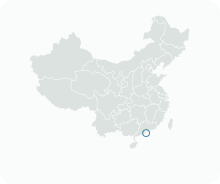
A reliable area-level map point is not available in the current sources.
Plan your visit
Getting there
Search for 東望洋區(松山區) in a map app to find stations and your accommodation.
Where to stay →More in Macau
Sources & geographic information
Administrative names and parent areas: Official geographic directory · Reference date 2026-09-06.
DSEC statistical-zone directory
MGTO: Guia Fortress, Chapel and Lighthouse
MGTO: Guia Hill Pedestrian Tunnel and Walking System
Some facts checked against 东望洋山 — Wikipedia contributors, CC BY-SA 4.0.
Some facts checked against 松山市政公园 — Wikipedia contributors, CC BY-SA 4.0.
Map data © OpenStreetMap contributors. Pins mark approximate centres, not entrances or boundaries.