

Photo adjustments
Proportionally resized and converted to WebP without cropping, retouching or changing the photographed subject.
Explore the region
About Pingtan Island
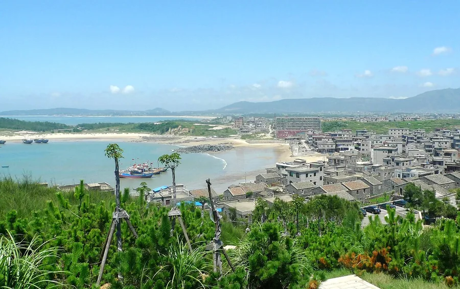
Beigang’s grey stone houses climb above the coast beneath Junshan, with tiled roofs and small lanes facing the sea. Tannan Bay offers a different landscape: a broad pale beach backed by coastal vegetation.
These places occupy different parts of a large island. Choose a village and a stretch of coast for a focused visit; an island-wide circuit needs road transport between its separate bays.
In 1731 (the ninth year of the Qing Yongzheng era), a county lieutenant's office was established on the island, and later county government offices were based there, making it the county's political, economic, cultural and educational centre. The island came under Communist administration in September 1949. The Pingtan Strait Bridge (平潭海峡大桥) to the mainland, 4,976 metres long including a 3,510-metre bridge section with a 17-metre-wide deck, was completed on 30 November 2010 and opened to traffic on 25 December 2010.
The island is about 29 kilometres from north to south and 19 kilometres from east to west, with a coastline of 408 kilometres and a sea area of 6,064 square kilometres; it is known as the 'county of a thousand reefs' (千礁岛县). It is separated from Fuqing on the mainland by the Haitan Strait, and lies about 140 kilometres from Hsinchu in Taiwan, the narrowest point of the Taiwan Strait. A seasonal 'blue tears' phenomenon, a glow produced by blooms of the plankton Vargula hilgendorfii in turbulent water, occurs mainly between April and August.
Haitan is Fuzhou's only national key scenic area, the Haitan National Key Scenic Area (海坛国家重点风景名胜区), covering 71 square kilometres. In 2001 the site was added to the UNESCO World Heritage Tentative List under 'Haitan Scenic Spots,' in the mixed cultural and natural category.
What to look for
- Beigang’s granite houses, tiled roofs and hillside village lanes.
- Tannan Bay’s broad sandy shoreline and coastal outlook.
Background & history
Pingtan Island or Haitan Island is an island of Fuzhou off the east coast of mainland Asia in Pingtan County, Fujian Province, China, south of the complex estuary of the Min River. It is the largest island in Fujian and the fifth-largest island administered by the People's Republic of China.
Excerpt from Wikipedia: Pingtan Island · Wikipedia contributors · CC BY-SA 4.0. Selected introductory sentences; formatting simplified. Background information, not current visitor-service advice.
The surrounding area
The provincial capital offers historic residences and a specific broth-and-snack food culture.
Location & getting there
Getting to Pingtan Island
Pingtan Station on the Fuzhou–Pingtan railway is on the main island. Arrange a road transfer from the station to Beigang village or your chosen bay; the railway stop is not beside either attraction.
Combine your visit
A suggested sequence linking the specific features of this visit.
-
Beigang village
See how the island’s granite is used in the coastal houses.
-
Tannan Bay
Continue by road to a sandy bay for a contrasting coastal landscape.
This order is editorial. Confirm access and any transfers between stops; it does not establish a walking route, same-day connection or common admission ticket.

Find Pingtan Island
平潭岛 · 福州市
The pin marks the area, not the entrance.
More places nearby
Approximate straight-line distances between map pins, not travel distances.
Fuzhou Changle International Airport 福州长乐国际机场
45 km awayFuzhou’s airport lies near the coast at Changle, separate from the old city around the Min River. The Binhai Express links its Airport station with central Fuzhou and the main railway station, making the rail-to-terminal…
View guide →Luoxing Pagoda 罗星塔
58 km awayLuoxing Pagoda stands on Luoxing Hill by the north bank of the Min River in Mawei, Fuzhou. The present stone pagoda is a Ming-period structure.
View guide →Mount Gu (Fujian) 鼓山
69 km awayMount Gu rises in eastern Fuzhou with the Min River to the south and Guling to the north. Yongquan Temple forms a major cultural focus on its slopes.
View guide →Sources & visit information
The sources below support the place-specific description and arrival information. Suggested combinations are editorial planning ideas; confirm current opening, entry arrangements and transport services for your date.
- en.wikipedia.org ↗
- zrzyt.fujian.gov.cn ↗
- hyyyj.fujian.gov.cn ↗
- 海坛岛 ↗
- Chinese Wikipedia: 海坛岛 (revision 93683706, 2026-07-28) ↗
- English Wikipedia: Pingtan Island (revision 1364191517, 2026-07-15) ↗
Visitor information adapted and edited from Wikipedia contributors, “海坛岛” · CC BY-SA 4.0. Source revision 93683706.
Background paragraphs translated and condensed from Wikipedia contributors, "海坛岛", Chinese Wikipedia · CC BY-SA 4.0. Source revision 93683706.
Background paragraphs condensed from Wikipedia contributors, "Pingtan Island", English Wikipedia · CC BY-SA 4.0. Source revision 1364191517.