

Explore the region
About Ganjia Secret Land Visitor Area
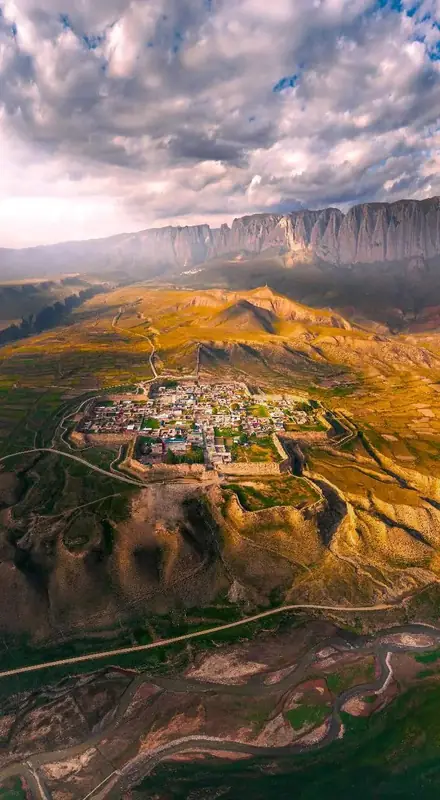
The county government's page places the area in Ganja town, half an hour's drive from the Xiahe county town, at the north-eastern edge of the Tibetan plateau where the Loess plateau and the Gannan grasslands meet, and says it still preserves unworked plateau landforms. Its Ganja grassland lies at an average elevation above 3,200 m, with a million mu of natural pasture running across the hills. The page calls 15 km of continuous Baishiya cliff the area's defining sight: grey-white rock walls that it describes as lying across the grassland like a huge jade screen, steep and deeply folded, with clouds spreading over the summits. Below the cliff it records caves and an underground stream, and the Baishiya temple built against the hillside among the trees, where it says the area's culture and its landscape meet.
On high ground above the river valley the page places an octagonal ancient city that it says has stood for a thousand years, with an octagonal hollow rampart it describes as keeping something of the Tang-Tubo road and rammed-earth walls standing in the grass; a footpath runs along the city wall, and the page says every piece of rammed earth there bears the marks of time. The Gannan prefecture government's page records that the Baishiya cave of the Ganja Mirage scenic area yielded the Xiahe “Denisovan” fossil, which it dates to 200,000 years ago, and describes the same octagonal city as having stood for a thousand years as a witness to the area's history.
The county page records that Xiahe county has taken an ecology-first, light-touch approach to the area, refusing heavy commercial construction, and has developed lightweight tourism projects, among them self-driving routes, mountain walking and folk-culture experiences, and has improved visitor facilities including viewing paths and an ecological car park, linking the grassland, the cliffs and the ancient city into a single touring circuit. It adds that the county has worked with surrounding herders on Tibetan-family guesthouses and pastoral tourism, using local butter, yak milk and barley produce to create spending opportunities for visitors. The prefecture government's page records that the Ganja scenic area is working towards national 4A-grade tourist attraction status.
What to look for
- The 15 km of continuous Baishiya cliff, which the county page calls the area's defining sight, with the grey-white rock walls it describes as lying across the grassland like a huge jade screen
- The caves and underground stream below the cliff, in the Baishiya cave of which the prefecture page places the Xiahe “Denisovan” fossil
- The Baishiya temple, built against the hillside among the trees
- The octagonal ancient city on its high ground above the river valley, with the octagonal hollow rampart and the rammed-earth walls the page describes
- The footpath running along the city wall, where the page says the rammed earth bears the marks of time
Location & getting there
Getting to Ganjia Secret Land Visitor Area
Use an authorised visitor route. Cave sections, geological sites and access roads can close independently, so confirm the area that your ticket covers.
- Search for 甘加秘境开放游览区 with 甘南藏族自治州 and 夏河县.

Find Ganjia Secret Land Visitor Area
甘加秘境开放游览区 · 夏河县
No reliable map pin yet: search by the Chinese name.
Sources & visit information
The linked sources support the identity and background described in this introduction. Opening hours, admission, activity availability and exact arrival arrangements have not been comprehensively checked. Confirm current visitor information with the venue; the original catalogue locality and editorial review flag are retained.
Image credits & notes (1)
- Ganjia Secret Land Visitor Area · 甘加秘境开放游览区Photo: xiahe.gov.cnResized for the web; the photo itself has not been edited.