


Get to know Huan County
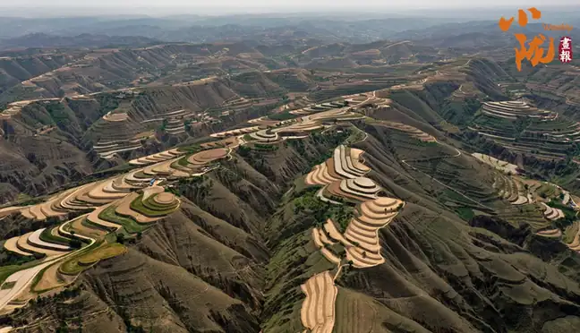
Photo adjustments
EXIF orientation normalized; resized without changing aspect ratio; converted to WebP. No subject edits.
- Administrative area
- County · 县
- Part of
- Qingyang
- Chinese name
- 环县
- Local areas
- County guide
Area & population
- Area in the source
- 9,236.00 km²
- Population · 2019
- 316,703
- Administrative seat
- Huancheng
Source: cited geographic source, as of the dates shown.
Setting and landscape
More than 90 per cent of the county is loess, cut into ridges, gullies and small remnant tablelands, with the Huan River (环江) valley through the middle. The land falls from north-west to south-east, from 2,089 m on Mount Mada (马大山) at Maojing (毛井) to 1,136 m at Quzi (曲子). The Huan River rises at a spring in Tianshui (甜水) and runs 140 km through the county, rising and falling sharply in summer and autumn floods. About 300 mm of rain falls a year, mostly from July to September, and desert land makes up 58 per cent of the county.
History
The Western Han had a Fangqu County (方渠县) based at today's Liuqi village (刘旗村) in Quzi, and in 707 the Tang placed a new Fangqu County at today's Huancheng (环城). In 952 the Later Zhou renamed Wei Prefecture (威州), created in 939, as Huan Prefecture (环州) to avoid the personal name of its founder, Guo Wei (郭威), and this was the first use of the name Huan; in 1369 the Ming reduced it to a county.
In June 1936 the Red Army's Western Field Army took the county, and from July 1936 to 1937 the Shaanxi–Gansu–Ningxia provincial Party committee and Soviet government were based at Helianwan (河连湾) and Quzi.
What to see
The Shanchengbao Battle Memorial (山城堡战役纪念馆), first built in 2009 north of Shancheng (山城乡) on national road G211, 45 km from the county town, marks the battle of November 1936 in which troops under Peng Dehuai (彭德怀) defeated those of Hu Zongnan (胡宗南); the county calls it the last battle of the Long March. The former provincial government site at Helianwan village, 25 km from the county town, keeps the old courtyard and the former homes of Li Fuchun (李富春) and Ma Xiwu (马锡五). Edgar Snow visited Helianwan three times and described it in "Red Star Over China".
Shadow puppetry and buckwheat
Huanxian Daoqing shadow puppetry (环县道情皮影戏) was on the first national list of intangible cultural heritage, and in 2002 the China Folklore Society named Huan the home of shadow puppetry. Figures are cut only from cowhide, usually black bull hide that is soaked, stretched, dried in the shade and scraped before carving, then coloured mainly in pure red, green and yellow. A troupe toured 13 Italian cities in 1987.
Huan is a main buckwheat-growing area of Gansu; "Huanxian buckwheat" became a protected geographical indication in 2010, and it is eaten as pressed buckwheat noodles (荞面饸饹), steamed buckwheat cake and dried noodles.
Highlights
- Shanchengbao Battle Memorial 山城堡战役纪念馆: Memorial to the November 1936 battle, called by the county the last battle of the Long March; 45 km from the county town.
- Former Shaanxi–Gansu–Ningxia provincial government site 陕甘宁省委省政府旧址: At Helianwan village, seat of the provincial committee and government in 1936–37.
- Huanxian Daoqing shadow puppetry 环县道情皮影戏: First-batch national intangible heritage; figures cut from cowhide.
- Huanxian buckwheat 环县荞麦: Protected geographical indication since 2010.
Sources for this guide
地理环境_走进环县_环县人民政府 · Huan County People's Government
历史沿革_走进环县_环县人民政府 · Huan County People's Government
环县道情皮影戏——东方魔术般的艺术 · Huan County People's Government
山城堡战役纪念馆_红色旅游_走进环县_环县人民政府 · Huan County People's Government
陕甘宁省委省政府旧址_红色旅游_走进环县_环县人民政府 · Huan County People's Government
环县荞麦_民风习俗_走进环县_环县人民政府 · Huan County People's Government
Original English written from the listed sources and checked sentence by sentence against quoted extracts by a separate reviewer. Updated 2026-09-23.
Explore Huan County
Core places to explore, with English and Chinese names.
Huan County 环县
Plan your visit
Getting there
Huan County is about 100 km in a straight line from central Qingyang. Search for 环县 in a map app to find stations and your accommodation.
Where to stay →More in Qingyang
Sources & geographic information
Administrative names and parent areas: Official geographic directory · Reference date 2026-09-06.
Map data © OpenStreetMap contributors. Pins mark approximate centres, not entrances or boundaries.