


Get to know Chaonan District
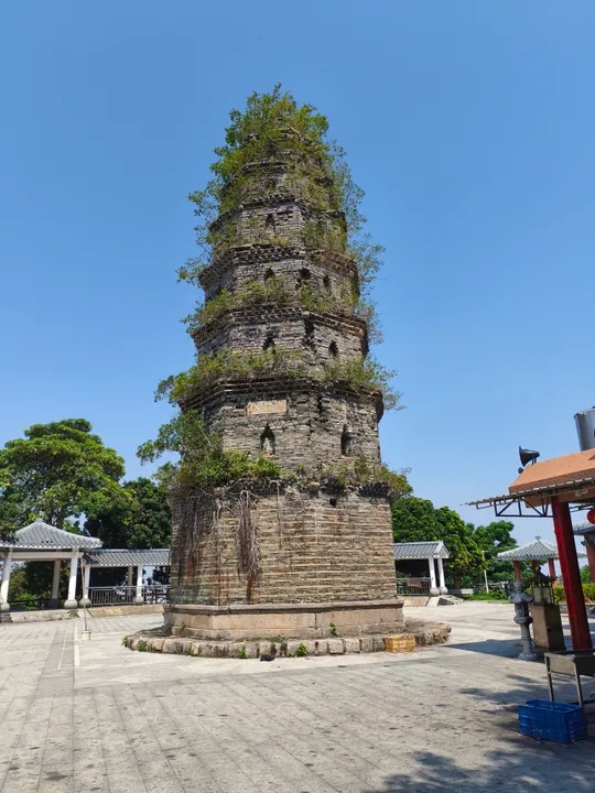
Photo adjustments
Full frame retained; proportionally resized and converted to WebP. No retouching or changes to the photographed subject. Card displays may crop the view.
- Administrative area
- District · 市辖区
- Part of
- Shantou
- Chinese name
- 潮南区
- Local areas
- District guide
Area & population
- Area in the source
- 596.42 km²
- Population · 2020
- 1,231,638
Source: cited geographic source, as of the dates shown.
Setting and landscape
The district government sums up the terrain as 'one mountain, one river, one plain'. In the southwest rises Dananshan (大南山), a branch of the Lianhua Mountains (莲花山脉), mostly 300 to 400 metres high and topped by Leiling Dashan (雷岭大山) at 521.2 metres. Along the northern edge the Lian River has built a flat delta plain around Chendian (陈店), Simapu (司马浦) and Xiashan (峡山); its largest tributary, the Liangying River (两英河), rises in Dananshan. The 14.7-kilometre coast is a sand bar from Longtian (陇田) to Jingdu (井都), fixed by casuarina windbreaks planted from the 1950s. The hills are the district's main rainstorm centre, and Hongchang (红场) and Leiling (雷岭) see five to ten days of frost a year while the coast has almost none.
History
Until 2003 Chaonan was part of Chaoyang, which became a county-level city in 1993. In January 2003 Chaoyang city was abolished and twelve of its towns became Chaonan District of Shantou, with the government at Xiashan.
At Jingdu, Xilin Nunnery (西林庵) was expanded in 1389 as the Jinshi Lan Temple by Zheng Youwu (郑有武), destroyed by Japanese pirates, rebuilt in 1692 by the military graduate Zheng Xuan (郑宣) and renamed. It later housed the Jingdu Peasant Association and is a district-level protected site. In early 1931 Red Army units set up a field hospital in a natural cave under granite boulders near Daxiba village (大溪坝村) in Hongchang, locally called Tiger Cave, where surgeons could perform amputations; the site was added to the tenth provincial list of protected sites in 2022.
What to see
The district government promotes Chaonan Yingge (潮南英歌), Huayao Chaozhou music (华瑶潮州音乐), Daliao inlaid porcelain (大寮嵌瓷) and Luxi murals (胪溪壁画) as intangible heritage, and names the Ke family temple at Xiashan (峡山柯氏家庙) and the Dongli old fort (东里古寨) among protected monuments. Chengtian ruled-line painting (成田界画) goes back to the late-Qing artist Ma Zhou (马骤) and has passed down his family for over a century. Painters draw ink lines over lacquer on halls, temples and houses, then colour and varnish them, using a flat, multi-point perspective. Hongchang is the main tea area, growing 16 varieties including Baiye Dancong (白叶单丛).
Getting oriented
Xiashan, the urban centre, is 33 kilometres from urban Shantou. The Shenzhen–Shantou Expressway crosses the coastal towns of Jingdu, Longtian and Leiling, and National Highway 324 runs through Xiashan, Simapu and Chendian towards Puning (普宁). Most people speak the Chaoyang variety of Teochew, while Leiling is Hakka-speaking.
Highlights
- Red Army Hospital site 红场镇红军医院遗址: 1931 cave hospital in Hongchang, a provincial protected site since 2022.
- Xilin Nunnery 西林庵: Jingdu temple expanded in 1389 and rebuilt in 1692; later home of the Jingdu Peasant Association.
- Chengtian ruled-line painting 成田界画: Family tradition of architectural painting dating from the late Qing.
- Dananshan 大南山: Hill range in the southwest topped by Leiling Dashan, 521.2 m.
Sources for this guide
自然地理_自然位置_潮南区人民政府门户网站 · Chaonan District People's Government, Shantou
潮南概况_潮南概况_潮南区人民政府门户网站 · Chaonan District People's Government, Shantou
汕头市潮南区历史沿革_历史沿革_潮南区人民政府门户网站 · Chaonan District People's Government, Shantou
潮南区 - 维基百科,自由的百科全书 · Wikipedia · CC BY-SA 4.0
井都镇西林庵_名胜旅游_潮南区人民政府门户网站 · Chaonan District People's Government, Shantou
潮南区红场镇红军医院遗址_名胜旅游_潮南区人民政府门户网站 · Chaonan District People's Government, Shantou
潮南区:打造文化旅游事业发展新高地_名胜旅游_潮南区人民政府门户网站 · Chaonan District People's Government, Shantou
成田界画:真实、细致的艺术之美_民俗风情_潮南区人民政府门户网站 · Chaonan District People's Government, Shantou
Original English written from the listed sources and checked sentence by sentence against quoted extracts by a separate reviewer. Updated 2026-09-23.
Explore Chaonan District
Core places to explore, with English and Chinese names.
Chaonan District 潮南区
Plan your visit
Getting there
Chaonan District is about 30 km in a straight line from central Shantou. Search for 潮南区 in a map app to find stations and your accommodation.
Where to stay →More in Shantou
Sources & geographic information
Administrative names and parent areas: Official geographic directory · Reference date 2026-09-06.
Some facts checked against 潮南区 — Wikipedia contributors, CC BY-SA 4.0.
Map data © OpenStreetMap contributors. Pins mark approximate centres, not entrances or boundaries.