

Photo adjustments
EXIF orientation normalized; resized without changing aspect ratio; converted to WebP. No subject edits.
Explore the region
About Ningming Huashan Rock Art
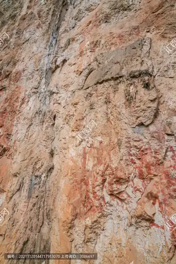
Human forms with bent knees and raised arms appear alongside animals, drums and objects, creating a pattern whose details become clearer once you understand the scale of the rock face. The boat approach along the Mingjiang adds the surrounding karst landscape to the visit. Start with the digital exhibition if possible, then compare its explanation with the paintings viewed from the managed cliff-side route.
What to look for
- Red human figures with bent knees and raised arms dominate the cliff panel.
- Animal, drum and tool images sit within the broader painted composition.
Location & getting there
Getting to Ningming Huashan Rock Art
Go to the Huashan Rock Art scenic visitor centre in Ningming, then use its transfer arrangements for Bahe boat wharf. The documented river approach leaves from Bahe; confirm the operating departure point rather than choosing an unrelated village wharf.
Combine your visit
Suggested order for the visit:
-
Visitor-centre digital exhibition
Get context for the figures and their conservation.
-
Bahe wharf river journey
Approach the cliff along the Mingjiang.
-
Rock-art viewing route
Compare the red figures with the size of the limestone wall.
This is an editorial sequence of named spaces or places. It does not imply a verified walking connection or promise opening, ticket availability or a journey time.
Find Ningming Huashan Rock Art
宁明花山岩画 · 崇左
The pin marks the area, not the entrance.
More places nearby
Approximate straight-line distances between map pins, not travel distances.
Friendship Pass 友谊关
45 km awayFriendship Pass is an architectural border landmark as well as a place associated with repeated military and diplomatic encounters. The rebuilt gate tower combines a heavy arched base with upper galleries, while walls extend…
View guide →Mingshi Countryside 明仕田园
51 km awayMingshi places a slow river between limestone peaks, rice fields and village buildings. A bamboo-raft excursion shows the landscape from water level, where the fields and the bases of the hills become part of the same view. The…
View guide →Detian Falls 德天瀑布
74 km awayDetian Falls spread across a broad limestone river edge on the China–Vietnam border. Rocks and trees divide the water into separate drops, with the curtains joining more strongly when the river carries more water. The…
View guide →Sources & visit information
The sources below support the place-specific description and arrival information. Suggested combinations are editorial planning ideas; confirm current opening, entry arrangements and transport services for your date.