


Get to know Guiping

Photo adjustments
Full frame retained; resized proportionally to a maximum dimension of 960 pixels and converted to WebP quality 88. No crop, retouch, generated elements, or subject alteration. Final website rendition: full frame retained, proportionally resized to at most 720 pixels and converted to WebP. No additional retouching or subject alteration. Card displays may crop the view.
- Administrative area
- County-level city · 县级市
- Part of
- Guigang
- Chinese name
- 桂平市
- Local areas
- County-level city guide
Area & population
- Area in the source
- 4,074.00 km²
- Population · 2005
- 1,700,000
- Administrative seat
- Xishan (西山镇)
Source: cited geographic source, as of the dates shown.
Setting and landscape
The city covers 4,074 square kilometres. The Xi River (西江) runs through it for 168 kilometres, and the city government describes the Xunyu Plain as the largest alluvial plain in Guangxi. Datengxia (大藤峡), which the government calls the largest gorge in the Pearl River basin, also lies within the city.
History
Guiping, also called Xunzhou (浔州), has been a seat of commanderies, prefectures and circuits for more than 2,200 years. The Qin founded Guilin Commandery (桂林郡) in 214 BC with its seat at Bushan (布山), in today's Mengxu town (蒙圩镇); the names Guiping Commandery and Guiping County date from AD 502. Xunzhou was set up under the Tang, and under the Yuan, Ming and Qing the city was the seat of Xunzhou circuit and prefecture.
The Yao rising at Datengxia in the Ming and the Taiping Heavenly Kingdom's Jintian Uprising (金田起义) both began here, and rebels of the Heaven and Earth Society (天地会) made Guiping the capital of their Dacheng (大成国) state, renaming it Xiujing (秀京). Guiping County became a county-level city on 18 May 1994.
What to see
Xishan (西山), a national key scenic area, AAAA scenic area and national geopark, is known for its forest, rocks, springs, tea and Buddhism. Longtan National Forest Park (龙潭国家森林公园), also AAAA, is promoted as the "green emerald on the Tropic of Cancer". The Taiping Jintian Uprising Site (太平天国金田起义地址) was in the first national list of key cultural relics in 1961. Other sights are the Baishi Cave Heaven (白石洞天), counted as the 21st of the 36 Daoist cave heavens, the East Pagoda (东塔), listed by the city as the tallest surviving old pagoda in Guangxi, and the Tropic of Cancer marker park (北回归线标志公园).
Food and local products
Xishan tea (西山茶), nicknamed the "Longjing of Guangxi", was among the first 35 geographical-indication products mutually recognised by China and the EU. Luoxiu rice noodles (罗秀米粉), Madong lychees (麻垌荔枝), Jintian yam (金田淮山) and Shepo dried tofu skin (社坡腐竹) are the other products the city names, and it farms a soft-shelled turtle called huangshabie (黄沙鳖).
Getting oriented
The Nanning–Guangzhou high-speed railway has a station at Guiping, and a Guiping North (Jintian) station is being built on the Liuzhou–Wuzhou line. Ships of 2,000 tonnes can sail up the Qian and Yu rivers to Nanning and Liuzhou.
Highlights
- Xishan 西山: National key scenic area, AAAA scenic area and national geopark known for forest, rocks, springs, tea and Buddhism.
- Taiping Jintian Uprising Site 太平天国金田起义地址: In the first national list of key cultural relics, 1961.
- Longtan National Forest Park 龙潭国家森林公园: AAAA forest park promoted as the green emerald on the Tropic of Cancer.
- Datengxia 大藤峡: Described by the city as the largest gorge in the Pearl River basin; base of the Ming-dynasty Yao rising.
- East Pagoda 东塔: Listed by the city as the tallest surviving old pagoda in Guangxi.
- Xishan tea 西山茶: Among the first 35 China–EU mutually recognised geographical indications.
Explore Guiping
Core places to explore, with English and Chinese names.
Places to explore around Guiping
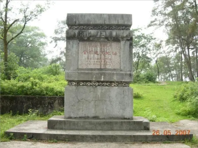 Jintian Uprising Site of the Taiping Heavenly Kingdom · 太平天国金田起义旧址
Jintian Uprising Site of the Taiping Heavenly Kingdom太平天国金田起义旧址
The Jintian uprising site marks the place on Xiniuling, a hill ridge beside Jintian village in Jintian town, Guiping, where the Taiping rising began on 11 January 1851. Its principal relics include an earth-walled camp, and the State Council placed the site in the first national batch of protected monuments in 1961.
Read the place guide → AI illustration · AI 示意图(仅供参考,非该地点实拍)
Guiping Xishan Scenic Area西山
Xishan is the scenic mountain at Xishan town in Guiping, Guigang, eastern Guangxi. Guiping city describes it as a national scenic area, and the buildings standing on it include the Xishi'an nunnery and the Ruquan pavilion.
Read the place guide → Longtan National Forest Park · 龙潭国家森林公园
Longtan National Forest Park龙潭国家森林公园
Longtan National Forest Park occupies hill country in the north-west of Guiping, Guigang, in eastern Guangxi, about 18 kilometres from the city centre. The former Ministry of Forestry approved it as a national forest park in 1993, and the Tropic of Cancer runs across its southern part.
Read the place guide →Plan your visit
Getting there
Guiping is about 60 km in a straight line from central Guigang. Search for 桂平市 in a map app to find stations and your accommodation.
Where to stay →Build your route
Jintian Uprising Site of the Taiping Heavenly Kingdom and Guiping Xishan Scenic Area are both listed here. The linked place guides have entrance and visit details.
Continue with Guigang →More in Guigang
Sources & geographic information
Administrative names and parent areas: Official geographic directory · Reference date 2026-09-06.
Photo: Jintian Uprising Site of the Taiping Heavenly Kingdom · Source photographer · License not provided. EXIF orientation normalized; resized without changing aspect ratio; converted to WebP. No subject edits.
Photo: Longtan National Forest Park · Source photographer · License not provided. EXIF orientation normalized; resized without changing aspect ratio; converted to WebP. No subject edits.
Map data © OpenStreetMap contributors. Pins mark approximate centres, not entrances or boundaries.