

Photo adjustments
Wikimedia thumbnail; fitted to the ranking-card frame.
Explore the region
About Moon Hill
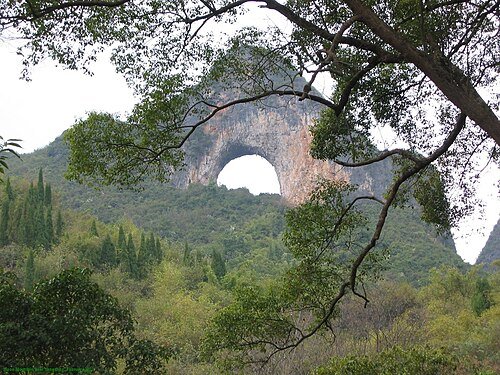
From the Fenglou area the semicircular opening stands clearly against the sky, with other karst hills rising around it. Current visitor listings still report the scenic area as temporarily closed, so plan this as an exterior landscape stop unless the operator confirms reopening. Older accounts of the stair climb should not be treated as permission to enter a closed trail.
Moon Hill is part of the Guilin Mountains chain. Its arch is what remains of a limestone cave that formed in the phreatic zone; like most formations in the region it is karst. The hill lies south of Yangshuo across the Jingbao River, along China National Highway 321, and has an elevation of 380 meters, a relative height of 230 meters and a length of 410 meters; the arch itself is about 50 meters high. From the hill, views extend across the surrounding countryside, characterized by the karst hills found throughout the region.
What to look for
- The large limestone arch gives the hill its unmistakable moon-shaped profile.
- The surrounding Fenglou karst landscape can be appreciated from permitted public approaches.
Location & getting there
Getting to Moon Hill
Approach the Fenglou Village area beside the Guili highway in Gaotian, south of Yangshuo. The hill is on the highway’s western side. Check the entrance status before making a dedicated trip; do not enter a closed or fenced trail.
- Closure evidence is a current visitor-platform listing, supported by the dated Wikivoyage notice; no official reopening announcement was established.
Combine your visit
Suggested order for the visit:
-
Fenglou public approach
Look for a permitted exterior view of the arch.
-
Big Banyan scenic area
Consider this separately operated nearby stop after checking its own access.
This is an editorial sequence of named spaces or places. It does not imply a verified walking connection or promise opening, ticket availability or a journey time.
Find Moon Hill
月亮山 · 阳朔县
The pin marks the area, not the entrance.
More places nearby
Approximate straight-line distances between map pins, not travel distances.
Yangshuo Big Banyan Tree 阳朔大榕树
2 km awayYangshuo’s Big Banyan spreads a broad canopy beside the Jinbao River. Its hanging aerial roots and branches growing close to the ground make one tree resemble a small grove. The setting also carries a cinematic association: the…
View guide →Yangshuo Butterfly Spring Cave 阳朔蝴蝶泉岩洞
3 km awayTianlai Butterfly Spring combines a small cave and hill viewpoint with staged Miao and Dong cultural performances. A large butterfly sculpture on the rock face marks the entrance, while a butterfly-like cave formation explains…
View guide →Ruyi Peak Scenic Area 阳朔如意峰
5 km awayRuyi Peak is a developed hilltop attraction that uses a cableway and elevated paths to reveal Yangshuo’s limestone landscape. Yuanbao, Ruyi and Xianglian peaks frame the visit, with a viewing platform, suspension bridge and…
View guide →Sources & visit information
The sources below support the place-specific description and arrival information. Suggested combinations are editorial planning ideas; confirm current opening, entry arrangements and transport services for your date.
- Moon Hill ↗
- Wikivoyage: Yangshuo ↗
- Trip.com: Moon Hill current visitor listing ↗
- Chinese Wikipedia: 月亮山 (revision 89359351, 2025-10-01) ↗
- English Wikipedia: Moon Hill (revision 1304515612, 2025-08-06) ↗
Visitor information adapted and edited from Wikipedia contributors, “Moon Hill” · CC BY-SA 4.0. Source revision 1304515612.
Visitor information adapted and edited from Wikivoyage contributors, Yangshuo · CC BY-SA 4.0. Source revision 5339960.
Background paragraphs translated and condensed from Wikipedia contributors, "月亮山", Chinese Wikipedia · CC BY-SA 4.0. Source revision 89359351.
Background paragraphs condensed from Wikipedia contributors, "Moon Hill", English Wikipedia · CC BY-SA 4.0. Source revision 1304515612.