


Get to know Babu District
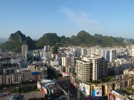
Photo adjustments
Resized and WebP compressed; subject not altered.
- Administrative area
- District · 市辖区
- Part of
- Hezhou
- Chinese name
- 八步区
- Local areas
- District guide
Area & population
- Area in the source
- 5,334.00 km²
- Population · 2020 census
- 655,994
- Administrative seat
- Chengdong Subdistrict
Source: cited geographic source, as of the dates shown.
Setting and landscape
Babu lies in the southern part of the central Nanling range (南岭). Gupo Mountain (姑婆山), the tail of the Mengzhu Range (萌渚岭), enters from Jianghua (江华) in Hunan and gives the north and east their high ridges; the highest summit is Ma'an Mountain (马鞍山, 1,846 m) in Lisong town (里松镇). Dagui Mountain (大桂山) runs across the middle and splits the district in two. The He River, a tributary of the Xi River, flows 120.2 km north to south through the district before crossing into Fengkai (封开) in Guangdong.
History
In 111 BC the Western Han created Linhe (临贺) county, with its seat at today's Hejie town (贺街镇), and Fengyang (封阳) county, seated at today's Pumen town (铺门镇). Linhe later became the seat of a commandery and, from 589, of Hezhou prefecture. In 1377 the prefecture was downgraded to He County, named after the He River; the county seat moved to Babu town in 1952. He County became the county-level city of Hezhou in 1997, and Babu District was created when Hezhou became a prefecture-level city in 2002.
What to see
The Linhe ancient city (临贺故城) at Hejie was founded in 111 BC and uses the He River as a natural barrier; its core sights are the Hezhou Confucian Temple (贺州文庙) and old city walls. The district calls it one of China's longest-used county seats and the only well-preserved Western Han city in Guangxi. It is a national key cultural relics site, as is the Jiang family Hakka enclosed house (江氏客家围屋).
Dagui Mountain National Forest Park (大桂山国家森林公园), one of China's first national forest parks, rises to Liuyangding (留羊顶, 1,208 m), which looks over the winding He River. Its Wuma Guicao waterfall (五马归槽瀑布), about 30 m high, is fed by five gorge streams.
Fengyang Stone City (封阳石城) in Pumen was built in 1571 in a hollow enclosed by sheer rock hills to the east and west, with stone walls and gates closing the gaps to the north and south. Xindu (信都) subprefecture, created in 1906, later moved its offices to just outside the north gate, and the Xindu county government that replaced it in 1912 stayed there until 1919.
Food and local products
The district government calls Babu "China's home of plums". Its registered geographical-indication products are Xindu red melon seeds (信都红瓜子), Xindu three-yellow chicken (信都三黄鸡), Hejie Chinese yam (贺街淮山), Kaishan white-hair tea (开山白毛茶), Babu Sanhua plums (八步三华李) and Babu Nanxiang duck (八步南乡鸭).
Highlights
- Linhe ancient city 临贺故城: Western Han county seat founded in 111 BC at Hejie; national key site and AAAA scenic area since 2022.
- Dagui Mountain National Forest Park 大桂山国家森林公园: One of China's first national forest parks; Liuyangding summit at 1,208 m.
- Fengyang Stone City 封阳石城: Walled hollow among sheer rock hills in Pumen, built in 1571.
- Babu Sanhua plum 八步三华李: One of six registered geographical-indication products of the district.
Sources for this guide
八步区区情概貌 - 区域概况 - 广西贺州市八步区人民政府门户网站 · Babu District People's Government, Hezhou
贺州市临贺故城景区 - 旅游指南 - 广西贺州市八步区人民政府门户网站 · Babu District Bureau of Culture, Radio, Television and Tourism
大桂山国家森林公园 - 旅游指南 - 广西贺州市八步区人民政府门户网站 · Babu District Bureau of Culture, Radio, Television and Tourism
封阳石城 - 旅游指南 - 广西贺州市八步区人民政府门户网站 · Babu District Bureau of Culture, Radio, Television and Tourism
Original English written from the listed sources and checked sentence by sentence against quoted extracts by a separate reviewer. Updated 2026-09-24.
Explore Babu District
Core places to explore, with English and Chinese names.
Babu District 八步区
Plan your visit
Getting there
Babu District covers the centre of Hezhou. Search for 八步区 in a map app to find stations and your accommodation.
Where to stay →More in Hezhou
Sources & geographic information
Administrative names and parent areas: Official geographic directory · Reference date 2026-09-06.
Map data © OpenStreetMap contributors. Pins mark approximate centres, not entrances or boundaries.