


Get to know Pinggui District
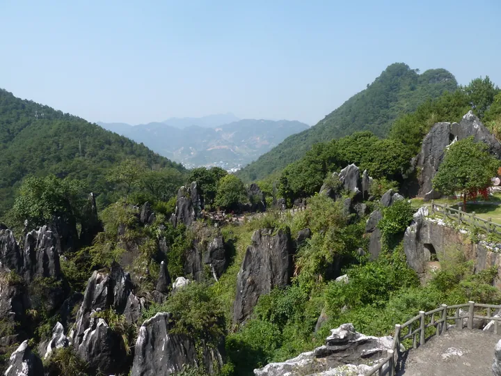
Photo adjustments
Full frame retained; proportionally resized and converted to WebP. No retouching or changes to the photographed subject. Card displays may crop the view.
- Administrative area
- District · 市辖区
- Part of
- Hezhou
- Chinese name
- 平桂区
- Local areas
- District guide
Area & population
- Area in the source
- 2,022.00 km²
- Population · 2016
- 415,000
- Administrative seat
- Xiwan Subdistrict
Source: cited geographic source, as of the dates shown.
Setting and landscape
The land is high in the northeast, low and level in the middle and steep in the south. Gupo Mountain, at 1,730 m, is the district's highest peak, and Litouding (犁头顶), the main summit of Dagui Mountain, reaches 1,253 m. Around Huangtian (黄田), Xincun (新村), Wanggao (望高) and Baisha (白沙), eroded and dissolved limestone stands in pillars, peaks and cliffs that often form stone forests, and more than a hundred karst caves have been found.
The main river is the Fu River (富江), which rises in Hunan and flows through Fuchuan and Zhongshan before entering Pinggui at Yangtou (羊头) and Xiwan (西湾). The Lisong River (里松河), also called the Mawei River, rises on Ma'an Mountain (马鞍山) and runs south past the Lisong and Xinlu mining areas to join the He River (贺江).
History
The district's forerunner was the Pinggui Mining Bureau (平桂矿务局), founded in 1938 and run under the national metallurgy ministry after 1949. It produced mainly tin and tungsten and was one of China's three main sources of refined tin. As its ore ran out it declined, and it was closed through bankruptcy in 2002. Guangxi set up the Pinggui Management Zone in 2007, and the State Council approved Pinggui District on 8 June 2016.
What to see
Hezhou Jade Stone Forest (贺州玉石林) in Huangtian town was first opened as the Jinqi Stone Forest. It took its present name after geologists attending a 2003 national geology meeting in Hezhou visited and noticed the mountain's white stone. Moss that has dried on the rock stains many pillars black, so the forest is patterned black and white, and tin has been mined from its ore veins since the Song dynasty.
The stone forest shares a tourist route with Gupo Mountain National Forest Park (姑婆山国家森林公园), Hezhou Hot Springs (贺州温泉) and Shibashui (十八水, "Eighteen Waters"). The Gupo Mountain nature reserve, the Shibashui scenic area and the hot springs are all in Huangtian.
Food and local products
Fanglin water chestnuts (芳林马蹄) are a geographical-indication regional brand. Pinggui lotus root, oil-sticky rice (油粘米), black tea, tomatoes and fragrant pigs (香猪) joined the national list of distinctive new farm products in 2023.
Getting oriented
Pinggui lies 6 km from Hezhou's urban area. It borders Babu (八步区) to the east, Zhongshan (钟山) and Zhaoping (昭平) to the west, Cangwu (苍梧) to the south, and Fuchuan (富川) and Jianghua (江华) in Hunan to the north. Hezhou Station on the Guiyang-Guangzhou high-speed railway (贵广客运专线) serves the district.
Highlights
- Hezhou Jade Stone Forest 贺州玉石林: Black-and-white stone forest in Huangtian with tin veins mined since the Song dynasty.
- Gupo Mountain 姑婆山: Highest peak of the district at 1,730 m; national forest park and nature reserve in Huangtian.
- Shibashui 十八水: Scenic area at Luhua village, on the same route as the stone forest and hot springs.
- Fanglin water chestnut 芳林马蹄: Geographical-indication regional brand of the district.
Sources for this guide
2025年平桂区自然地理概况 - 自然地理 - 广西贺州市平桂区人民政府门户网站 · Pinggui District Office of Party History and Local Chronicles
2024年平桂区概况 - 基本情况 - 广西贺州市平桂区人民政府门户网站 · Pinggui District Office of Party History and Local Chronicles
玉石林景区 - 旅游景点 - 广西贺州市平桂区人民政府门户网站 · Pinggui District Bureau of Culture, Radio, Television and Tourism
平桂区旅游景点 - 旅游景点 - 广西贺州市平桂区人民政府门户网站 · Pinggui District Bureau of Culture, Radio, Television and Tourism
平桂名特优农产品 - 名优特产 - 广西贺州市平桂区人民政府门户网站 · Pinggui District People's Government
平桂区 - 维基百科,自由的百科全书 · Wikipedia (Chinese) · CC BY-SA 4.0
Original English written from the listed sources and checked sentence by sentence against quoted extracts by a separate reviewer. Updated 2026-09-24.
Explore Pinggui District
Core places to explore, with English and Chinese names.
Places to explore around Pinggui District
 Hezhou Jade Stone Forest ·
 Plan your visit
Getting there
Pinggui District is about 10 km in a straight line from central Hezhou. Search for 平桂区 in a map app to find stations and your accommodation.
Where to stay →Build your route
Start with Hezhou Jade Stone Forest. The linked place guides have entrance and visit details.
Continue with Hezhou →More in Hezhou
Sources & geographic information
Administrative names and parent areas: Official geographic directory · Reference date 2026-09-06.
Some facts checked against 平桂区 — Wikipedia contributors, CC BY-SA 4.0.
Photo: Hezhou Jade Stone Forest · Source photographer · License not provided. EXIF orientation normalized; resized without changing aspect ratio; converted to WebP. No subject edits.
Map data © OpenStreetMap contributors. Pins mark approximate centres, not entrances or boundaries.