


Get to know Beiliu

- Administrative area
- County-level city · 县级市
- Part of
- Yulin
- Chinese name
- 北流市
- Local areas
- County-level city guide
Area & population
- Area in the source
- 2,457.00 km²
- Population · 2020
- 1,211,637
- Administrative seat
- Lingcheng
Source: cited geographic source, as of the dates shown.
Setting and landscape
The city is named after the Beiliu River (北流江), which flows from south to north; Su Dongpo (苏东坡), passing in the Northern Song, called it the Gui River (圭江) after a rock in the stream shaped like a gui tablet. Townships are grouped by the Beiliu River basin into Shangli (上里) in the south and Xiali (下里) in the north, which differ in speech and customs. Beiliu lies south of the Tropic of Cancer and has a subtropical monsoon climate.
Darong Mountain, about 20 kilometres from the urban area, runs east to west for more than 40 kilometres. Its main summit, Lianhua Peak (莲花顶), reaches 1,275.6 metres, and the Beiliu government calls it the highest peak in southeast Guangxi. Forest covers 82.7% of the mountain, where tree ferns (桫椤) grow.
History
The Southern Qi set up Beiliu Commandery in 488. Under the Tang, Beiliu served for more than a century as the seat of Rongzhou (容州). West of the city, between Beiliu and Yulin, is the Ghost Gate Pass (鬼门关), once a key point on the route to Qinzhou, Lianzhou, Leizhou, Hainan and Jiaozhi (交趾); disease was so rife that few who went there returned, hence the name. Exiled officials passing through included Shen Quanqi (沈佺期), Li Deyu (李德裕) and Su Shi (苏轼). In 1905 magistrate Gao Tingmei (高廷梅) built the Jingsu Tower (景苏楼) at Su's old landing to mark his two visits.
What to see
Goulou Cave, 3 kilometres east of the city, links four caves, Baogui, Yuque, Baisha and Taoyuan, over about one kilometre. Legend says the Eastern Jin Daoist Ge Hong (葛洪) became an immortal here, and it is counted as the 22nd of Daoism's 36 grotto-heavens. Tongshiling (铜石岭), in Min'an town (民安镇), keeps Han-dynasty copper-smelting and bronze-drum casting sites among Danxia and karst landforms. Simadi (司马第) in Xinxu town (新圩镇) is a Qing house compound begun in 1815, nicknamed the "wok-ear building" (镬耳楼) for its gables.
Food and local products
Beiliu's pottery flourished in the Song, when it was compared with Jingdezhen; a ceramics museum beside the city's ceramics trade centre shows nearly 1,000 objects. Fish from the Yatang Baiquan Lake (鸭塘百泉湖) were once sent as tribute. Luozheng rice noodles (罗政米粉) come from Luozheng village at the foot of Darong Mountain, made with the mountain's spring water, local rice and water-milling. Liangting chicken (凉亭鸡) is a national geographical-indication product, and Beiliu is one of the main lychee-growing areas of Lingnan.
Highlights
- Goulou Cave 勾漏洞: Four connected karst caves 3 km east of the city, linked in legend with Ge Hong; a 4A scenic area since 2022.
- Darong Mountain 大容山: National forest park whose 1,275.6 m Lianhua Peak is called the highest in southeast Guangxi.
- Tongshiling 铜石岭: Han-dynasty copper-smelting and bronze-drum casting site among Danxia and karst landforms.
- Jingsu Tower 景苏楼: Built in 1905 to commemorate Su Dongpo's two passages through Beiliu.
- Luozheng rice noodles 罗政米粉: Water-milled rice noodles from Luozheng village in Minle town, made with Darong Mountain spring water.
Sources for this guide
旅游资源 - 广西玉林北流市人民政府门户网站 · Beiliu Municipal People's Government (from the Beiliu Yearbook)
北流市 - 维基百科,自由的百科全书 · Wikipedia (Chinese) · CC BY-SA 4.0
罗政米粉香飘四方 - 地方美食 - 广西玉林北流市人民政府门户网站 · Beiliu Municipal People's Government (Beiliu Media Centre report)
Original English written from the listed sources and checked sentence by sentence against quoted extracts by a separate reviewer. Updated 2026-09-24.
Explore Beiliu
Core places to explore, with English and Chinese names.
Places to explore around Beiliu
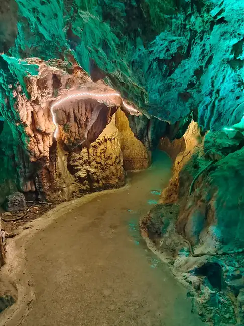 Goulou Cave ·
 Plan your visit
Getting there
Beiliu is about 20 km in a straight line from central Yulin. Search for 北流市 in a map app to find stations and your accommodation.
Where to stay →Build your route
Start with Goulou Cave. The linked place guides have entrance and visit details.
Continue with Yulin →More in Yulin
Sources & geographic information
Administrative names and parent areas: Official geographic directory · Reference date 2026-09-06.
Some facts checked against 北流市 — Wikipedia contributors, CC BY-SA 4.0.
Photo: Goulou Cave · Source photographer · License not provided. EXIF orientation normalized; resized without changing aspect ratio; converted to WebP. No subject edits.
Map data © OpenStreetMap contributors. Pins mark approximate centres, not entrances or boundaries.