


Get to know Libo County
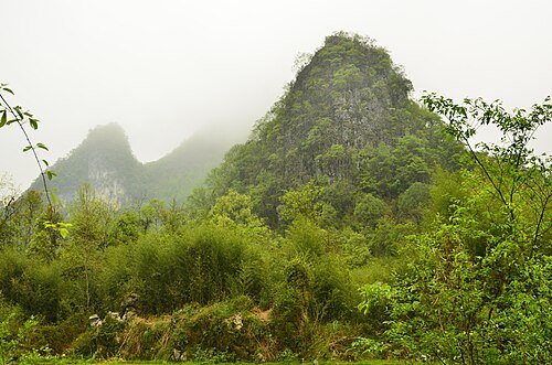
Photo adjustments
Wikimedia thumbnail; fitted to the ranking-card frame.
- Administrative area
- County · 县
- Part of
- Qiannan Buyei and Miao Autonomous Prefecture
- Chinese name
- 荔波县
- Local areas
- County guide
Area & population
- Area in the source
- 2,432.00 km²
- Population · 2010
- 144,849
- Administrative seat
- Yuping
Source: cited geographic source, as of the dates shown.
Setting and landscape
The land is high in the north and low in the south, from 1,468 metres on a secondary peak of Yueliang Mountain (月亮山) in the northeast to 300 metres where the Dagou River (打狗河) leaves the county. Mountains make up about 72 percent of the area. All rivers drain to the Pearl River (珠江); the largest system is the Dagou, which includes the main stream of the Zhang River (樟江).
The climate is warm and wet, with a mean of 18.5°C and most of the 1,212 mm of annual rain falling from April to September.
What to see
The Zhangjiang scenic area is rated 5A. One of its four sectors is Xiaoqikong (小七孔), 46.4 square kilometres of forest, caves, lakes and water, known as a "super bonsai". Its 21 sights include the old Xiaoqikong bridge, the Laya Waterfall (拉雅瀑布), a 68-step cascade, a forest standing in water and Yuanyang Lake (鸳鸯湖).
Daqikong (大七孔), 25 km south of the county town, takes its name from a seven-arched bridge over the Dagou River near Mengtang village (孟塘村). It is a landscape of primeval forest, gorges, underground streams and an underground lake, and at sights such as Fengshen Cave (风神洞) waterfalls drop into lakes inside the caves, with openings in the rock above.
The Maolan National Nature Reserve (茂兰国家级自然保护区) is a World Heritage area and a member of the world biosphere reserve network, with karst forest growing in closed sinkholes. Its Latan Waterfall (拉滩瀑布), about 70 metres high, is the largest in the reserve.
Yaoshan Old Village (瑶山古寨), a 4A scenic area, is presented as the only village in Guizhou where the Baiku Yao (白裤瑶) live together. It has earth-walled, thatched houses, a large bronze drum on its central square and clusters of old granaries.
History
In 970 the Song set up a loose-rein Libo Department here. Under the Ming it was merged into Guangxi and restored as a county in 1506, and it moved between Guangxi and Guizhou until 1732, when it was placed under Duyun Prefecture (都匀府). The county seat moved to today's town in 1737. Libo was merged into Dushan County in 1959 and restored in 1961. It is the home town of Deng Enming (邓恩铭), a delegate to the first congress of the Communist Party of China.
Buyei (布依族), Sui (水族), Miao (苗族) and Yao (瑶族) people live in the county. The Yao monkey-drum dance and the Buyei nuo opera are on the national intangible heritage list.
Highlights
- Xiaoqikong 小七孔: Sector of the 5A Zhangjiang scenic area with 21 sights, including the old Xiaoqikong bridge, Laya Waterfall and a 68-step cascade.
- Daqikong 大七孔: Forest, gorges and underground streams, named after a seven-arched bridge over the Dagou River.
- Maolan National Nature Reserve 茂兰国家级自然保护区: Karst forest in a World Heritage area; the Latan Waterfall falls about 70 metres.
- Yaoshan Old Village 瑶山古寨: 4A scenic area; described as Guizhou's only Baiku Yao village, with earth-walled houses and old granaries.
Sources for this guide
荔波概况 · Libo County People's Government
历史沿革 · Libo County People's Government
小七孔景区 · Libo County People's Government
大七孔景区 · Libo County People's Government
瑶山古寨:自然与人文的交响 · Libo County People's Government
自然地理 · Libo County People's Government
贵州茂兰国家级自然保护区 · Libo County People's Government
Original English written from the listed sources and checked sentence by sentence against quoted extracts by a separate reviewer. Updated 2026-09-25.
Explore Libo County
Core places to explore, with English and Chinese names.
Places to explore around Libo County
 A suspension footbridge over a turquoise pool at the Daqikong Scenic Area scenic area, Libo County · 荔波大七孔景区,吊桥与碧潭 Source-recorded photograph date: 26 March 2024 (according to Exif data).
Daqikong Scenic Area大七孔
Daqikong (大七孔) is a gorge district of the Zhangjiang scenic area in Libo County, in the Qiannan prefecture of southern Guizhou, three kilometres from the neighbouring Xiaoqikong district and different in character. Its landmarks are a natural bridge left by a collapsed cave roof and the Qing bridge the district is named after.
Read the place guide →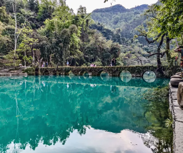 The seven-arch stone bridge and green river in Xiaoqikong Scenic Area, Libo · 荔波小七孔古桥与河水
Xiaoqikong Scenic Area小七孔
Xiaoqikong (小七孔) is a karst river district in the south-west of Libo County, in the Qiannan prefecture of southern Guizhou, about 28 kilometres from the county town. It covers roughly 46.4 square kilometres and is one of the four districts of the Zhangjiang scenic area.
Read the place guide →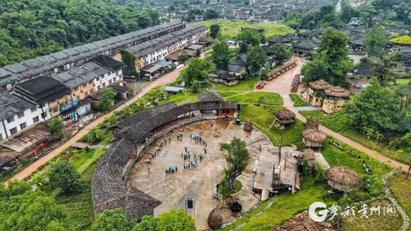 Yaoshan Ancient Yao Village · 瑶山古寨
Yaoshan Ancient Yao Village瑶山古寨
Yaoshan (瑶山古寨) is a Baiku Yao settlement taking in Lapian and Gulei villages in Yaoshan Yao township, Libo County, in the Qiannan prefecture of southern Guizhou, about 35 kilometres from the county town and some 3 kilometres from the Xiaoqikong scenic area. It covers 3.6 square kilometres and has become a 4A-grade scenic area.
Read the place guide →Plan your visit
Getting there
Libo County is about 100 km in a straight line from central Qiannan Buyei and Miao Autonomous Prefecture. Search for 荔波县 in a map app to find stations and your accommodation.
Where to stay →Build your route
Daqikong Scenic Area and Xiaoqikong Scenic Area are both listed here. The linked place guides have entrance and visit details.
Continue with Qiannan Buyei and Miao Autonomous Prefecture →More in Qiannan Buyei and Miao Autonomous Prefecture
Sources & geographic information
Administrative names and parent areas: Official geographic directory · Reference date 2026-09-06.
Photo: Daqikong Scenic Area · FN-082 · CC BY-SA 4.0. Full frame retained; proportionally resized and converted to WebP. No retouching or changes to the photographed subject. Card displays may crop the view.

Photo: Xiaoqikong Scenic Area · FN-082 · CC BY-SA 4.0. Full source framing retained; proportionally resized and converted to WebP. No retouching or subject alteration. Card displays may crop the view.

Photo: Yaoshan Ancient Yao Village · Source photographer · License not provided. EXIF orientation normalized; resized without changing aspect ratio; converted to WebP. No subject edits.
Map data © OpenStreetMap contributors. Pins mark approximate centres, not entrances or boundaries.